 view gallery view gallery W16.3 km W16.3 km
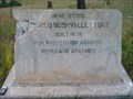
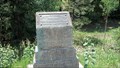
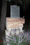
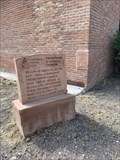
|   The Old Bushvalley Fort The Old Bushvalley Fort
in Arizona Historical Markers A marker just outside the town of Alpine along US-180. posted by:  leadhiker leadhiker location: Arizona date approved: 06/07/2011 last visited: never |
 view gallery view gallery SE16.6 km SE16.6 km
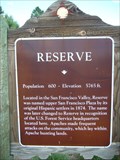
|  Reserve Reserve
in New Mexico Historical Markers There are two OSHM's for Reserve. The other one is about 6 miles east. posted by: leadhiker location: New Mexico date approved: 06/07/2011 last visited: 07/02/2012 |
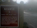 view gallery view gallerySE21.6 km | Reserve OSHM in New Mexico Historical Markers OSHM sign for Reserve,NM posted by:  kingbee kingbee location: New Mexico date approved: 08/19/2010 last visited: 07/02/2012 |
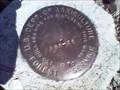
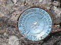
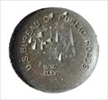 view gallery view gallerySE21.7 km |  US BUREAU OF PUBLIC ROADS 5764.34 9 US BUREAU OF PUBLIC ROADS 5764.34 9
in U.S. Benchmarks US BUREAU OF PUBLIC ROADS BM 5764.34 9 posted by: GEO*Trailblazer 1 location: New Mexico date approved: 01/01/2007 last visited: 01/01/2007 |
 view gallery view gallery NE36.9 km NE36.9 km
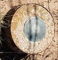
| ABR-28 U. S. Dept. of Agriculture Forest Service - Fox Mt. in U.S. Benchmarks Forest Service Marker ABR-28 is located approximately 26 miles south of Quemado, NM, on Fox Mountain. posted by: Hawikuh location: New Mexico date approved: 08/23/2009 last visited: never |
 view gallery view gallery N39.6 km N39.6 km
| Arizona Highway Dept. 1960 - Springerville, AZ in U.S. Benchmarks This marker sits just inside Arizona's border with New Mexico. posted by: rjmcdonough1 location: Arizona date approved: 08/26/2020 last visited: never |
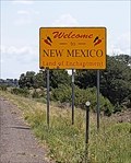 view gallery view galleryN39.6 km |  Welcome to New Mexico - New Mexico Arizona Border Welcome to New Mexico - New Mexico Arizona Border
in Welcome Signs This sign, on the south side of U.S. 60, welcomes travelers to the Land of Enchantment. posted by: rjmcdonough1 location: New Mexico date approved: 08/26/2020 last visited: never |
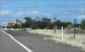 view gallery view galleryN39.6 km |  AZ-NM US Hwy 60 - east of Springerville AZ AZ-NM US Hwy 60 - east of Springerville AZ
in Border Crossings This Border Crossing is between Arizona and New Mexico on U.S. Hwy 60 about 14 miles east of Springerville, Arizona. posted by: PeterNoG location: New Mexico date approved: 10/06/2017 last visited: 08/19/2020 |
 view gallery view gallery SW39.9 km SW39.9 km
|  Clifton-Springerville Highway Marker - Coronado Trail Scenic Byway - Arizona Clifton-Springerville Highway Marker - Coronado Trail Scenic Byway - Arizona
in National Scenic Byways An historical marker commemorating the construction of the Clifton-Springerville Highway in 1926. This marker is along the Coronado Trail Scenic Byway. posted by: adenium location: Arizona date approved: 07/08/2012 last visited: 05/19/2022 |
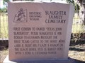 view gallery view gallery NW45.2 km NW45.2 km
| Slaughter Family Cemetary in Arizona Historical Markers This is stop #2 on the Pistols, Plows & Petticoats tour. posted by: leadhiker location: Arizona date approved: 06/15/2011 last visited: never |
 view gallery view galleryNW45.5 km | Snyder-Cavanaugh Shoot Out in Arizona Historical Markers This is stop #6 on the Pistols, Plows & Petticoats tour. posted by: leadhiker location: Arizona date approved: 06/15/2011 last visited: never |
 view gallery view galleryNW46.2 km |  FIRST - HIGHWAY OLDEST - FORD DEALERSHIP FIRST - HIGHWAY OLDEST - FORD DEALERSHIP
in First of its Kind First Ocean to Ocean Highway Oldest Garage(FORD Dealership). posted by: GEO*Trailblazer 1 location: Arizona date approved: 12/23/2006 last visited: 12/23/2006 |
 view gallery view galleryNW46.2 km | Becker's Transcontinental Garage -1910 in Arizona Historical Markers Springerville Oldest Ford Dealership Arizona posted by: GEO*Trailblazer 1 location: Arizona date approved: 01/14/2007 last visited: 09/19/2010 |
 view gallery view galleryNW46.2 km |  Springerville, Arizona Springerville, Arizona
in Wikipedia Entries Springerville is a high mountain ranching community, named in 1876. posted by: rjmcdonough1 location: Arizona date approved: 06/12/2022 last visited: never |
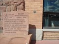
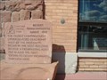
 view gallery view galleryNW46.2 km | Arizona Cooperative Mercantile Institution - Springerville, AZ in Arizona Historical Markers This marker stands alongside Main Street in front of the Arizona Cooperative Mercantile Institution. posted by: rjmcdonough1 location: Arizona date approved: 06/16/2022 last visited: never |
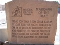 view gallery view galleryNW46.3 km | Madonna of the Trail in Arizona Historical Markers This 10 foot high, 5 ton statue cast by St. Louis sculptor August Leimbach is one of 12 identical monuments to the bold spirit of the pioneers erected in 1928-29 along the National Old Trails Road from Maryland to California. posted by: leadhiker location: Arizona date approved: 06/27/2011 last visited: 09/11/2012 |
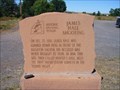 view gallery view galleryNW46.3 km | James Hale Shooting in Arizona Historical Markers On Dec. 25, 1886, James Hale was gunned down here in front of the Brighton Saloon. His accused was never brought to trial. In 1894 this site, then called Hunter's Hall, held the first Presbyterian services in the Round Valley. posted by: leadhiker location: Arizona date approved: 06/15/2011 last visited: never |
 view gallery view galleryNW46.3 km |  WWI Roll of Honor -- Springerville AZ WWI Roll of Honor -- Springerville AZ
in World War I Memorials and Monuments A somber memorial made of local petrified wood memorializes the names of those bows from Springerville AZ who dies in WWI. posted by: Benchmark Blasterz location: Arizona date approved: 09/20/2014 last visited: 09/20/2014 |
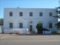 view gallery view galleryNW46.3 km |  Springerville AZ Post Office 85938 Springerville AZ Post Office 85938
in U.S. Post Offices This post office is located at 5 E Main St (US 180/191) in Springerville, AZ which is in Apache County. posted by: VQ9JC location: Arizona date approved: 08/24/2013 last visited: 09/09/2014 |
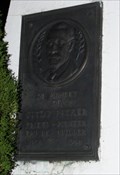 view gallery view galleryNW46.3 km |  Gustav Becker -- Springerville AZ Gustav Becker -- Springerville AZ
in Citizen Memorials A 5-foot tall obelisk memorial to Gustav Becker, in front of the Springerville AZ post office posted by: Benchmark Blasterz location: Arizona date approved: 09/10/2014 last visited: 09/12/2014 |
 view gallery view gallerySW46.3 km | Blue Vista Benchmark (Y 69) - DT0238 in U.S. Benchmarks Located in Blue Vista rest area on US191. posted by: Brad&Kim location: Arizona date approved: 09/08/2012 last visited: 05/21/2017 |
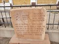
 view gallery view galleryNW46.3 km | Presbyterian & Catholic Churches - Springerville, AZ in Arizona Historical Markers Historical Driving Tour: Presbyterian & Catholic Churches - Begun as missions in the late 1800s, comunity Presbyterian church here, and St. Peters, a block east, moved into these permanent homes built respectively of brick (1918) and Adobe (1928) posted by: T2D location: Arizona date approved: 06/16/2022 last visited: never |
 view gallery view galleryNW46.3 km |  Henry's Barber Shop - Springerville, Arizona Henry's Barber Shop - Springerville, Arizona
in Barber Poles Barber pole globe is attached to the outside, roof area of the building at 11 W Main, Springerville, Arizona and above the entrance. posted by: T2D location: Arizona date approved: 07/02/2022 last visited: never |
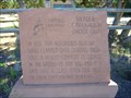
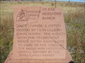
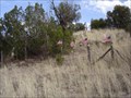 view gallery view gallery S46.7 km S46.7 km
|  W.S. Ranch Cemetery W.S. Ranch Cemetery
in Abandoned Cemeteries Located just outside of Alma, NM. Alma is north of Silver City, NM. posted by: beagle39z location: New Mexico date approved: 04/10/2007 last visited: never |
 view gallery view galleryNW47 km | 26 Bar Hereford Ranch in Arizona Historical Markers This is stop #8 on the Pistols, Plows & Petticoats driving tour. posted by: leadhiker location: Arizona date approved: 06/15/2011 last visited: never |
|