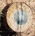
 view gallery view gallery SW13.4 km SW13.4 km
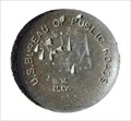
|   US BUREAU OF PUBLIC ROADS 5764.34 9 US BUREAU OF PUBLIC ROADS 5764.34 9
in U.S. Benchmarks US BUREAU OF PUBLIC ROADS BM 5764.34 9 posted by:  GEO*Trailblazer 1 GEO*Trailblazer 1 location: New Mexico date approved: 01/01/2007 last visited: 01/01/2007 |
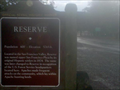 view gallery view gallerySW13.7 km |  Reserve OSHM Reserve OSHM
in New Mexico Historical Markers OSHM sign for Reserve,NM posted by:  kingbee kingbee location: New Mexico date approved: 08/19/2010 last visited: 07/02/2012 |
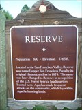 view gallery view gallerySW22.2 km | Reserve in New Mexico Historical Markers There are two OSHM's for Reserve. The other one is about 6 miles east. posted by: leadhiker location: New Mexico date approved: 06/07/2011 last visited: 07/02/2012 |
 view gallery view gallery N30.6 km N30.6 km
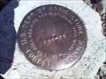
| ABR-28 U. S. Dept. of Agriculture Forest Service - Fox Mt. in U.S. Benchmarks Forest Service Marker ABR-28 is located approximately 26 miles south of Quemado, NM, on Fox Mountain. posted by: Hawikuh location: New Mexico date approved: 08/23/2009 last visited: never |
 view gallery view gallery NE40.1 km NE40.1 km
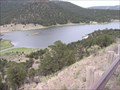
|  Quemado Lake Quemado Lake
in Campgrounds Man made lake in the Apache National Forrest in north central NM. The lake is at 7692 ft and is nice n cool in the mid summer. Fishing for rainbow trout in normally better in the late spring or early Summer. Boat with electric motors are allowed. posted by: singleshot54 location: New Mexico date approved: 06/18/2012 last visited: never |
 view gallery view gallery W43.1 km W43.1 km
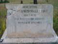
|  The Old Bushvalley Fort The Old Bushvalley Fort
in Arizona Historical Markers A marker just outside the town of Alpine along US-180. posted by: leadhiker location: Arizona date approved: 06/07/2011 last visited: never |
 view gallery view gallery S50.4 km S50.4 km
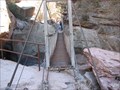
|  Whitewater Creek - Glenwood, New Mexico Whitewater Creek - Glenwood, New Mexico
in Pedestrian Suspension Bridges Old pedestrian suspension bridge spanning Whitewater Creek at the upper end of the Catwalk National Recreation Trail. posted by: linkys location: New Mexico date approved: 04/06/2008 last visited: 05/18/2011 |
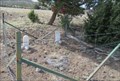
 view gallery view gallerySW50.5 km |  W.S. Ranch Cemetery W.S. Ranch Cemetery
in Abandoned Cemeteries Located just outside of Alma, NM. Alma is north of Silver City, NM. posted by: beagle39z location: New Mexico date approved: 04/10/2007 last visited: never |
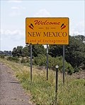 view gallery view gallery NW53.3 km NW53.3 km
|  Welcome to New Mexico - New Mexico Arizona Border Welcome to New Mexico - New Mexico Arizona Border
in Welcome Signs This sign, on the south side of U.S. 60, welcomes travelers to the Land of Enchantment. posted by: rjmcdonough1 location: New Mexico date approved: 08/26/2020 last visited: never |
 view gallery view galleryNW53.3 km | Arizona Highway Dept. 1960 - Springerville, AZ in U.S. Benchmarks This marker sits just inside Arizona's border with New Mexico. posted by: rjmcdonough1 location: Arizona date approved: 08/26/2020 last visited: never |
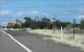 view gallery view galleryNW53.3 km |  AZ-NM US Hwy 60 - east of Springerville AZ AZ-NM US Hwy 60 - east of Springerville AZ
in Border Crossings This Border Crossing is between Arizona and New Mexico on U.S. Hwy 60 about 14 miles east of Springerville, Arizona. posted by: PeterNoG location: New Mexico date approved: 10/06/2017 last visited: 08/19/2020 |
 view gallery view gallerySW54.1 km | Mogollon in New Mexico Historical Markers The name, Mogollon, prominent in the topography and history of the southwest, is attached to both the mountains and a ghost town in this area of New Mexico. posted by: linkys location: New Mexico date approved: 12/17/2009 last visited: 01/24/2015 |
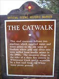 view gallery view galleryS57.8 km | The Catwalk in New Mexico Historical Markers A New Mexico OSHM near Glenwood on US-180. posted by: leadhiker location: New Mexico date approved: 06/07/2011 last visited: never |
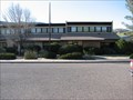 view gallery view galleryS59.1 km |  Glenwood Ranger Station - Gila National Forest Glenwood Ranger Station - Gila National Forest
in Ranger Stations US Forest Service Ranger District in southwestern New Mexico that includes the Catwalk National Recreation Area. posted by: linkys location: New Mexico date approved: 03/31/2008 last visited: never |
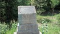
 view gallery view galleryN59.4 km |  Curtis Family Gravesite - Quemado NM Curtis Family Gravesite - Quemado NM
in Worldwide Cemeteries This very small cemetery is on the south side of US Hwy 60 about four miles west of Quemado, New Mexico. posted by: PeterNoG location: New Mexico date approved: 10/04/2017 last visited: 02/04/2017 |
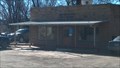 view gallery view galleryN61.5 km |  Quemado, NM 87829 Quemado, NM 87829
in U.S. Post Offices Just a wide spot in the road.... posted by: DnRseekers location: New Mexico date approved: 03/04/2016 last visited: 04/02/2017 |
 view gallery view galleryN61.5 km |  Quemado, NM Quemado, NM
in Wikipedia Entries Quemado is a census designated place in the mountains of western New Mexico. posted by: rjmcdonough1 location: New Mexico date approved: 08/26/2020 last visited: never |
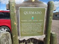
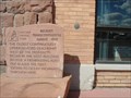
 view gallery view galleryN61.5 km | Quemado, Quemado NM in New Mexico Historical Markers This New Mexico Historical Marker is on US Hwy 60 on the west side of Quemado, New Mexico. posted by: PeterNoG location: New Mexico date approved: 03/16/2018 last visited: 08/18/2020 |
 view gallery view galleryN61.5 km |  Quemado NM pop 1,028 Quemado NM pop 1,028
in Population Signs This Population Sign is on US Hwy 60 on the west side of Quemado, New Mexico. posted by: PeterNoG location: New Mexico date approved: 04/06/2018 last visited: 08/18/2020 |
 view gallery view galleryN61.5 km |  Quemado NM 6,890 ft Quemado NM 6,890 ft
in Elevation Signs This Elevation Sign is on US Hwy 60 on the west side of Quemado, New Mexico. posted by: PeterNoG location: New Mexico date approved: 03/16/2018 last visited: 08/18/2020 |
 view gallery view galleryW64.2 km |  Clifton-Springerville Highway Marker - Coronado Trail Scenic Byway - Arizona Clifton-Springerville Highway Marker - Coronado Trail Scenic Byway - Arizona
in National Scenic Byways An historical marker commemorating the construction of the Clifton-Springerville Highway in 1926. This marker is along the Coronado Trail Scenic Byway. posted by: adenium location: Arizona date approved: 07/08/2012 last visited: 05/19/2022 |
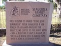 view gallery view galleryNW66.8 km | Slaughter Family Cemetary in Arizona Historical Markers This is stop #2 on the Pistols, Plows & Petticoats tour. posted by: leadhiker location: Arizona date approved: 06/15/2011 last visited: never |
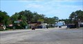
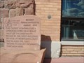 view gallery view galleryNW67.4 km |  FIRST - HIGHWAY OLDEST - FORD DEALERSHIP FIRST - HIGHWAY OLDEST - FORD DEALERSHIP
in First of its Kind First Ocean to Ocean Highway Oldest Garage(FORD Dealership). posted by: GEO*Trailblazer 1 location: Arizona date approved: 12/23/2006 last visited: 12/23/2006 |
 view gallery view galleryNW67.4 km | Becker's Transcontinental Garage -1910 in Arizona Historical Markers Springerville Oldest Ford Dealership Arizona posted by: GEO*Trailblazer 1 location: Arizona date approved: 01/14/2007 last visited: 09/19/2010 |
 view gallery view galleryNW67.6 km | Springerville, Arizona in Wikipedia Entries Springerville is a high mountain ranching community, named in 1876. posted by: rjmcdonough1 location: Arizona date approved: 06/12/2022 last visited: never |
|