  SE0.2 km SE0.2 km
|   E2 Coffee E2 Coffee
in Independent Coffee Shops east atlanta staple for getting your caffeine fix posted by:  selector23 selector23 location: Georgia date approved: 01/14/2006 last visited: never |
 view gallery view gallery E0.2 km E0.2 km
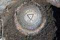
|  DG0147 - Moreland Avenue & Ormewood - Atlanta, GA DG0147 - Moreland Avenue & Ormewood - Atlanta, GA
in U.S. Benchmarks Located in the sidewalk under a cast iron cover labeled USC&GS on the east side of Moreland Ave. between Pickens St and Ormewood Ave. posted by: Lat34North location: Georgia date approved: 04/11/2010 last visited: 04/11/2010 |
 view gallery view gallery NE0.3 km NE0.3 km
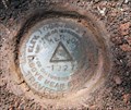
| DG0146 - Moreland Ave. & Emerson Ave. - Atlanta, GA in U.S. Benchmarks Located in the sidewalk under a cast iron cover labeled USC&GS on the east side of Moreland Ave. at the intersection with Emerson Street. posted by: Lat34North location: Georgia date approved: 04/11/2010 last visited: 04/11/2010 |
 view gallery view gallery S0.3 km S0.3 km
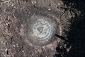
| DG0148 - Delaware Ave and Woodland Ave – Atlanta, GA in U.S. Benchmarks Located in the sidewalk under a cast iron cover labeled USC&GS on the south side of Delaware Ave just east of the intersection with Woodland Ave. posted by: Lat34North location: Georgia date approved: 04/11/2010 last visited: 04/11/2010 |
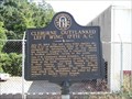
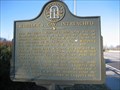
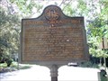
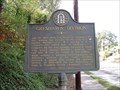
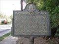
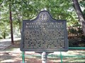 view gallery view galleryNE0.3 km |  Maney's Division in the Battle of Atlanta - GHM 044-63 – DeKalb Co., GA. Maney's Division in the Battle of Atlanta - GHM 044-63 – DeKalb Co., GA.
in Georgia Historical Markers Maney's Division in the Battle of Atlanta State Historical Marker
located on the north side of Pendleton St. in Joseph E. Brown Park in East Atlanta.
posted by: Lat34North location: Georgia date approved: 10/16/2007 last visited: 10/01/1999 |
 view gallery view gallery SW0.5 km SW0.5 km
| DG0149 - Delaware Ave - Atlanta, GA in U.S. Benchmarks Located in the sidewalk under a cast iron cover labeled USC&GS on the north side of Delaware Ave between Delaware and Eastwood Avenues. posted by: Lat34North location: Georgia date approved: 04/11/2010 last visited: 04/11/2010 |
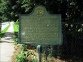
 view gallery view galleryNE0.8 km | Cleburne Outflanked Left Wing, 17th A.C. - GHM 044-64 – DeKalb Co., GA. in Georgia Historical Markers Cleburne Outflanked Left Wing, 17th A.C State Historical Marker
Located on Haas Avenue north of Glenwood Ave, East Atlanta.
posted by: Lat34North location: Georgia date approved: 10/16/2007 last visited: 10/01/1999 |
 view gallery view galleryE1 km | Cleburne's & Maney's Divs-GHM 044-62-DeKalb Co in Georgia Historical Markers Flat Shoals at Ormewood Ave (S of Glenwood), East Atlanta posted by: Sprinterman location: Georgia date approved: 08/02/2009 last visited: 10/01/1999 |
 view gallery view gallerySW1 km | To Robert Burns - Fulton, Co., GA in Georgia Historical Markers To Robert Burns historic marker located at Burns Cottage, 988 Alloway, Atlanta, GA. The marker is mounted on the side of the building. There is a gravel parking area next to the Burns Cottage.
posted by: Lat34North location: Georgia date approved: 08/08/2008 last visited: 08/07/2008 |
 view gallery view gallerySW1 km |  Burns Cottage - Atlanta, GA Burns Cottage - Atlanta, GA
in U.S. National Register of Historic Places The Robert Burns Cottage is located at 988 Alloway Pl, Atlanta, GA. Burns Cottage is privately owned by the Burns Club of Atlanta, and generally not open to the public. For more information contact Dr. James Powell, at 770-471-0725 posted by: Lat34North location: Georgia date approved: 08/09/2008 last visited: 12/19/2017 |
 view gallery view gallery N1.1 km N1.1 km
| Wheeler's Cav. Intrenched - GHM 044-66 in Georgia Historical Markers Part of the Battle of Atlanta. posted by:  ChapterhouseInc ChapterhouseInc location: Georgia date approved: 02/11/2007 last visited: 10/01/1999 |
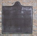
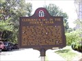 view gallery view galleryNE1.1 km | Cleburne's Division in the Federal Rear - GHM 044-65 – DeKalb Co., GA. in Georgia Historical Markers Cleburne's Division in the Federal Rear State Historical Marker
Located at Patterson and Metropolitan Aves. in East Atlanta.
posted by: Lat34North location: Georgia date approved: 10/16/2007 last visited: 10/15/2007 |
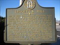 view gallery view galleryN1.1 km | Leggett's Hill in Georgia Historical Markers The major engagement of the Atlanta Campaign. posted by: ChapterhouseInc location: Georgia date approved: 02/11/2007 last visited: 10/01/1999 |
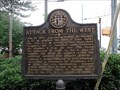 view gallery view galleryN1.3 km | Attack from the West - GHM 060-104 - Fulton Co., GA in Georgia Historical Markers Attack from the West state historic marker located at Memorial Drive and Stovall Street. posted by: Lat34North location: Georgia date approved: 08/08/2008 last visited: 10/31/2000 |
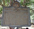 view gallery view galleryNE1.3 km | Death of McPherson - GHM 044-45 – DeKalb Co., GA in Georgia Historical Markers Death of McPherson State Historical Marker located at the McPherson Monument at McPherson and Monument Aves. in East Atlanta. posted by: Lat34North location: Georgia date approved: 10/16/2007 last visited: 10/01/1999 |
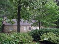
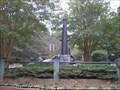 view gallery view galleryNE1.3 km |  Maj. Gen. James B. McPherson U.S. - Atlanta, GA Maj. Gen. James B. McPherson U.S. - Atlanta, GA
in Specific Veteran Memorials The monument in the enclosure was erected by U.S. Army Engineers to mark the site where Maj. Gen. James B. McPherson was killed during the Battle of Atlanta, July 22, 1864. posted by: GA Cacher location: Georgia date approved: 10/16/2007 last visited: 10/15/2007 |
 view gallery view galleryNE1.3 km | Historic Ground -- 1864 - GHM 044-68 – DeKalb Co., GA in Georgia Historical Markers Historic Ground - 1864 State Historical Marker located at the McPherson Monument at McPherson and Monument Aves. in East Atlanta. posted by: Lat34North location: Georgia date approved: 10/16/2007 last visited: 10/01/1999 |
 view gallery view gallery NW1.4 km NW1.4 km
|  Atlanta & West Point Railroad Freight Depot - Atlanta, Georgia Atlanta & West Point Railroad Freight Depot - Atlanta, Georgia
in Train Stations/Depots This modestly attractive railroad depot was constructed in the late 1920s to serve the freight businesses that established themselves along the 5.5 mile Atlanta Belt Line Railroad, a leasee of the A&WP. posted by: Bluejacket01 location: Georgia date approved: 07/17/2008 last visited: never |
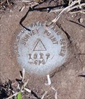 view gallery view galleryE1.4 km | AI6829 - Flatshoals Ave. – Atlanta, GA in U.S. Benchmarks Located in a grassy field at the point where Flatshoals Ave and Bouldercrest Road split. There is a witness post, the station is about 3 ft behind the witness post. posted by: Lat34North location: Georgia date approved: 04/11/2010 last visited: 04/11/2010 |
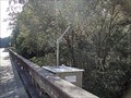 view gallery view galleryNE1.4 km |  Tallapoosa River Gage below Tallapoosa, Georgia Tallapoosa River Gage below Tallapoosa, Georgia
in River Gauges Tallapoosa River gage located on US 27, west of Tallapoosa, GA. posted by: Lat34North location: Georgia date approved: 10/21/2008 last visited: 10/15/2008 |
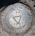 view gallery view galleryN1.6 km | DG0143 - Moreland Ave. & Kirkwood - Atlanta, GA in U.S. Benchmarks Located in the sidewalk under a cast iron cover labeled USC&GS on the west side of Moreland Ave. at the intersection with Kirkwood. There is a witness post next to a utility pole about 10 ft, SW of the station. posted by: Lat34North location: Georgia date approved: 04/11/2010 last visited: 04/11/2010 |
 view gallery view galleryNE1.6 km | Gresham's Division - GHM 044-43 – DeKalb Co., GA. in Georgia Historical Markers Gresham's Division State Historical Marker
located on Memorial Dr. near East Side Dr. in Atlanta.
posted by: Lat34North location: Georgia date approved: 10/16/2007 last visited: 10/01/1999 |
 view gallery view gallery W1.6 km W1.6 km
| Atlanta Fortifications - Fulton Co., GA in Georgia Historical Markers Locxated in Grant Park near Fort Walker on Boulevard, Atlanta, GA. posted by: Lat34North location: Georgia date approved: 06/05/2009 last visited: 06/06/2007 |
 view gallery view galleryNE1.8 km | McPherson's Last Ride - GHM 044-44 – DeKalb Co., GA. in Georgia Historical Markers McPherson's Last Ride State Historical Marker
located on Memorial Dr. near East Side Dr. in Atlanta.
posted by: Lat34North location: Georgia date approved: 10/16/2007 last visited: 10/01/1999 |
 view gallery view galleryW1.8 km |  Playground at Grant Park - Atlanta, GA. Playground at Grant Park - Atlanta, GA.
in Public Playgrounds Small play ground located on the east side of Grant Park, just south of the east parking lot. posted by: Lat34North location: Georgia date approved: 08/05/2007 last visited: 09/24/2015 |
|