 view gallery view gallery S5 km S5 km
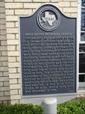
|   Methodist Episcopal Church of Douglassville Methodist Episcopal Church of Douglassville
in Texas Historical Markers Located near the front door of the church. posted by:  txoilgas txoilgas location: Texas date approved: 12/03/2009 last visited: 08/26/2014 |
 view gallery view galleryS5 km | Douglassville Baptist Church in Texas Historical Markers Located near the entrance of the church. posted by: txoilgas location: Texas date approved: 12/04/2009 last visited: 06/14/2019 |
 view gallery view gallery N10.3 km N10.3 km
|  Maud, TX - Population 1056 Maud, TX - Population 1056
in Population Signs Maud, TX, population 1056 as of this posting. This sign is located on the south side of US 67, at the western city limit. posted by: QuarrellaDeVil location: Texas date approved: 03/09/2016 last visited: 06/13/2019 |
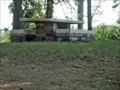
 view gallery view galleryN10.8 km |  1940 - Maud United Methodist Church - Maud, TX 1940 - Maud United Methodist Church - Maud, TX
in Dated Buildings and Cornerstones Built in 1940, the historic Maud United Methodist Church is located at 206 Main St, Maud, TX. posted by: QuarrellaDeVil location: Texas date approved: 03/10/2016 last visited: 06/03/2019 |
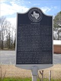
 view gallery view galleryN10.8 km |  Maud United Methodist Church - Maud, TX Maud United Methodist Church - Maud, TX
in Methodist Churches Maud United Methodist Church is located at 206 Main St, Maud, TX. posted by: QuarrellaDeVil location: Texas date approved: 03/06/2016 last visited: 06/03/2019 |
 view gallery view galleryN10.8 km | Maud United Methodist Church in Texas Historical Markers Texas Historical Marker at the Maud United Methodist Church, 206 Main St, Maud, TX, noting its organization and survival. posted by: QuarrellaDeVil location: Texas date approved: 03/06/2016 last visited: 06/03/2019 |
 view gallery view gallery E11.4 km E11.4 km
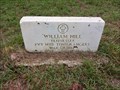
|  OLDEST Marked Grave in Old Liberty Cemetery - Cass County, TX OLDEST Marked Grave in Old Liberty Cemetery - Cass County, TX
in First of its Kind A 1997 Texas Historical Marker at Old Liberty Cemetery on FM 96 in rural Cass County, TX indicates that the oldest marked grave in the cemetery is that of William Hill, a veteran of the War of 1812 who was buried here in 1850. posted by: QuarrellaDeVil location: Texas date approved: 04/08/2024 last visited: never |
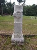 view gallery view galleryE11.6 km |  Jesse E. Griffin - Old Liberty Cemetery - Cass County, TX Jesse E. Griffin - Old Liberty Cemetery - Cass County, TX
in Woodmen of the World Grave Markers/Monuments Woodmen of the World monument for Jessie Edgar Griffin in the historic Old Liberty Cemetery on FM 96 in rural Cass County, TX. Thanks to Findagrave for information about his name. posted by: QuarrellaDeVil location: Texas date approved: 04/07/2024 last visited: never |
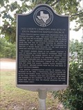 view gallery view galleryE11.6 km | Old Liberty Cemetery and Site of Enon Primitive Baptist Church in Texas Historical Markers Texas Historical Marker at the Old Liberty Cemetery on FM 96 in rural Cass County, providing some history of both this still-active cemetery as well as the church and community that once worshipped here. posted by: QuarrellaDeVil location: Texas date approved: 04/08/2024 last visited: never |
 view gallery view galleryN11.7 km | Site of Epperson's Ferry in Texas Historical Markers Gray granite 1936 Texas Centennial Marker located in Maud, TX, about seven miles from where a prominent ferry crossing was once located. posted by: QuarrellaDeVil location: Texas date approved: 03/06/2016 last visited: 06/03/2019 |
 view gallery view gallery NW15.6 km NW15.6 km
|  Bowie County Roadside Park - Simms, TX Bowie County Roadside Park - Simms, TX
in WPA Projects Park is located 1.5 miles east of Simms on US-67. posted by:  WalksfarTX WalksfarTX location: Texas date approved: 10/19/2022 last visited: never |
 view gallery view gallery NE16.1 km NE16.1 km
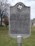
| Redwater, TX - Population 1057 in Population Signs Redwater, TX, population 1057. This sign is located on the south side of US 67, at the western city limit. posted by: QuarrellaDeVil location: Texas date approved: 03/09/2016 last visited: 06/13/2019 |
 view gallery view galleryNE17.5 km | Redwater in Texas Historical Markers Texas Historical Marker at Redwater City Hall, noting the origins and evolution of Redwater, TX. posted by: QuarrellaDeVil location: Texas date approved: 03/06/2016 last visited: 05/01/2019 |
 view gallery view galleryNW17.9 km | Athletic Field - Simms, TX in WPA Projects The newspaper article refers to a gym and athletic field. Unfortunately the gym has been demolished and replaced with a modern structure. posted by: WalksfarTX location: Texas date approved: 10/18/2022 last visited: never |
 view gallery view galleryNW17.9 km |  Pirate Stadium - Simms, TX Pirate Stadium - Simms, TX
in Illuminated School Sports Fields Field was started in 1937 when WPA was authorized to expend government money to build an athletic field and school gymnasium. posted by: WalksfarTX location: Texas date approved: 10/30/2022 last visited: never |
 view gallery view galleryNW18 km | James Bowie School - Simms, TX in WPA Projects School is still in use, it is surrounded by a matching fence, and there is a tower out back (water?). posted by: WalksfarTX location: Texas date approved: 10/18/2022 last visited: never |
 view gallery view galleryNW18 km | 1936 - James Bowie School - Simms, TX in Dated Buildings and Cornerstones School is still in use, it is surrounded by a matching fence, and there is a tower out back (water?). posted by: WalksfarTX location: Texas date approved: 10/18/2022 last visited: never |
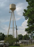 view gallery view galleryNW18 km |  Central Bowie County Water Supply Tower - Simms, Texas Central Bowie County Water Supply Tower - Simms, Texas
in Water Towers Central Bowie Water Tower in Simms, Bowie County, Texas posted by: CacheSafari location: Texas date approved: 09/02/2009 last visited: 08/30/2009 |
 view gallery view galleryNW18.2 km |  Simms, Texas 75574 Simms, Texas 75574
in U.S. Post Offices United States Post Office for Simms, Bowie County, Texas 75574 posted by: CacheSafari location: Texas date approved: 09/02/2009 last visited: 08/30/2009 |
 view gallery view galleryN19 km | Old Boston in Texas Historical Markers Texas Historical Marker noting Boston -- today's "Old Boston" -- as the original Bowie County seat, with a bit of history. This marker is located in front of a residence at the intersection of TX 8 and FM 2149. posted by: QuarrellaDeVil location: Texas date approved: 03/06/2016 last visited: never |
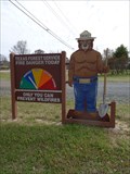 view gallery view galleryN19.3 km |  Smokey Bear - Texas A&M Forest Service - New Boston, TX Smokey Bear - Texas A&M Forest Service - New Boston, TX
in Smokey Bear Sign Sightings Smokey Bear keeps us all advised of current fire danger, standing by the highway in front of the Texas A&M Forest Service, in the 2500 block of Texas Highway 8, New Boston, TX (practically in Old Boston). posted by: QuarrellaDeVil location: Texas date approved: 03/12/2016 last visited: never |
 view gallery view gallery SE20 km SE20 km
| Law's Chapel Methodist Church in Texas Historical Markers First Protestant church in the area, founded in 1853 by Georgia pioneers George and Martha Law. posted by: techiegrl64 location: Texas date approved: 12/04/2008 last visited: 09/03/2012 |
 view gallery view gallerySE20 km | Law's Chapel Cemetery in Texas Historical Markers Located next to the Law's Chapel Methodist Church, this cemetery was started in 1854 with the burial of Henry G. Law. posted by: techiegrl64 location: Texas date approved: 12/09/2008 last visited: 03/11/2016 |
 view gallery view gallery W20.4 km W20.4 km
|  Mt. Sinai Cemetery Mt. Sinai Cemetery
in Worldwide Cemeteries A Jewish Cemetery connected to a larger city cemetery. posted by: mom2kutternkaden location: Texas date approved: 05/10/2013 last visited: never |
 view gallery view galleryW20.8 km | Oakwood Cemetery in Worldwide Cemeteries A historical cemetery located in the small Texas town of Jefferson, Texas. posted by: mom2kutternkaden location: Texas date approved: 05/10/2013 last visited: never |
|