 view gallery view gallery SE4.2 km SE4.2 km
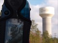
|   Goose Creek Tower Goose Creek Tower
in Water Towers This is one of the water towers in Goose Creek, SC. It's nothnig fancy, but it is a VERY visible symbol in the city. posted by:  JI Sandlappers JI Sandlappers location: South Carolina date approved: 01/02/2006 last visited: 07/23/2012 |
 view gallery view gallery S6.3 km S6.3 km
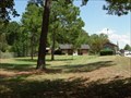
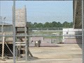
|  I26 West Rest Area - Ladson, SC I26 West Rest Area - Ladson, SC
in Highway Rest Areas Rest area on I-26 Westbound, Ladson, SC. posted by:  carolina1 carolina1 location: South Carolina date approved: 08/25/2007 last visited: 07/23/2012 |
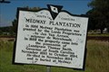 view gallery view gallerySE6.3 km |  8-19 Medway Plantation 8-19 Medway Plantation
in South Carolina Historical Markers Located on US 52 about 3.2 miles North of Goose Creek. Erected in 1965 to replace old destroyed marker. posted by:  mikemtn mikemtn location: South Carolina date approved: 09/24/2006 last visited: 07/23/2007 |
 view gallery view gallery SW6.3 km SW6.3 km
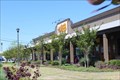
|  Cracker Barrel - I-26 Exit 199 - Summerville, SC. Cracker Barrel - I-26 Exit 199 - Summerville, SC.
in Cracker Barrel Restaurants This Cracker Barrel Old Country Store is right off I-26 at exit 199 on Hwy 17 in Summerville, Sc. posted by: BIO-HAZRD location: South Carolina date approved: 04/13/2015 last visited: 07/17/2015 |
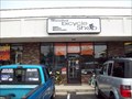 view gallery view gallerySW7.2 km |  Mainstreet Bicycle Shop - Summerville, SC Mainstreet Bicycle Shop - Summerville, SC
in Bicycle Shops A family owned and operated bicycle shop in Summerville, SC. I found it when a neighbor left a bike outside with a sign that said "FREE!" I took it, it needed some work, so I brought it here! posted by: JohnnyDingo location: South Carolina date approved: 08/08/2008 last visited: 04/20/2011 |
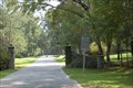
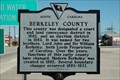 view gallery view gallerySW7.4 km | 8-22 Berkeley County in South Carolina Historical Markers Located on US 17-A at Berleley -Dorchester line, at Summerville. Erected by Berkeley County Historical Society-1976. posted by: mikemtn location: South Carolina date approved: 10/14/2006 last visited: 05/01/2008 |
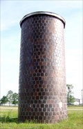 view gallery view galleryS7.7 km |  Highway 78 - Ladson, SC Highway 78 - Ladson, SC
in Solitary Silos Located in Ladson, SC. posted by: carolina1 location: South Carolina date approved: 09/04/2008 last visited: 07/23/2012 |
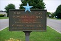
 view gallery view gallerySE8 km |  Hwy 176 and Westview Blvd, Goose Creek, South Carolina Hwy 176 and Westview Blvd, Goose Creek, South Carolina
in Blue Star Memorial Highway Markers Located at a busy intersection in Goose Creek, South Carolina. posted by: mikemtn location: South Carolina date approved: 10/15/2006 last visited: 09/19/2008 |
 view gallery view galleryS8.2 km | I-26 Eastbound in Highway Rest Areas Located on I-26 Eastbound at mile marker 204 in the Goose Creek area just West of Charleston, South Carolina. posted by: mikemtn location: South Carolina date approved: 10/15/2006 last visited: 06/05/2010 |
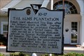 view gallery view galleryS9.5 km | HM 10-17 The Elms Plantation in South Carolina Historical Markers Near Ladson, SC posted by: carolina1 location: South Carolina date approved: 04/30/2008 last visited: 04/30/2008 |
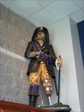 view gallery view galleryS9.5 km |  Mascot - Charleston Southern University Buccaneers Mascot - Charleston Southern University Buccaneers
in School Mascots Mascot - Charleston Southern University Buccaneers posted by: carolina1 location: South Carolina date approved: 07/12/2007 last visited: 07/13/2007 |
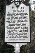 view gallery view gallerySE10.3 km | 8-54 The Oaks in South Carolina Historical Markers Located at The Oaks Ave and Middleton Drive, Goose Creek posted by: Markerman62 location: South Carolina date approved: 01/04/2020 last visited: 12/31/2019 |
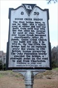 view gallery view gallerySE10.8 km | 8-59 Goose Creek Bridge in South Carolina Historical Markers Located on Old State Road just north of Goose Creek Road, Goose Creek posted by: Markerman62 location: South Carolina date approved: 01/04/2020 last visited: 12/31/2019 |
 view gallery view galleryS10.9 km |  DM3253 - DAIMLER DM3253 - DAIMLER
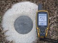
in U.S. Benchmarks NGS PID DM3253. This is a Height Modernization Survey Station. Survey disk set in top of concrete monument, Stamping: DAIMLER 2010 by the South Carolina Geodetic Survey 2010. The Marker is equipped with a bar magnet. posted by: error650 location: South Carolina date approved: 02/03/2012 last visited: 02/01/2012 |
 view gallery view gallery NE10.9 km NE10.9 km
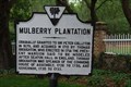
| 8-4 Mulberry Plantation in South Carolina Historical Markers Located in Berkeley County, South Carolina. posted by: carolina1 location: South Carolina date approved: 04/29/2008 last visited: 04/30/2008 |
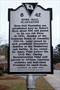 view gallery view gallerySE11.1 km | 8-42 Howe Hall Plantation/Howe Hall Elementary School in South Carolina Historical Markers Located on Howe Hall Road east of Red Bank Road in front of the school, Goose Creek posted by: Markerman62 location: South Carolina date approved: 01/04/2020 last visited: 12/31/2019 |
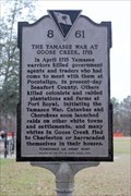 view gallery view gallerySE11.7 km | 8-61 The Yamasee War at Goose Creek, 1715 in South Carolina Historical Markers Located in Foster Creek Park on Foster Creek Road, Goose Creek posted by: Markerman62 location: South Carolina date approved: 01/04/2020 last visited: 12/31/2019 |
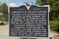 view gallery view galleryNE13.7 km | 8-16 Lewisfield Plantation in South Carolina Historical Markers Located about 1 mile SW of Monks Corner. Erected by Berkley County Historical Society-1978. posted by: mikemtn location: South Carolina date approved: 09/24/2006 last visited: 04/23/2008 |
 view gallery view galleryS14.2 km | Eagle Landing Boulevard - Charleston, SC in Blue Star Memorial Highway Markers Blue Star in Charleston, South Carolina. posted by: carolina1 location: South Carolina date approved: 06/06/2008 last visited: 06/07/2008 |
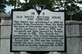 view gallery view gallerySW14.5 km | 18-5 Old White Meeting House and Cemetery in South Carolina Historical Markers Located in the Summerville, South Carolina area. Erected by Summerville Presbyterian Church-1996. This site is also listed on the National Register of Historic Places. posted by: mikemtn location: South Carolina date approved: 09/17/2006 last visited: 09/27/2007 |
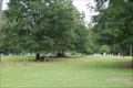 view gallery view gallerySW14.5 km |  Old White Meeting House Ruins and Cemetery Old White Meeting House Ruins and Cemetery
in U.S. National Register of Historic Places Located near Summerville, South Carolina. posted by: mikemtn location: South Carolina date approved: 09/17/2006 last visited: 09/27/2007 |
 view gallery view gallerySW14.5 km | Old Dorchester in U.S. National Register of Historic Places Located at Dorchester State Park near Summerville, South Carolina. posted by: mikemtn location: South Carolina date approved: 09/17/2006 last visited: 09/27/2007 |
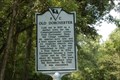 view gallery view gallerySW14.5 km | 18-1 Old Dorchester in South Carolina Historical Markers Located at Dorchester State Park off SC 642. Erected by S.C. State Commission of Forestry, Division of State Parks-1963. posted by: mikemtn location: South Carolina date approved: 09/17/2006 last visited: 11/12/2005 |
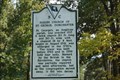 view gallery view gallerySW14.6 km | 18-2 Parish Church of St. George, Dorchester in South Carolina Historical Markers Located at Dorchester State Park off SC 462. Erected by S.C. State Commission of Forestry, Division of State Parks-1963. posted by: mikemtn location: South Carolina date approved: 09/17/2006 last visited: 11/12/2005 |
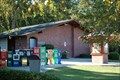
 view gallery view galleryS14.6 km |  Courtyard Skatepark - North Charleston, South Carolina Courtyard Skatepark - North Charleston, South Carolina
in Skateparks Courtyard Skate park in N. Charleston, South Carolina. posted by: carolina1 location: South Carolina date approved: 08/23/2007 last visited: 09/16/2007 |
|