 view gallery view gallery N6.6 km N6.6 km
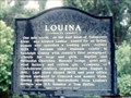
|   Louina Louina
in Alabama Historical Markers On AL 22 just east of the Tallapoosa River bridge. posted by:  Markerman62 Markerman62 location: Alabama date approved: 03/22/2015 last visited: 03/11/2015 |
 view gallery view gallery W9.8 km W9.8 km
| Daviston, Alabama - Daviston, AL in Alabama Historical Markers Daviston, Alabama, incorporated February 16, 1887, is believed to be the first incorporated rural town in Tallapoosa County. posted by: hummerstation location: Alabama date approved: 02/25/2016 last visited: never |
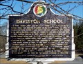 view gallery view galleryW9.8 km | Daviston School - Daviston, AL in Alabama Historical Markers At the time of its closing in 1988 Daviston School was the smallest school in Alabama with 120 K-12 students. posted by: hummerstation location: Alabama date approved: 02/25/2016 last visited: never |
 view gallery view gallery E17.9 km E17.9 km
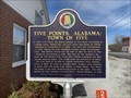
| Five Points, Alabama: Town of Five - Five Points, AL in Alabama Historical Markers Located on US 431 in front of Five Points Town Hall posted by: Markerman62 location: Alabama date approved: 03/30/2022 last visited: never |
 view gallery view galleryE17.9 km | First Consolidated High School in the State of Alabama - Five Points, AL in Alabama Historical Markers Located on US 431 at County Road 222, Five Points posted by: Markerman62 location: Alabama date approved: 03/30/2022 last visited: never |
 view gallery view gallery NE18.2 km NE18.2 km
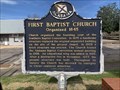
| First Baptist Church Organized 1845 - Roanoke, AL in Alabama Historical Markers Located on Main Street and Church Street, Roanoke posted by: Markerman62 location: Alabama date approved: 03/30/2022 last visited: never |
 view gallery view gallery SE20.3 km SE20.3 km
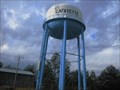
|  LaFayette, Alabama - water tower LaFayette, Alabama - water tower
in Water Towers Water Tower posted by:  Sharpslaw Sharpslaw location: Alabama date approved: 12/15/2007 last visited: never |
 view gallery view gallery SW20.4 km SW20.4 km
|  Battle of Horseshoe Bend -- Creek Indian War, Daviston AL Battle of Horseshoe Bend -- Creek Indian War, Daviston AL
in Battlefields The site of the Battle of Horseshoe Bend during Creek Indian War, at Daviston AL posted by: Benchmark Blasterz location: Alabama date approved: 10/05/2017 last visited: 11/22/2023 |
 view gallery view gallerySW20.4 km |  Long Roll Beating / Charge! / Designed for Defense -- Horseshoe Bend NMP, Daviston AL Long Roll Beating / Charge! / Designed for Defense -- Horseshoe Bend NMP, Daviston AL
in Signs of History Three signs of history located together at the site of the Red Stick Breastwork on the Battle of Horsehoe Bend battlefield posted by: Benchmark Blasterz location: Alabama date approved: 09/04/2017 last visited: 07/26/2017 |
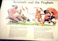 view gallery view gallerySW20.4 km | Tecumseh and the Prophets - Daviston AL in Signs of History In 1811 Tecumseh, a Shawnee Indian tapped the growing resentment within the Creek Nation. posted by: Don.Morfe location: Alabama date approved: 11/07/2020 last visited: 09/24/2021 |
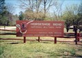
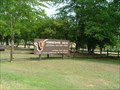 view gallery view gallerySW20.4 km |  Horseshoe Bend NMP Horseshoe Bend NMP
in NPS Passport Cancellation Stations In the spring of 1814, General Andrew Jackson and an army of 3,300 men attacked 1,000 Upper Creek warriors on the Tallapoosa River. Over 800 Upper Creeks died defending their homeland. Never before or since in the history of our country have so many American Indians lost their lives in a single battle. This 2040-acre park preserves the site of the battle.
posted by: tiki-4 location: Alabama date approved: 08/19/2007 last visited: 12/07/2021 |
 view gallery view gallerySW20.4 km | ") Horseshoe Bend NMP Horseshoe Bend NMP
in National Parks (U.S.) In the spring of 1814, General Andrew Jackson and an army of 3,300 men attacked 1,000 Upper Creek warriors on the Tallapoosa River. Over 800 Upper Creeks died defending their homeland. Never before or since in the history of our country have so many American Indians lost their lives in a single battle. This 2040-acre park preserves the site of the battle.
posted by: tiki-4 location: Alabama date approved: 08/18/2007 last visited: 02/09/2022 |
 view gallery view gallerySW20.4 km |  Horseshoe Bend Cannon - Horseshoe Bend State Park, AL Horseshoe Bend Cannon - Horseshoe Bend State Park, AL
in Static Artillery Displays These cannons were used to bombard a Native American village in 1814 by General Andrew Jackson posted by: riston2 location: none listed yet date approved: 05/20/2010 last visited: 03/01/2019 |
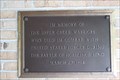
 view gallery view gallerySW20.4 km |  Creek Indian War Memorial -- Horseshoe Bend NMP, Daviston AL USA Creek Indian War Memorial -- Horseshoe Bend NMP, Daviston AL USA
in Specific Wars Monuments and Memorials A plaque at the entrance to the Visitor Center at Horseshoe Bend National Military Park honors Creek warriors, US Soldiers, and their Indian allies who died in the Creek War of 1813-14 posted by: Benchmark Blasterz location: Alabama date approved: 09/04/2017 last visited: 07/26/2017 |
 view gallery view gallerySW20.4 km |  Soldiers and Indian Allies Who Died with Upper Creeks -- Horseshoe Bend NMP, Daviston AL Soldiers and Indian Allies Who Died with Upper Creeks -- Horseshoe Bend NMP, Daviston AL
in Non-Specific Veteran Memorials A small memorial plaque at the entrance to the Visitor Center at Horseshoe Bend National Military Park honors US Soldiers and other Indian allies who died in the Creek War posted by: Benchmark Blasterz location: Alabama date approved: 09/05/2017 last visited: 07/26/2017 |
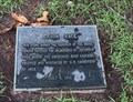
 view gallery view gallerySW20.4 km | Creek Warriors Who Died in Battle at Horseshoe Bend -- Horseshoe Bend NMP, Daviston AL in Non-Specific Veteran Memorials A small memorial plaque at the entrance to the Visitor Center at Horseshoe Bend National Military Park honors Creek warriors who died in the battle of Horseshoe Bend, near Daviston AL in 1814 posted by: Benchmark Blasterz location: Alabama date approved: 09/05/2017 last visited: 07/26/2017 |
 view gallery view gallerySW20.9 km |  MAJ Lemuel P. Montgomery MAJ Lemuel P. Montgomery
in Out of Place Graves Horseshoe Bend first casuality. posted by: tiki-4 location: Alabama date approved: 08/20/2007 last visited: 12/07/2021 |
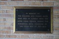
 view gallery view gallerySW20.9 km | End of the Jackson Trace -- Horseshoe Bend NMP, Daviston AL in Signs of History A small plaque from 1914 at the end of the Jackson Trace posted by: Benchmark Blasterz location: Alabama date approved: 09/04/2017 last visited: 07/26/2017 |
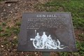 view gallery view gallerySW20.9 km | Gun Hill -- Horseshoe Bend NMP, Daviston AL in Signs of History A sign of history at Horseshoe Bend National Military Park, near Daviston AL posted by: Benchmark Blasterz location: Alabama date approved: 09/04/2017 last visited: 12/07/2021 |
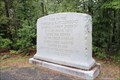 view gallery view gallerySW20.9 km | Site of Horseshoe Battleground -- Horseshoe Bend NMP, Daviston AL in Signs of History A sign of history at Horseshoe Bend National Military Park, near Daviston AL posted by: Benchmark Blasterz location: Alabama date approved: 09/04/2017 last visited: 12/07/2021 |
 view gallery view gallerySW20.9 km |  Site of Horseshoe Battleground -- Horseshoe Bend NMP, Daviston AL Site of Horseshoe Battleground -- Horseshoe Bend NMP, Daviston AL
in Human Error A sign of history at Horseshoe Bend National Military Park, near Daviston AL with the WRONG DATE OF THE BATTLE! Doh! posted by: Benchmark Blasterz location: Alabama date approved: 09/08/2017 last visited: 12/07/2021 |
 view gallery view gallerySW21.1 km | They Fought to the Last -- Horseshoe Bend NMP, Daviston AL in Signs of History A sign of history at Horseshoe Bend National Military Park, near Daviston AL posted by: Benchmark Blasterz location: Alabama date approved: 09/04/2017 last visited: 07/26/2017 |
 view gallery view gallerySW21.1 km | Futile Escape -- Horseshoe Bend NMP, Daviston AL in Signs of History A sign of history at Horseshoe Bend National Military Park, near Daviston AL posted by: Benchmark Blasterz location: Alabama date approved: 09/04/2017 last visited: 07/26/2017 |
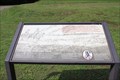
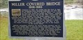 view gallery view gallerySW21.2 km | Miller Covered Bridge in Alabama Historical Markers Miller Covered Bridge was one of the longest bridges in the U.S. and is located in Horseshoe Bend National Military Park. posted by: Blazer3T location: Alabama date approved: 04/13/2020 last visited: 05/21/2023 |
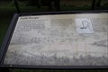
 view gallery view gallerySW21.2 km |  Horseshoe Bend National Military Park - Daviston AL Horseshoe Bend National Military Park - Daviston AL
in Satellite Imagery Oddities Horseshoe Bend National Military Park is a 2,040-acre, U.S. national military park managed by the National Park Service that is the site of the last battle of the Creek War on March 27, 1814. posted by: Don.Morfe location: Alabama date approved: 02/09/2022 last visited: 02/09/2022 |
|