 view gallery view gallery E7.2 km E7.2 km
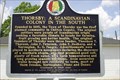
|   THORSBY: A SCANDINAVIAN COLONY IN THE SOUTH THORSBY: A SCANDINAVIAN COLONY IN THE SOUTH
in Alabama Historical Markers Historical marker describing the origins of the Town of Thorsby posted by:  OHail OHail location: Alabama date approved: 05/15/2013 last visited: 04/25/2014 |
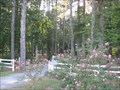
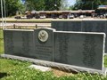 view gallery view galleryE7.6 km |  Thorsby Remembers Our Veterans - Thorsby, AL Thorsby Remembers Our Veterans - Thorsby, AL
in Non-Specific Veteran Memorials Located in the rural central Alabama city of Thorsby, this memorial honors veterans of this Chilton County area. posted by:  hoteltwo hoteltwo location: Alabama date approved: 04/27/2014 last visited: never |
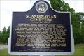 view gallery view galleryE7.6 km | Scandinavian Cemetery in Alabama Historical Markers Marker describing the history of the area and the cemetery posted by: OHail location: Alabama date approved: 05/15/2013 last visited: 04/25/2014 |
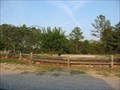
 view gallery view galleryE9.3 km |  Welcome to Thorsby, a Scandinavian settlement Welcome to Thorsby, a Scandinavian settlement
in Welcome Signs Sign on the south side of Thorsby welcoming northbound US 31 travelers to the Town of Thorsby posted by: OHail location: Alabama date approved: 05/16/2013 last visited: never |
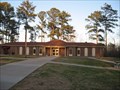
 view gallery view galleryE11.3 km |  Collins Chapel Community Park - Chapel Hill, AL Collins Chapel Community Park - Chapel Hill, AL
in Municipal Parks and Plazas Small park with walking track sitting area and picnic tables posted by: Lazer location: Alabama date approved: 09/21/2007 last visited: 08/27/2009 |
 view gallery view galleryE14.5 km |  Clanton Drive-In, Clanton, AL Clanton Drive-In, Clanton, AL
in Closed Drive-In Theatres About all that is left of this drive-in is a deteriorating screen and marquee. posted by: xptwo location: Alabama date approved: 10/28/2012 last visited: never |
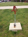 view gallery view galleryE14.8 km |  I-65 SB Rest Area - Clanton, Alabama I-65 SB Rest Area - Clanton, Alabama
in Hand Operated Water Pumps A Woodford IOWA hand operated water pump in the rest area near Clanton, Alabama. posted by: theHostas location: Alabama date approved: 04/26/2019 last visited: 03/30/2019 |
 view gallery view galleryE14.8 km |  I-65 Southbound MM 213 - Clanton, Alabama I-65 Southbound MM 213 - Clanton, Alabama
in Highway Rest Areas Located at mile marker 213, this Chilton County Rest Area is near Clanton, Alabama, and is maintained by the State of Alabama. posted by: xptwo location: Alabama date approved: 02/06/2012 last visited: 03/29/2019 |
 view gallery view galleryE15.1 km | I-65 Northbound MM 213 - Clanton, Alabama in Highway Rest Areas Located at mile marker 213, this Chilton County Rest Area is near Clanton, Alabama, and is maintained by the State of Alabama. posted by: xptwo location: Alabama date approved: 02/06/2012 last visited: never |
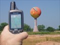
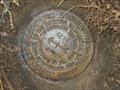
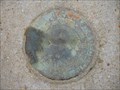 view gallery view gallery SE15.3 km SE15.3 km
|  Peach Azimuth (CN2966) - Clanton, Alabama Peach Azimuth (CN2966) - Clanton, Alabama
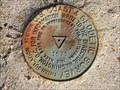
in Azimuth Benchmarks The azimuth disk part of the Peach triangulation station disk is located on County Road 76 next to a driveway. It stands out clearly as the concrete extends above ground, and it is next to a witness post. posted by: xptwo location: Alabama date approved: 11/03/2012 last visited: never |
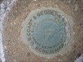
 view gallery view gallerySE15.6 km |  Clanton Triangulation (CN3233) - Clanton, AL Clanton Triangulation (CN3233) - Clanton, AL
in U.S. Benchmarks This mark is located in front of Trinity Bible Church in Clanton, Alabama. It is easy to spot as the concrete post rises above the ground. posted by: xptwo location: Alabama date approved: 11/24/2012 last visited: never |
 view gallery view gallerySE15.8 km | Clanton West Municipal Tank (CN2964) - Clanton, AL in U.S. Benchmarks The West Municipal Tower is located on the west side of Clanton, Alabama. It is possibly the shortest tower in the area. posted by: xptwo location: Alabama date approved: 11/23/2012 last visited: never |
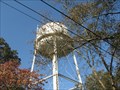
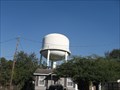 view gallery view gallerySE15.8 km |  Clanton West Municipal Tower - Clanton, AL Clanton West Municipal Tower - Clanton, AL
in Water Towers The West Municipal Tank is located on the west side of Clanton, Alabama. It is possibly the shortest tower in the area. posted by: xptwo location: Alabama date approved: 12/23/2012 last visited: never |
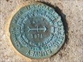 view gallery view gallerySE15.8 km | Clanton Azimuth (CN3238) - Clanton, AL in U.S. Benchmarks This azimuth mark is located on a street corner in a neighborhood in Clanton, Alabama. It can be found at the northeast corner of the intersection of 4th Avenue North and Hannah Street. posted by: xptwo location: Alabama date approved: 10/30/2012 last visited: never |
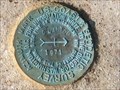 view gallery view gallerySE15.8 km | Clanton Azimuth (CN3238) - Clanton, AL in Azimuth Benchmarks This azimuth mark is located on a street corner in a neighborhood in Clanton, Alabama. It can be found at the northeast corner of the intersection of 4th Avenue North and Hannah Street. posted by: xptwo location: Alabama date approved: 10/27/2012 last visited: never |
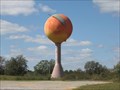 view gallery view galleryE16.1 km |  Big Peach Water Tower - Clanton, Alabama Big Peach Water Tower - Clanton, Alabama
in Roadside Attractions Chilton County is famous for their peaches, so they decided to celebrate that fact with a peach of a water tower. It can be seen from I-65 and certainly gets attention. posted by: xptwo location: Alabama date approved: 10/13/2012 last visited: 06/24/2023 |
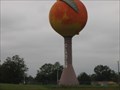 view gallery view galleryE16.3 km |  Clanton Giant Peach Clanton Giant Peach
in Ginormous Everyday Objects Clanton is known for its giant peach-shaped water tower (a similar water tower can be found in Gaffney, South Carolina). posted by: JacobBarlow location: Alabama date approved: 01/22/2008 last visited: 06/24/2023 |
 view gallery view galleryE16.3 km | AL's Big Peach in Water Towers Heading south on I-65 take exit 212. You will see this giant fruit before you leave the interstate. Heading north you might pass the exit before you get a glimpse. Georgia and South Carolina may have similar ones but this one is ours! posted by: Frodo13 location: Alabama date approved: 08/25/2005 last visited: 06/24/2023 |
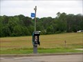 view gallery view galleryE16.4 km |  Interstate 65 Exit 212 - Chevron Payphone Interstate 65 Exit 212 - Chevron Payphone
in Payphones Nice drive-up pay phone just off the interstate in a rural area. posted by: HotRod205 location: Alabama date approved: 05/06/2010 last visited: 10/20/2011 |
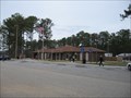
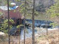 view gallery view galleryE17.1 km |  Scenic Chilton County Scenic Chilton County
in Man-made Waterfalls Old Gristmill and waterfall as well as old bridge posted by: crashdad location: Alabama date approved: 02/20/2007 last visited: 08/14/2008 |
 view gallery view gallerySE17.1 km | Goose Pond Park - Clanton, AL in Municipal Parks and Plazas A large shaded park located in Clanton, AL posted by: Lazer location: Alabama date approved: 09/21/2007 last visited: 10/27/2012 |
 view gallery view gallery NW17.2 km NW17.2 km
| MAHAN Azimuth (DH2478) - Brierfield, AL in Azimuth Benchmarks This azimuth is in Bibb County, a few miles from Montevallo, Alabama. posted by: xptwo location: Alabama date approved: 12/09/2012 last visited: never |
 view gallery view gallerySE17.2 km | Clanton Bridge (CN1263) - Clanton, AL in U.S. Benchmarks This benchmark is set in one of the concrete supports at a bridge in Clanton, Alabama. posted by: xptwo location: Alabama date approved: 11/23/2012 last visited: never |
 view gallery view gallerySE17.4 km | Clanton North Municipal Tank (CN2967) - Clanton, AL in U.S. Benchmarks The local surveyors seem to have used many of the municipal water tanks. This one is located on the north side of Canton, Alabama. posted by: xptwo location: Alabama date approved: 11/23/2012 last visited: never |
 view gallery view gallerySE17.4 km | Clanton North Municipal Tank - Clanton, AL in Water Towers This municipal water tank is located on the north side of Canton, Alabama. posted by: xptwo location: Alabama date approved: 12/12/2012 last visited: never |
|