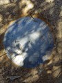
 view gallery view gallery SE7.2 km SE7.2 km
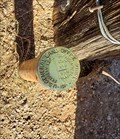
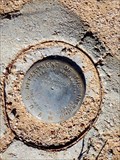
|   BM 1919 - Red Rock, AZ BM 1919 - Red Rock, AZ
in U.S. Benchmarks This pipe cap marker is in good shape and sits beside an old ranch road. posted by:  rjmcdonough1 rjmcdonough1 location: Arizona date approved: 12/13/2023 last visited: never |
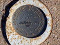
 view gallery view gallery E10.1 km E10.1 km
| T8S R 11 E S 17 S16 S 220 S 21 - Red Rock, AZ in U.S. Benchmarks This pipe cap benchmark is located at the gate to a cattle corral. posted by: rjmcdonough1 location: Arizona date approved: 01/01/2024 last visited: never |
 view gallery view gallery NE13.4 km NE13.4 km
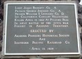
|  In Memory of Tom Mix In Memory of Tom Mix
in Arizona Historical Markers In Memory of
Tom Mix
Whose spirit left his body on this spot.
And whose characterization and portrayals
in life served to better fix memories of
the old west in the minds of living men. posted by:  leadhiker leadhiker location: Arizona date approved: 04/30/2010 last visited: 03/14/2019 |
 view gallery view gallery SW14.6 km SW14.6 km
| Mormon Battalion Trail in Arizona Historical Markers The Mormon Battalion of the U.S. Army camped here enroute to California December 17, 1846. posted by: leadhiker location: Arizona date approved: 05/06/2010 last visited: 03/04/2015 |
 view gallery view gallerySW14.6 km | Battle at Picacho in Arizona Historical Markers Dedicated to those Confederate frontiersmen who occupied Arizona Territory, C.S.A., created by President Jefferson Davis, February 14, 1862. posted by: leadhiker location: Arizona date approved: 05/03/2010 last visited: 03/04/2015 |
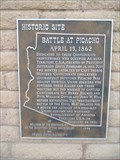
 view gallery view gallerySW14.6 km |  Battle at Picacho Battle at Picacho
in Battlefields Picacho Peak’s most noted historic event occurred on April 15, 1862, when Confederate and Union scouting parties met in the Battle of Picacho Pass during the Civil War. This was the largest Civil War clash to take place in Arizona. posted by: leadhiker location: Arizona date approved: 05/03/2010 last visited: 07/02/2018 |
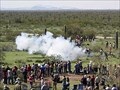 view gallery view gallerySW14.6 km |  Civil War in the Southwest - Picacho, AZ Civil War in the Southwest - Picacho, AZ
in Historic Reenactments Each year you can see a Civil War battles reenacted at Picacho Peak State Park in Picacho, AZ. posted by: Poehunters location: Arizona date approved: 08/20/2013 last visited: 03/07/2018 |
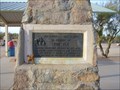
 view gallery view gallerySW14.6 km |  Memorial to the 1st California Cavalry Volunteers - Picacho, AZ Memorial to the 1st California Cavalry Volunteers - Picacho, AZ
in American Civil War Monuments and Memorials This 'westernmost battle of the Civil War' delayed for a month the advance of a 2300-man Union column and hastened establishment of Arizona Territory, U.S.A. posted by: leadhiker location: Arizona date approved: 05/02/2010 last visited: 06/20/2021 |
 view gallery view gallerySW14.6 km | Battle at Picacho Memorial, Picacho, Arizona in U.S. Civil War Sites This is a memorial to the 1st California Cavalry Volunteers who fought in the Civil War Battle at Picacho, Arizona. posted by: tugies location: Arizona date approved: 05/06/2014 last visited: 06/30/2021 |
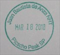 view gallery view gallerySW14.6 km |  "Juan Bautista de Anza NHT - Picacho Peak SP" - Picacho Peak State Park Visitor's Center "Juan Bautista de Anza NHT - Picacho Peak SP" - Picacho Peak State Park Visitor's Center
in NPS Passport Cancellation Stations One of the stamps for the Juan Bautista de Anza National Historic Trail can be found in Picacho Peak State Park. posted by: Rayman location: Arizona date approved: 03/31/2010 last visited: 02/13/2019 |
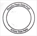 view gallery view gallerySW14.6 km |  Picacho Peak State Park - Picacho, AZ Picacho Peak State Park - Picacho, AZ
in State Park Passport Locations The visitor's center is the home of the Picacho Peak State Park stamp, part of the Arizona State Parks Passport program. posted by: Rayman location: Arizona date approved: 05/03/2010 last visited: 07/30/2021 |
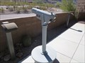 view gallery view gallerySW14.6 km |  Picacho Peak State Park Binoculars - Eloy, AZ Picacho Peak State Park Binoculars - Eloy, AZ
in Coin-Op Binoculars These binoculars are located at Picacho Peak State Park outside Eloy, AZ. posted by: rjmcdonough1 location: Arizona date approved: 10/09/2017 last visited: 07/02/2018 |
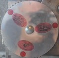 view gallery view gallerySW14.6 km |  Picacho Peak State Park Penny Smasher Picacho Peak State Park Penny Smasher
in Penny Smashers This three-design Penny Smasher is in the Picacho Peak State Park Visitor Center at Exit 219 on Interstate 10 southeast of Picacho, Arizona. posted by: brwhiz location: Arizona date approved: 10/22/2011 last visited: 10/08/2017 |
 view gallery view gallery S15 km S15 km
|  Feed the animals - Rooster Cogburn Ostrich Ranch-Picacho, AZ Feed the animals - Rooster Cogburn Ostrich Ranch-Picacho, AZ
in Feeding the Animals Feed different animals including Ostrich, Deer, Lorikeets and so many more! With the entrance fee you receive food for all the animal on the ranch..for $3 more you can get food to feed the stingrays.. posted by: grandmabetsy location: Arizona date approved: 03/07/2018 last visited: 02/14/2021 |
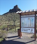 view gallery view gallerySW15 km |  Calloway Trail - Picacho Peak State Park, Arizona Calloway Trail - Picacho Peak State Park, Arizona
in Hiking and walking trailheads The Calloway Trail up Picacho Peak begins at this location. posted by: The Snowdog location: Arizona date approved: 03/21/2020 last visited: never |
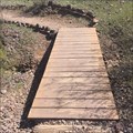 view gallery view gallerySW15.1 km |  Hunter Trail-Picacho Peak State Park, Arizona Hunter Trail-Picacho Peak State Park, Arizona
in Hiking Path Footbridges A short wooden bridge on the Hunter Trail. posted by: grandmabetsy location: Arizona date approved: 03/08/2018 last visited: 02/11/2020 |
 view gallery view gallery N15.1 km N15.1 km
| Pinal County Welcome - North in Arizona Historical Markers A missing marker, just north of the other Pinal county missing marker, but I believe it's important to document the missing markers. Maybe someone in the Pinal Historical Commission or Arizona Historical Society will take notice. posted by: unimoggers location: Arizona date approved: 10/05/2007 last visited: 10/21/2018 |
 view gallery view galleryN15.1 km | Pinal Pioneer Parkway Marker - Florence, AZ in U.S. Benchmarks This marker is at the base of the sign identifying the Pinal Pioneer Parkway, Hwy.79, south of Florence Arizona. posted by: rjmcdonough1 location: Arizona date approved: 03/28/2018 last visited: never |
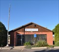 view gallery view gallery W16.7 km W16.7 km
|  Picacho, Arizona 85141 Picacho, Arizona 85141
in U.S. Post Offices This Post Office is located at 6546 E Camino Adelante in Picacho, Arizona. posted by: brwhiz location: Arizona date approved: 11/06/2011 last visited: 03/04/2015 |
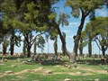 view gallery view galleryW16.9 km |  Eloy Memorial Park - Eloy, Arizona, USA Eloy Memorial Park - Eloy, Arizona, USA
in Worldwide Cemeteries This cemetery, tucked away off the highway, was established in 1955. posted by:  Tsegi Mike and Desert Viking Tsegi Mike and Desert Viking location: Arizona date approved: 09/14/2011 last visited: 08/29/2022 |
 view gallery view galleryW17.1 km |  Picacho KOA Campground, Picacho, AZ Picacho KOA Campground, Picacho, AZ
in Campgrounds A nice place to stay if you're in Picacho. It's open all year with lots of amenities. Very beautiful and friendly place to stay. posted by: Poehunters location: Arizona date approved: 08/06/2013 last visited: 06/18/2021 |
 N18.7 km |  St Anthony's Greek Orthodox Monastery St Anthony's Greek Orthodox Monastery
in Abbeys, Convents and Monasteries Only a few years old, this monastery is in the middle of the Sonoran Desert in Arizona. posted by: Tsegi Mike and Desert Viking location: Arizona date approved: 09/15/2005 last visited: 01/20/2010 |
 view gallery view galleryS19.3 km | Bureau of Reclamation Mark 381.410 - Red Rock, AZ in U.S. Benchmarks This benchmark is near the Central Arizona Project Canal near the community of Red Rock, Arizona. posted by: rjmcdonough1 location: Arizona date approved: 02/03/2018 last visited: never |
 view gallery view galleryS19.6 km | Bureau of Reclamation Benchmark 995 - Red Rock, AZ in U.S. Benchmarks This benchmark is alongside the Central Arizona Project Canal near Red Rock, AZ posted by: rjmcdonough1 location: Arizona date approved: 02/03/2018 last visited: never |
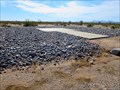 view gallery view galleryS19.6 km |  Central Arizona Project Heliport - Red Rock, AZ Central Arizona Project Heliport - Red Rock, AZ
in Helicopter Landing Pads This simple heliport is located next to the CAP canal in south central Arizona. posted by: rjmcdonough1 location: Arizona date approved: 02/05/2018 last visited: 01/12/2019 |
|