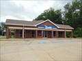
 view gallery view gallery S7.4 km S7.4 km
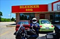
|   Bleeker BBQ- Salem, AL Bleeker BBQ- Salem, AL
in Classic BBQ and Sandwich Joints Its bleek looking for Bleeker BBQ, there ain't nothing on this joint posted by:  nomadwillie nomadwillie location: Alabama date approved: 02/18/2013 last visited: never |
 view gallery view gallery SW8.4 km SW8.4 km
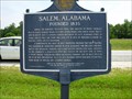
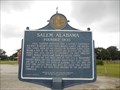
|  SALEM, ALABAMA FOUNDED 1835-HCC-Lee County SALEM, ALABAMA FOUNDED 1835-HCC-Lee County
in Alabama Historical Markers Located in front of Salem United Methodist Church on U.S. Highway 280-431, Salem, Alabama posted by:  Sprinterman Sprinterman location: Alabama date approved: 07/19/2009 last visited: 03/05/2006 |
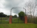 view gallery view gallerySW8.4 km |  Salem Cemetery - Salem, Alabama Salem Cemetery - Salem, Alabama
in Freestanding Arches The Freestanding Arch provides a simple announcement of the name of the cemetery and the location of the entrance to the grounds next to the Salem United Methodist Church. posted by: xptwo location: Alabama date approved: 09/25/2013 last visited: never |
 view gallery view gallerySW8.4 km |  Salem Cemetery - Salem, Alabama Salem Cemetery - Salem, Alabama
in Worldwide Cemeteries The cemetery is located next to the Salem Methodist Church along U.S. Highway 280. posted by: xptwo location: Alabama date approved: 08/05/2013 last visited: never |
 view gallery view gallerySW8.5 km |  Salem, Alabama Salem, Alabama
in Names From the Bible Salem, Alabama, is an unincorporated community in Lee County, Alabama, southeast of the Auburn-Opelika area. The name is referenced in three books of the Bible. posted by: xptwo location: Alabama date approved: 07/17/2013 last visited: never |
 view gallery view gallerySW8.5 km |  Salem, Alabama Salem, Alabama
in Wikipedia Entries Salem, Alabama, is an unincorporated community in Lee County, Alabama, southeast of the Auburn-Opelika area. The Wikipedia article describes its rise and fall. posted by: xptwo location: Alabama date approved: 07/25/2013 last visited: never |
 view gallery view gallerySW8.5 km |  Salem, Alabama 36874 Salem, Alabama 36874
in U.S. Post Offices The Salem Post Office is located on Lee Road 145 in this now unincorporated community in Lee County, Alabama. posted by: xptwo location: Alabama date approved: 07/22/2013 last visited: never |
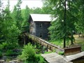 view gallery view gallery NW10.1 km NW10.1 km
|  BEAN'S MILL- OPELICKA, ALABAMA BEAN'S MILL- OPELICKA, ALABAMA
in Water Mills Located on US Highway 29 at mile marker 197 (approximately 6 miles east of Opelika, Alabama)
posted by: Sprinterman location: Alabama date approved: 07/22/2009 last visited: 07/19/2009 |
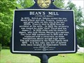 view gallery view galleryNW10.3 km | BEAN'S MILL-HCC-Lee County in Alabama Historical Markers Located on US Highway 29 at mile marker 197 (approximately 6 miles east of Opelika) posted by: Sprinterman location: Georgia date approved: 07/21/2009 last visited: 01/12/2022 |
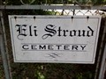 view gallery view galleryS10.9 km |  Eli Stroud Cemetery Eli Stroud Cemetery
in Bookcrossing Zones This is Eli Stroud Cemetery Where A Official Bookcrossing zone is located Registered on geocaching , bookcrossing , and now waymarking The Cords listed are to the Cache which is the official zone posted by: akk32 location: Alabama date approved: 06/29/2010 last visited: never |
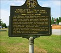 view gallery view gallery E11.3 km E11.3 km
|  Bartlett's Ferry Dam: Antioch Baptist Church-GHM 072-10-Harris Co Bartlett's Ferry Dam: Antioch Baptist Church-GHM 072-10-Harris Co
in Georgia Historical Markers Ga 219 south of the church at the road to the dam posted by: Sprinterman location: Georgia date approved: 07/21/2009 last visited: 07/08/2002 |
 view gallery view galleryNW12.2 km | Shady Grove Christian Church - Opelika, AL in Alabama Historical Markers Located on Lee Road near US 29, Opelika posted by: Markerman62 location: Alabama date approved: 04/27/2022 last visited: never |
 view gallery view gallery SE13.8 km SE13.8 km
| Mike & Ed's BBQ - Smiths Station, AL in Classic BBQ and Sandwich Joints Two started out selling insurance and figured BBQ would be more fun posted by: nomadwillie location: Alabama date approved: 02/18/2013 last visited: never |
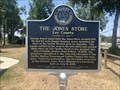 view gallery view gallerySE14 km | The Jones Store - Lee County - Smiths Station, AL in Alabama Historical Markers Located at 1224 Co Rd 298, Smiths Station posted by: Markerman62 location: Alabama date approved: 07/23/2022 last visited: never |
 view gallery view gallerySE14.5 km |  FIRST -- Graduating Class the Georgetown HS, Georgetown GA FIRST -- Graduating Class the Georgetown HS, Georgetown GA
in First of its Kind Georgetown Hugh School graduated its first class of students in 1926 posted by: Benchmark Blasterz location: Georgia date approved: 09/11/2017 last visited: 07/29/2017 |
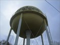 view gallery view galleryNW14.5 km |  Boots and Bridges Boots and Bridges
in Water Towers water tower posted by: Sharpslaw location: Alabama date approved: 12/15/2007 last visited: never |
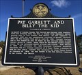 view gallery view galleryNW14.5 km | Pat Garrett and Billy the Kid - Cusseta, AL in Alabama Historical Markers Marker tells of the Alabama born Pat Garrett and his history with Billy the Kid in New Mexico. posted by: hoteltwo location: Alabama date approved: 02/09/2014 last visited: 01/11/2022 |
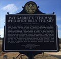 view gallery view galleryNW14.5 km | Pat Garrett, "The Man Who Shot Billy the Kid" - Cusseta, AL in Alabama Historical Markers Marker provides the early history of Pat Garrett, born in Cusseta Alabama, and move to southwest U.S. posted by: hoteltwo location: Alabama date approved: 02/09/2014 last visited: 01/11/2022 |
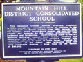 view gallery view galleryE15 km | Mountain Hill District Consolidated School in Georgia Historical Markers Mountain Hill District Consolidated School HCC 47 Mountain Hill Rd. at Ga. 219 near Hamilton posted by: The Cheyniacs location: Georgia date approved: 05/07/2008 last visited: 01/10/2022 |
 view gallery view galleryE15 km |  Mountain Hill District Consolidated School - Harris County, GA, USA Mountain Hill District Consolidated School - Harris County, GA, USA
in Former Schools Mountain Hill District Consolidated School.
47 Mountain Hill Rd. at Ga. 219 near Hamilton, GA, USA posted by: The Cheyniacs location: Georgia date approved: 05/07/2008 last visited: 01/10/2022 |
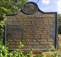 view gallery view gallerySE15.3 km | Line 32° 28´ North Latitude - Smiths Station, AL in Alabama Historical Markers After France gave area to Britain, in the Colonial Era, surveyors marked the boundaries including this one near County Road 430 in south Smiths Station. posted by: hoteltwo location: Alabama date approved: 06/27/2014 last visited: 06/29/2022 |
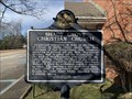
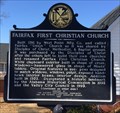 view gallery view gallery N16.1 km N16.1 km
| Fairfax First Christian Church - Valley, AL in Alabama Historical Markers Located near the old mills on Boulevard in west Valley, this historic church has many original features and is an historic landmark building. posted by: hoteltwo location: Alabama date approved: 02/09/2014 last visited: 01/11/2022 |
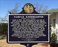 view gallery view galleryN16.1 km | Fairfax Kindergarten - Valley, AL in Alabama Historical Markers One of the Mill built kindergarten buildings located on Boulevard in west Valley is now used as a social center. posted by: hoteltwo location: Alabama date approved: 02/09/2014 last visited: 01/11/2022 |
 view gallery view galleryN16.1 km |  Valley Armed Forces Tribute - Valley, AL Valley Armed Forces Tribute - Valley, AL
in Non-Specific Veteran Memorials Located in front of the Fairfax First Baptist Church on Boulevard in Valley, AL this monument is dedicated to all veterans from all wars. posted by: hoteltwo location: Alabama date approved: 02/14/2014 last visited: 01/11/2022 |
 view gallery view gallerySW16.6 km |  Opelika Quarry Opelika Quarry
in Active Quarries A quarry located in Opelika, Alabama. posted by: driver8 location: Alabama date approved: 10/18/2005 last visited: 10/25/2021 |
|