 view gallery view gallery SW14 km SW14 km
|   Valley Creek Cemetery -- Valley Grande, AL Valley Creek Cemetery -- Valley Grande, AL
in Worldwide Cemeteries Peaceful Valley Creek Cemetery in the rural community of Valley Grande, northwest of Selma AL posted by:  Benchmark Blasterz Benchmark Blasterz location: Alabama date approved: 03/08/2019 last visited: 01/14/2019 |
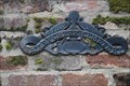
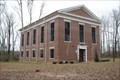 view gallery view gallerySW14.3 km |  Valley Creek Presbyterian Church -- Valley Grande AL Valley Creek Presbyterian Church -- Valley Grande AL
in Presbyterian Churches A simple unadorned church building built with slave made bricks and slave labor stands in the rural community of Valley Grande, northwest of Selma posted by: Benchmark Blasterz location: Alabama date approved: 03/06/2019 last visited: 01/14/2019 |
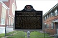
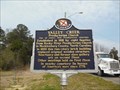 view gallery view gallerySW15 km |  Valley Creek Presbyterian Church - Selma, AL Valley Creek Presbyterian Church - Selma, AL
in Alabama Historical Markers The marker is located on Citizens Parkway (Alabama Hwy 22), at the intersection with County Road 65, north of Selma, Alabama. It tells the history of Valley Creek Presbyterian Church. posted by: xptwo location: Alabama date approved: 06/01/2013 last visited: 01/14/2019 |
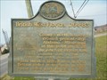 view gallery view gallerySW15.4 km | British West Florida - Selma, AL in Alabama Historical Markers This marker notes the north boundary line for the British colony of West Florida during its existence from 1764 to 1783. posted by: xptwo location: Alabama date approved: 04/15/2013 last visited: never |
 view gallery view gallerySW15.4 km |  British West Florida - Selma, Alabama British West Florida - Selma, Alabama
in UK Historical Markers This marker notes the north boundary line for the British colony of West Florida during its existence from 1764 to 1783. posted by: xptwo location: Alabama date approved: 03/11/2013 last visited: never |
 view gallery view gallery W15.8 km W15.8 km
| Childers Chapel - Valley Grande, AL in Alabama Historical Markers Historic rural cemetery along County Road 37, north of Selma, includes many older grave markers. Access is difficult as the gates have chains and locks. posted by:  hoteltwo hoteltwo location: Alabama date approved: 02/17/2015 last visited: never |
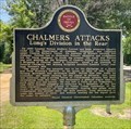 view gallery view gallerySW16.3 km | Chalmers Attacks - Valley Grande, AL in Alabama Historical Markers Located near Keenan's Mill on Lapsley Street the marker describes Union Gen. Wilson's advance into Alabama to destroy the arms depots in Selma near the end of the Civil War. posted by: hoteltwo location: Alabama date approved: 05/31/2023 last visited: never |
 view gallery view gallerySW17.2 km |  Lannie's Bar-B-Q Spot -- Selma AL Lannie's Bar-B-Q Spot -- Selma AL
in Historic Eats Lannie's Bar-B-Q Spot has been serving up outstanding BBQ since 1946 posted by: Benchmark Blasterz location: Alabama date approved: 03/06/2019 last visited: 01/14/2019 |
 view gallery view gallerySW17.2 km |  Lannie's Bar-B-Q Spot -- Selma AL Lannie's Bar-B-Q Spot -- Selma AL
in Classic BBQ and Sandwich Joints We had the best barbecue we've ever had in Alabama at this very humble neighborhood barbecue joint in an economically disadvantaged neighborhood in Selma. posted by: Benchmark Blasterz location: Alabama date approved: 03/07/2019 last visited: 01/15/2019 |
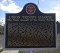 view gallery view gallerySW17.7 km | Union Troops Charge - Selma, AL in Alabama Historical Markers Notes the major actions at nearby fortifications in Selma during the Battle of Selma at the end of the Civil War. Marker is at the intersection of Summerfield Road and Highland Avenue. posted by: hoteltwo location: Alabama date approved: 04/07/2015 last visited: 04/30/2018 |
 view gallery view gallerySW17.9 km | Redoubt No. 15 - Selma. AL in Alabama Historical Markers Part of the fortifications in Selma, this marker notes the Battle of Selma at the end of the Civil War. Marker is at the intersection of Summerfield Road and Battery Avenue. posted by: hoteltwo location: Alabama date approved: 04/07/2015 last visited: never |
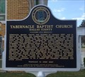 view gallery view gallerySW18 km | Tabernacle Baptist Church (Dallas County) - Selma, AL in Alabama Historical Markers One of two markers in front of this historic church, notes its beginnings and architecture.
Marker is at the intersection of Broad Street and Minter Avenue. posted by: hoteltwo location: Alabama date approved: 04/07/2015 last visited: never |
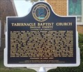 view gallery view gallerySW18 km | Tabernacle Baptist Church (Dallas County) - Selma, AL in Alabama Historical Markers Lists the pastors and leadership of the church and their impact on Civil Rights and the church. Marker is at the intersection of Broad St and Minter Ave on the left side of the church on Broad St. posted by: hoteltwo location: Alabama date approved: 04/07/2015 last visited: never |
 view gallery view gallerySW18.2 km | George Washington Carver Homes Projects -- Selma AL in Alabama Historical Markers A state historic marker for the George Washington Carver Homes Projects, a bleak post-WWII housing project development for impoverished blacks in segregated Selma AL posted by: Benchmark Blasterz location: Alabama date approved: 09/07/2017 last visited: 07/01/2023 |
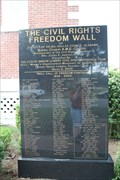 view gallery view gallerySW18.2 km |  Civil Rights Freedom Wall -- Selma AL Civil Rights Freedom Wall -- Selma AL
in Civil Rights Memorials A polished black granite memorial known as the Civil Rights Freedom Wall at the Brown Chapel AME church in Selma AL posted by: Benchmark Blasterz location: Alabama date approved: 09/01/2017 last visited: 07/01/2023 |
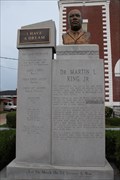 view gallery view gallerySW18.2 km | MLK Monument -- Brown Chapel AME Church, Selma AL in Civil Rights Memorials This modern grey granite memorial in front of the Brown Chapel AME Church in the George Washington Carver Homes area of Selma posted by: Benchmark Blasterz location: Alabama date approved: 09/01/2017 last visited: 07/01/2023 |
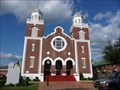 view gallery view gallerySW18.2 km |  Brown Chapel A.M.E. Church (Selma, Alabama) Brown Chapel A.M.E. Church (Selma, Alabama)
in Wikipedia Entries Brown Chapel A.M.E. Church is a church in Selma, Alabama, United States. This church was a starting point for the Selma to Montgomery marches in 1965 and played a major role in the events that led to the adoption of the Voting Rights Act of 1965. posted by: nomadwillie location: Alabama date approved: 12/18/2009 last visited: 07/01/2023 |
 view gallery view gallerySW18.2 km |  Selma to Montgomery March Byway - AL Selma to Montgomery March Byway - AL
in National Scenic Byways Starting in Selma AL at the Brown Church, walking 51 miles, ending at the State Capitol, the freedom civil rights workers marked a very important time in our history.
The coordinates are marked at the Brown Chapel AME Church in Selma AL. posted by: nomadwillie location: Alabama date approved: 07/24/2011 last visited: 07/01/2023 |
 view gallery view gallerySW18.2 km |  Brown Chapel African Methodist Episcopal Church - Selma AL Brown Chapel African Methodist Episcopal Church - Selma AL
in Dr. Martin Luther King, Jr. Brown Chapel A.M.E. Church is a church in Selma, Alabama, United States. This church was a starting point for the Selma to Montgomery marches in 1965 and played a major role in the events that led to the adoption of the Voting Rights Act of 1965. posted by: nomadwillie location: Alabama date approved: 10/27/2009 last visited: 07/01/2023 |
 view gallery view gallerySW18.2 km |  Brown Chapel African Methodist Episcopal Church - Selma AL Brown Chapel African Methodist Episcopal Church - Selma AL
in U.S. National Register of Historic Places Brown Chapel A.M.E. Church is a church in Selma, Alabama, United States. This church was a starting point for the Selma to Montgomery marches in 1965 and played a major role in the events that led to the adoption of the Voting Rights Act of 1965. posted by: nomadwillie location: Alabama date approved: 06/21/2009 last visited: 07/01/2023 |
 view gallery view gallerySW18.2 km |  Brown Chapel AME Church -- Selma AL Brown Chapel AME Church -- Selma AL
in Methodist Churches Brown Chapel African Methodist Episcopal Church is a deeply historic Wesleyan Church, a center of the Civil Rights movement in Alabama, and the starting point for the Selma-Montgomery Marches of March 1965 posted by: Benchmark Blasterz location: Alabama date approved: 09/02/2017 last visited: 07/01/2023 |
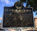 view gallery view gallerySW18.3 km | R.B. Hudson High School - Selma, AL in Alabama Historical Markers Location of first Selma High School whose students played a role in the Civil Rights Movement. Located at the intersection of Summerfield Road and 1st Avenue. posted by: hoteltwo location: Alabama date approved: 04/29/2015 last visited: never |
 view gallery view gallerySW18.3 km | Last Stronghold Falls (Alabama & Mississippi Railroad Depot) - Selma, AL in Alabama Historical Markers Describes the last chance to defend Selma by using the railroad bed as defenses. Marker is at the intersection of Broad St. (Bus U.S. 80) and Voeglin Ave just south of the train tracks, posted by: hoteltwo location: Alabama date approved: 04/29/2015 last visited: never |
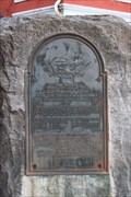 view gallery view gallerySW18.3 km |  Military Command Staff of Selma Navy Yard and the Ordinance Works -- Selma AL Military Command Staff of Selma Navy Yard and the Ordinance Works -- Selma AL
in Non-Specific Veteran Memorials This UDC marker in front of the Old Depot Museum in Selma AL preserves the memory of this site as the Selma Navy Yard and the Ordinance Works, and the names of the Navy command staff in charge of it, posted by: Benchmark Blasterz location: Alabama date approved: 09/03/2017 last visited: 07/26/2017 |
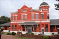 view gallery view gallerySW18.3 km |  Former Southern Railway Depot -- Selma AL Former Southern Railway Depot -- Selma AL
in Train Stations/Depots The former Southern Railway depot at Selma, now the Old Selma Museum posted by: Benchmark Blasterz location: Alabama date approved: 09/01/2017 last visited: 07/01/2023 |
|