 view gallery view gallery E7.4 km E7.4 km
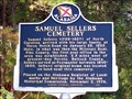
|   Samuel Sellers Cemetery - Blues Old Stand, AL Samuel Sellers Cemetery - Blues Old Stand, AL
in Alabama Historical Markers Samuel Sellers (1788-1857) came to Alabama from North Carolina in 1835. posted by:  hummerstation hummerstation location: Alabama date approved: 11/13/2012 last visited: never |
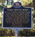 view gallery view galleryE10.5 km | Three Notch Road - Blues Old Stand, AL in Alabama Historical Markers Located at the corner of US Highway 29 and County Road 19 in the community of Blues Old Stand, this marker notes the building of a antebellum road thru Alabama. posted by:  hoteltwo hoteltwo location: Alabama date approved: 10/27/2015 last visited: 07/13/2022 |
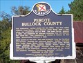 view gallery view galleryE10.9 km | Perote Bullock County - Perote, AL in Alabama Historical Markers Perote, settled during the mid-1830s, was first called Fulford’s Cross Roads, then Missouri Cross Roads when a post office was established here in 1846, was renamed Perote in 1850. posted by: hummerstation location: Alabama date approved: 11/13/2012 last visited: 07/13/2022 |
 view gallery view gallery N12.4 km N12.4 km
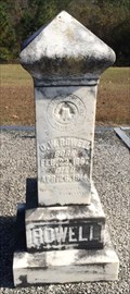
|  O. W. Rowell - Mt Hilliard Methodist Church Cemetery - Union Springs, AL O. W. Rowell - Mt Hilliard Methodist Church Cemetery - Union Springs, AL
in Woodmen of the World Grave Markers/Monuments WOW monument for Oscar W. Rowell, born February 22nd, 1867 and died April 26th, 1914. posted by: hoteltwo location: Alabama date approved: 11/18/2013 last visited: never |
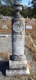 view gallery view galleryN12.4 km | John H. Faulkner - Mt Hilliard Methodist Church Cemetery - Union Springs, AL in Woodmen of the World Grave Markers/Monuments WOW monument for John H. Faulkner born December 20th, 1889 and died October 23, 1918. posted by: hoteltwo location: Alabama date approved: 11/18/2013 last visited: never |
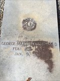 view gallery view galleryN12.4 km | George M. Guthrie, MD - Mt Hilliard Methodist Church Cemetery - Union Springs, AL in Woodmen of the World Grave Markers/Monuments Slab marker with WOW emblem for George Martin Guthrie, MD, born February 23rd, 1876 and died January 9th, 1938. posted by: hoteltwo location: Alabama date approved: 11/18/2013 last visited: never |
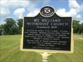 view gallery view galleryN12.6 km | Mt. Hilliard Methodist Church (1835) - Union Springs, AL in Alabama Historical Markers This marker is located in front of the Mt. Hilliard Methodist Church on Old Ridge Rd (Bullock County Highway 14) between Hook's Crossroads and High Ridge. posted by: hoteltwo location: Alabama date approved: 07/29/2013 last visited: never |
 view gallery view gallery NW14.5 km NW14.5 km
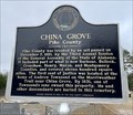
| China Grove - Pike County, AL in Alabama Historical Markers Located on Salem Rd, off Co Rd 7702, this marker describes the early settlement of China Grove, AL. China Grove was one of the first settled areas in Pike County. posted by: hoteltwo location: Alabama date approved: 01/16/2022 last visited: never |
 view gallery view gallery S15 km S15 km
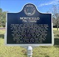
| Monticello - Banks, AL in Alabama Historical Markers Located on AL-15 next to the Monticello Baptist Church, this marker describes the former county seat of Pike County and its formation and settlers. posted by: hoteltwo location: Alabama date approved: 11/23/2020 last visited: 07/14/2022 |
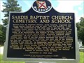 view gallery view galleryN15.8 km | Sardis Baptist Church (1850) - Union Springs, AL in Alabama Historical Markers This marker is located in front of the inactive Sardis Baptist Church on the corner of Highway 223 and County Road 22 south of Union Springs, Alabama. posted by: hoteltwo location: Alabama date approved: 07/29/2013 last visited: never |
 view gallery view gallery W17.5 km W17.5 km
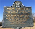
| Orion Institute - Orion, AL in Alabama Historical Markers Rural marker located at intersection of Pike County Roads 37 and 105 about the Orion settlers and early school. posted by: hoteltwo location: Alabama date approved: 03/06/2014 last visited: 07/31/2022 |
 view gallery view gallery NE17.9 km NE17.9 km
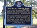
| Aberfoil Community - Aberfoil, AL in Alabama Historical Markers Aberfoil was the first town incorporated within the present boundaries of Bullock County, and was one of three sites considered for the county seat in 1867. posted by: hummerstation location: Alabama date approved: 11/11/2012 last visited: 07/13/2022 |
 view gallery view galleryNE17.9 km |  First - Town Incorporated in Bullock County - Aberfoil, AL First - Town Incorporated in Bullock County - Aberfoil, AL
in First of its Kind The town of Aberfoil was incorporated January 26, 1839, in then Macon County. When county boundaries were changed Aberfoil became the first town incorporated within the present boundaries of Bullock County. posted by: hummerstation location: Alabama date approved: 11/25/2012 last visited: never |
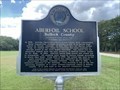 view gallery view galleryNE18.5 km | Aberfoil School - Bullock County - Aberfoil, Alabama in Alabama Historical Markers Located at on Alabama 239, 1/2 mile south of U.S. 29, Aberfoil posted by: Markerman62 location: Alabama date approved: 08/12/2022 last visited: never |
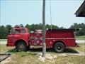 view gallery view galleryW19 km |  Meeksville VFD Fire Truck - Troy, Alabama Meeksville VFD Fire Truck - Troy, Alabama
in Fire Fighting Vehicles This fire truck is parked on the road side of the Pioneer Village Flea Market. posted by: xptwo location: Alabama date approved: 07/11/2012 last visited: never |
 view gallery view gallery SW20.4 km SW20.4 km
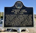
| Tuskegee Army Air Field Hangar - Troy, AL in Alabama Historical Markers Marker is located at the Troy Municipal Airport, north of the City of Troy. It describes the nearby three hangars used by the Tuskegee Airmen during their training in Tuskegee. There were relocated here for reuse. posted by: hoteltwo location: Alabama date approved: 03/16/2018 last visited: 07/31/2022 |
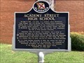 view gallery view gallerySW21.1 km | Academy Street High School - Troy, AL in Alabama Historical Markers Located at 730 E Academy St, Troy posted by: Markerman62 location: Alabama date approved: 08/12/2022 last visited: never |
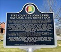 view gallery view gallerySW21.2 km | Pike County's John Lewis: National Civil Rights Icon - Troy, AL in Alabama Historical Markers Located next to the Troy Public Library, describes a part of Civil RIghts leader John Lewis life up to and including the attack on the Edmund Pettus bridge in Selma, Alabama. posted by: hoteltwo location: Alabama date approved: 03/30/2021 last visited: 07/31/2022 |
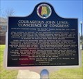 view gallery view gallerySW21.2 km | Courageous John Lewis: 'Conscience of Congress' - Troy, AL in Alabama Historical Markers Notes the rise of John Lewis from a Civil Rights leader to being elected to the U.S. House of Representatives, serving more than 30 years. posted by: hoteltwo location: Alabama date approved: 03/30/2021 last visited: 07/31/2022 |
 view gallery view gallerySW21.4 km |  Troy TrojanVision TV -- Troy University, Troy AL USA Troy TrojanVision TV -- Troy University, Troy AL USA
in Radio and Television Transmitter Towers The transmitter for the student-run TV station at Troy University posted by: Benchmark Blasterz location: Alabama date approved: 09/05/2017 last visited: 07/26/2017 |
 view gallery view gallerySW21.4 km | WTSU-FM 90.7, WRWA-FM 88.7, WTJB 91.7 -- Troy University, Troy AL USA in Radio and Television Transmitter Towers The commercial student-run radio station at Troy State University broadcasts to three cities on three frequencies from its transmitter site on campus posted by: Benchmark Blasterz location: Alabama date approved: 09/05/2017 last visited: 07/26/2017 |
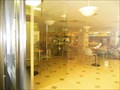 view gallery view gallerySW21.4 km |  A&W - Troy, Alabama A&W - Troy, Alabama
in A + W Restaurants This A&W is located in the Trojan Center of Troy University in Troy, Alabama. posted by: xptwo location: Alabama date approved: 07/01/2012 last visited: never |
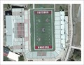 view gallery view gallerySW21.4 km |  "Trojans" - Troy University - Troy, AL "Trojans" - Troy University - Troy, AL
in Readable From Above Larry Blakeney Field at Veterans Memorial Stadium has the name of the football team, Trojans, in the end zones. posted by: xptwo location: Alabama date approved: 04/20/2013 last visited: 07/28/2017 |
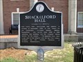 view gallery view gallerySW21.4 km | Shackelford Hall -Troy, AL in Alabama Historical Markers Located in front of Shackelford Hall at Troy University off University Avenue. posted by: Markerman62 location: Alabama date approved: 08/12/2022 last visited: never |
 view gallery view gallerySW21.6 km |  Troy University Cupola (BT2186) - Troy, Alabama Troy University Cupola (BT2186) - Troy, Alabama
in U.S. Benchmarks The cupola on Bibb Graves Hall on the Quad at Troy University is a marker. posted by: xptwo location: Alabama date approved: 10/11/2012 last visited: 07/28/2017 |
|