 view gallery view gallery NE19.8 km NE19.8 km
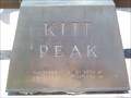
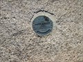
|   Kitt Peak National Observatory - 31° 57' 30.32" N 7h 26 m 22.72" W Kitt Peak National Observatory - 31° 57' 30.32" N 7h 26 m 22.72" W
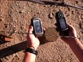
in Permanent Geographic Coordinates A block engraved on the sundial at the Kitt Peak National Observatory posted by:  TucsonThompsen TucsonThompsen location: Arizona date approved: 06/03/2010 last visited: 07/26/2021 |
 view gallery view galleryNE19.8 km |  Sun Clock at Kitt Peak National Observatory, Arizona 386, Sells, AZ 85634 Sun Clock at Kitt Peak National Observatory, Arizona 386, Sells, AZ 85634
in Sundials The polished sphere of Jacobs' sun clock. posted by: thearizonaguy location: Arizona date approved: 05/29/2015 last visited: 10/15/2015 |
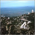 view gallery view galleryNE19.8 km |  Kitt Peak National Observatory (Tucson, Arizona) Kitt Peak National Observatory (Tucson, Arizona)
in Astronomical Observatories Kitt Peak National Observatory (KPNO), part of the National Optical Astronomy Observatory (NOAO), supports the most diverse collection of astronomical observatories on Earth for nighttime optical and infrared astronomy and daytime study of the Sun. posted by:  CPT Kelly & MAJ Sandy CPT Kelly & MAJ Sandy location: Arizona date approved: 03/27/2006 last visited: 06/20/2021 |
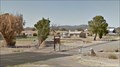
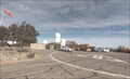 view gallery view galleryNE19.8 km |  Kitt Peak Helipad Kitt Peak Helipad
in Helicopter Landing Pads The Helipad at Kitt Peak National Observatory posted by: TucsonThompsen location: Arizona date approved: 06/04/2010 last visited: 09/08/2019 |
 view gallery view gallery S38.3 km S38.3 km
|  Nogales-Grand Avenue Port of Entry - Nogales AZ Nogales-Grand Avenue Port of Entry - Nogales AZ
in Wikipedia Entries Nogales-Grand Avenue Port of Entry is located at 9 North Grand Ave, Nogales AZ 85621 posted by: Don.Morfe location: Arizona date approved: 06/29/2024 last visited: 06/29/2024 |
 view gallery view galleryNE42.2 km |  Desert Tortoise Crossing, Pima County, AZ Desert Tortoise Crossing, Pima County, AZ
in Turtle Crossings Turtle sightings near a geocache in Southern Arizona. posted by: tugies location: Arizona date approved: 08/02/2014 last visited: 06/18/2021 |
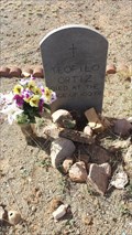 view gallery view gallery SE42.8 km SE42.8 km
|  102 - Teofilo Ortiz, - Arivaca, Arizona 102 - Teofilo Ortiz, - Arivaca, Arizona
in Headstones of Centenarians A centenarian buried in a historic cemetery and town near the Mexican border. posted by: tugies location: Arizona date approved: 02/23/2017 last visited: 02/23/2017 |
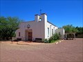
 view gallery view gallerySE43 km |  St. Ferdinand Mission Church - Arivaca, AZ St. Ferdinand Mission Church - Arivaca, AZ
in Roman Catholic Churches Gated mission church located along Arivaca Road. posted by: HiFiLZ location: Arizona date approved: 04/23/2008 last visited: 04/22/2008 |
 view gallery view galleryNE46.2 km |  Buckelew Farms - Corn Maze - Tucson, AZ Buckelew Farms - Corn Maze - Tucson, AZ
in Outdoor Mazes Buckelew Farms is a local farm that adds to the Halloween fun with it's infamous corn maze. Every year it's a newly designed shape. posted by: Poehunters location: Arizona date approved: 07/02/2013 last visited: 10/17/2015 |
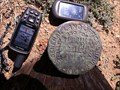
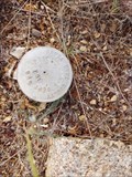
 view gallery view gallery E50.4 km E50.4 km
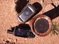
|  United States Army C.O.E. Disk E of Gunsight Mtn., Tucson, AZ United States Army C.O.E. Disk E of Gunsight Mtn., Tucson, AZ
in U.S. Benchmarks This is a bench mark type disk but has no data. posted by: sunspider location: Arizona date approved: 01/05/2014 last visited: never |
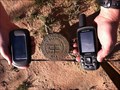
 view gallery view galleryNE50.4 km | T16SR11E in U.S. Benchmarks U.S. General Land Office Survey - 1915. T16SR11ESWCOR Benchmark SW corner of Indian Reservation.
S28-S27
S33-S34 posted by: philbeer location: Arizona date approved: 06/04/2012 last visited: 06/06/2012 |
 view gallery view gallery NW52.6 km NW52.6 km
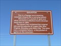
|  Quijotoa Quijotoa
in Arizona Historical Markers This is a Papago word meaning, mountain shaped like a carrying basket. posted by: leadhiker location: Arizona date approved: 05/17/2010 last visited: 03/12/2011 |
 view gallery view galleryNE54.4 km | LS4080 1/4 in U.S. Benchmarks LS4080 1/4 posted by: philbeer location: Arizona date approved: 06/04/2012 last visited: 06/06/2012 |
 view gallery view galleryNE59.2 km | T15SR11E in U.S. Benchmarks US General Land Office Survey 1915 , T15SR11E S28-S24/S25-26, P1R posted by: philbeer location: Arizona date approved: 06/04/2012 last visited: 06/06/2012 |
 view gallery view galleryNE59.9 km | E1S2415S25 in U.S. Benchmarks US General Land Office Survey - 1915 E1S2415S25 P1R posted by: philbeer location: Arizona date approved: 06/04/2012 last visited: 06/06/2012 |
 view gallery view galleryNE60.4 km | T15S R11E in U.S. Benchmarks US General Land Office Survey -1915 T15SR112 posted by: philbeer location: Arizona date approved: 06/04/2012 last visited: 06/04/2012 |
 view gallery view galleryNE60.7 km | 1S1E/16S30 P1R in U.S. Benchmarks US General Land Office Survey - 1915 1S1E/16S30 P1R posted by: philbeer location: Arizona date approved: 06/04/2012 last visited: 06/06/2012 |
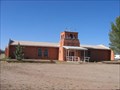
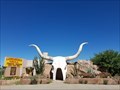 view gallery view galleryE60.7 km |  WII-28 Longhorn Grill WII-28 Longhorn Grill
in Odd-Shaped Buildings Alice doesn't live here anymore... posted by: Wayfarer II location: Arizona date approved: 11/02/2005 last visited: 09/13/2024 |
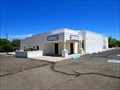 view gallery view galleryE60.7 km |  The Universal Apostolic Church of Jesus Christ - Amado, AZ The Universal Apostolic Church of Jesus Christ - Amado, AZ
in Religious Buildings Multifarious This is one of two church buildings in the small community of Amado. posted by: rjmcdonough1 location: Arizona date approved: 06/26/2019 last visited: never |
 view gallery view galleryE61 km |  Bell Tower, Assumption of Mary - Amado, AZ Bell Tower, Assumption of Mary - Amado, AZ
in Bell Towers This tower supports a hand operated bell. posted by: rjmcdonough1 location: Arizona date approved: 06/24/2019 last visited: never |
 view gallery view galleryE61 km | Assumption of Mary Catholic Church - Amado, AZ in Roman Catholic Churches This church is a mission of the Church of St. Anne in Tubac. posted by: rjmcdonough1 location: Arizona date approved: 06/21/2019 last visited: never |
 view gallery view galleryE61.2 km |  Santa Cruz County 107 - Amado, AZ Santa Cruz County 107 - Amado, AZ
in Public Land Survey Marks County marker at edge of dead end public road posted by: tnwave location: Arizona date approved: 09/09/2019 last visited: 09/09/2019 |
 view gallery view galleryNE61.3 km | 1S19/16S30 P1R in U.S. Benchmarks 1S19/16S30 P1R posted by: philbeer location: Arizona date approved: 06/04/2012 last visited: 06/06/2012 |
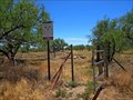 view gallery view galleryE61.5 km |  Amado Trailhead, Juan Bautista de Anza Historic Trail - Amado, AZ Amado Trailhead, Juan Bautista de Anza Historic Trail - Amado, AZ
in Hiking and walking trailheads This trailhead, on Amado Road, begins a two mile public access section of the de Anza Trail. posted by: rjmcdonough1 location: Arizona date approved: 07/03/2019 last visited: never |
 view gallery view galleryNE61.6 km | T15 R12E S19-S20/S30/S28 in U.S. Benchmarks US General Land Office Survey - 1915 , T15 R12E S19-S20/S30/S28 posted by: philbeer location: Arizona date approved: 06/04/2012 last visited: 06/06/2012 |
|