 view gallery view gallery E1 km E1 km
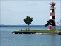
|   NOT LANDLOCKED - Lake Buchanan Lighthouse - Llano County, TX NOT LANDLOCKED - Lake Buchanan Lighthouse - Llano County, TX
in Landlocked Lighthouses Built privately by Raymond Barker in 1984. posted by:  WalksfarTX WalksfarTX location: Texas date approved: 04/25/2016 last visited: never |
 view gallery view gallery W1 km W1 km
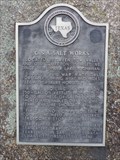
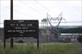
|  C.S.A. Salt Works C.S.A. Salt Works
in Texas Historical Markers Texas Historical Marker commemorating the salt works that was once nearby -- now under Lake Buchanan -- and its use by Texas and the Confederacy during the Civil War. Located in a roadside park at the intersection of TX 29 and TX 261. posted by:  QuarrellaDeVil QuarrellaDeVil location: Texas date approved: 04/28/2013 last visited: 05/17/2013 |
 view gallery view gallery NE1.8 km NE1.8 km
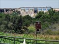
|  Lake Buchanan Dam - Burnet, Texas Lake Buchanan Dam - Burnet, Texas
in Water Dams Completed in 1937 as the first of the Highland Lakes chain (and launching the LCRA), Lake Buchanan is the largest multiple-arch dam in the U.S. and a Historic Civil Engineering Landmark of Texas. posted by: Tygress location: Texas date approved: 09/04/2013 last visited: 06/08/2019 |
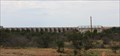 view gallery view galleryNE1.8 km |  Buchanan Dam – Burnet, TX Buchanan Dam – Burnet, TX
in Engineering Landmarks Completed by the LCRA in 1939, Buchanan Dam is the largest multi-arch dam in the world and a Historic Civil Engineering Landmark of Texas in its own right. posted by: Tygress location: Texas date approved: 09/13/2013 last visited: 06/08/2019 |
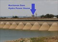 view gallery view galleryNE1.8 km |  Buchanan Dam -- Burnet Co. & Llano Co. TX Buchanan Dam -- Burnet Co. & Llano Co. TX
in Hydroelectric Power Stations The first and most beautiful of all the LCRA Highland Lakes Dams, Buchanan Dam is a 2-mile long multiple-arch hydroelectric dam in Burnet and Llano Counties of Texas posted by: Benchmark Blasterz location: Texas date approved: 10/08/2015 last visited: 05/09/2016 |
 view gallery view galleryNE1.8 km |  Buchanan Dam - Burnet, TX Buchanan Dam - Burnet, TX
in WPA Projects Located on the Colorado River, it is 143 ft from bed to parapet. It develops a reservoir of 23,500 acres. posted by: WalksfarTX location: Texas date approved: 06/15/2019 last visited: never |
 view gallery view galleryE2.4 km | Highland Lakes Chain – Lake Buchanan – Burnet, TX in Engineering Landmarks The first of what became the Highland Lakes Chain (a Historic Civil Engineering Landmark of Texas), Lake Buchanan is still the largest and boasts the largest multiple-arch dam in the U.S. posted by: Tygress location: Texas date approved: 09/17/2013 last visited: never |
 view gallery view galleryE3.1 km |  TX-29 Colorado River Bridge - Burnet County, TX TX-29 Colorado River Bridge - Burnet County, TX
in Orphaned Bridges Bridge closed to traffic. Chainlink fenced to prevent diving and fishing from it. posted by: WalksfarTX location: Texas date approved: 06/10/2019 last visited: 06/08/2019 |
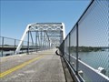
 view gallery view galleryE3.1 km |  State Highway 29 Bridge at the Colorado River - Burnet County, TX State Highway 29 Bridge at the Colorado River - Burnet County, TX
in U.S. National Register of Historic Places The bridge consists of four 200-foot Parker through truss spans and 11 I-beam approach spans. The bridge is between Buchanan Dam and Inks Lake on the Colorado River, which forms the Burnet and Llano county line. posted by: WalksfarTX location: Texas date approved: 06/13/2019 last visited: 06/08/2019 |
 view gallery view galleryE3.1 km |  TX-29 Colorado River Bridge - Burnet County, TX TX-29 Colorado River Bridge - Burnet County, TX
in Truss Bridges Bridge closed to traffic. Chainlink fenced to prevent diving and fishing from it. posted by: WalksfarTX location: Texas date approved: 06/11/2019 last visited: 06/08/2019 |
 view gallery view galleryE3.1 km |  TX-29 Colorado River Bridge - 1937 - Burnet County, TX TX-29 Colorado River Bridge - 1937 - Burnet County, TX
in Bridge Date Stones and Plaques Bridge closed to traffic. Chainlink fenced to prevent diving and fishing from it. posted by: WalksfarTX location: Texas date approved: 06/15/2019 last visited: never |
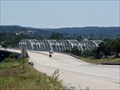 view gallery view galleryE3.2 km | State Highway 29 Bridge at the Colorado River – Burnet TX in WPA Projects The construction of the Colorado River bridge was part of a larger THD undertaking to reroute SH 29 around Buchanan Dam, which was under construction beginning in 1931. The original roadway and the bridge across the Colorado at Bluffton were inundated by Lake Buchanan after completion of the dam in 1937. posted by: WalksfarTX location: Texas date approved: 06/15/2019 last visited: never |
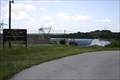 view gallery view galleryE4.5 km | Inks Dam -- Inks Lake, Llano Co. TX in Hydroelectric Power Stations The smallest hydroelectric power plant on the Lower Colorado River Authority's (LCRA) chain of six dams on the Highland Lakes. posted by: Benchmark Blasterz location: Texas date approved: 10/08/2015 last visited: 08/15/2014 |
 view gallery view galleryE4.5 km |  Inks Dam -- Llano Co. TX Inks Dam -- Llano Co. TX
in Wikipedia Entries Inks Dam is an uncontrolled hydroelectric dam built by the Lower Colorado River Authority in 1938 to create Inks Lake, now the centerpiece of a popular park posted by: Benchmark Blasterz location: Texas date approved: 01/30/2018 last visited: 08/15/2014 |
 view gallery view galleryE4.5 km | Inks Lake Dam - Llano County, Texas in Water Dams Inks Lake is the second (by months) of what became the Highland Lakes Chain, a Historic Civil Engineering Landmark of Texas, designed for water management (drought & flood) and power generation. posted by: Tygress location: Texas date approved: 09/04/2013 last visited: 08/15/2014 |
 view gallery view galleryE4.7 km | Inks Dam National Fish Hatchery - Burnet, TX in WPA Projects Work was done bhy the National Youth Administration (NYA) 1938-1941 posted by: WalksfarTX location: Texas date approved: 05/26/2020 last visited: never |
 view gallery view galleryE5.3 km | Highland Lakes Chain – Inks Lake – Llano County, TX in Engineering Landmarks The second of what became the Highland Lakes Chain (a Historic Civil Engineering Landmark of Texas)... posted by: Tygress location: Texas date approved: 09/17/2013 last visited: 08/15/2014 |
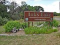 view gallery view galleryE6 km |  Inks Lake State Park - Burnet, TX Inks Lake State Park - Burnet, TX
in State/Provincial Parks Inks Lake State Park offers family fun on water and land. It is NW of Austin, TX. posted by: WalksfarTX location: Texas date approved: 05/29/2020 last visited: never |
 view gallery view gallery SE6.1 km SE6.1 km
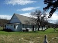
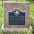
|  Hoovers Valley Cemetery - Buchanan Dam, TX Hoovers Valley Cemetery - Buchanan Dam, TX
in Worldwide Cemeteries Settlement of the area began in the early 1850s. The community was named for the Hoover family, who bought a 640-acre homestead there in 1854. posted by: WalksfarTX location: Texas date approved: 03/11/2018 last visited: 09/06/2019 |
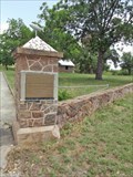
 view gallery view gallerySE6.3 km | Hoover's Valley Cemetery in Texas Historical Markers This little subject marker is affixed to a short pink granite monument next to Park Road 4 where County Road 119 ends. The cemetery it commemorates is on the opposite side of PR 4 in Burnet. posted by: QuesterMark location: Texas date approved: 08/11/2021 last visited: 11/12/2021 |
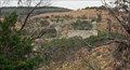
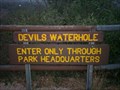 view gallery view galleryE6.8 km |  Devils Waterhole Devils Waterhole
in Geological Devilish Locations Great view of Ink's Lake State Park posted by: mcdoodles location: Texas date approved: 04/25/2006 last visited: 08/15/2014 |
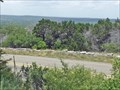 view gallery view gallerySE7.2 km |  Park Road 4 - Burnet, TX Park Road 4 - Burnet, TX
in Civilian Conservation Corps Civilian Conservation Corps Company No. 854 built this park road with overlook. posted by: WalksfarTX location: Texas date approved: 05/26/2020 last visited: never |
 view gallery view gallery S8.9 km S8.9 km
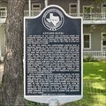
| Antlers Hotel in Texas Historical Markers This post-mounted subject marker stands in front of the hotel itself, outside the fence, to the right of the gate on King Court Road in Kingsland. posted by: QuesterMark location: Texas date approved: 06/20/2021 last visited: 03/12/2018 |
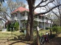 view gallery view galleryS8.9 km |  Antlers Hotel - Austin and Northwestern Railroad Historic District--Fairland to Llano - Kingsland, TX Antlers Hotel - Austin and Northwestern Railroad Historic District--Fairland to Llano - Kingsland, TX
in NRHP Historic Districts - Contributing Buildings The boundaries extend beyond the right of way in Kingsland to include the Antlers Hotel and its associated buildings and structures built by the Southern Pacific Railroad in 1901. posted by: WalksfarTX location: Texas date approved: 03/13/2018 last visited: 06/18/2021 |
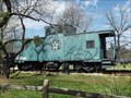 view gallery view galleryS8.9 km |  Houston & Texas Central Caboose - Kingsland, TX Houston & Texas Central Caboose - Kingsland, TX
in Train Cabooses Green caboose with Houston & Texas Central logo on the side. NW 518693 is the number on the side. posted by: WalksfarTX location: Texas date approved: 03/15/2018 last visited: never |
|