 view gallery view gallery SE0.3 km SE0.3 km
|   Burro Mesa Pouroff -- Big Bend National Park, Brewster County TX Burro Mesa Pouroff -- Big Bend National Park, Brewster County TX
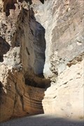
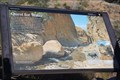
in Waterfalls The waterfall (pouroff) at Lower Burro Mesa is a dry wash that fills with flash floods, resulting in a dramatic waterfall that has carved unusual features this box canyon posted by:  Benchmark Blasterz Benchmark Blasterz location: Texas date approved: 01/28/2017 last visited: 12/24/2016 |
 view gallery view gallerySE0.3 km |  Burro Mesa Pouroff -- Big Bend National Park, Brewster County TX Burro Mesa Pouroff -- Big Bend National Park, Brewster County TX
in Places of Geologic Significance The pouroff (dry waterfall) at Lower Burro Mesa is in a dry wash that fills with flash floods, resulting in a dramatic waterfall that has carved unusual features this box canyon posted by: Benchmark Blasterz location: Texas date approved: 01/27/2017 last visited: 10/03/2023 |
 view gallery view gallery SW0.5 km SW0.5 km
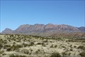
|  Burro Mesa -- Big Bend NP TX Burro Mesa -- Big Bend NP TX
in American Guide Series Burro Mesa, but not its famous waterfall, is the subject of brief remark in the 1940 WPA Guide to Texas posted by: Benchmark Blasterz location: Texas date approved: 02/09/2017 last visited: 12/27/2016 |
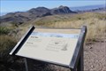
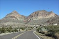
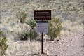
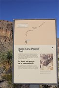 view gallery view gallerySW0.5 km |  Lower Burro Mesa Trailhead -- Ross Maxwell Scenic Drive, Big Bend NP, TX Lower Burro Mesa Trailhead -- Ross Maxwell Scenic Drive, Big Bend NP, TX
in Hiking and walking trailheads The trailhead for the Lower Burro Mesa Pouroff Trail is along the Ross Maxwell Scenic Drive posted by: Benchmark Blasterz location: Texas date approved: 02/03/2017 last visited: 12/26/2016 |
 view gallery view gallerySE3.5 km |  Sotol Vista -- Big Bend NP TX Sotol Vista -- Big Bend NP TX
in Flora and Fauna Information Signs A flora and fauna information sign about the incredibly useful Sotol plant at the Sotol Vista overlook in Big Bend National Park posted by: Benchmark Blasterz location: Texas date approved: 01/28/2017 last visited: 03/15/2017 |
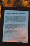 view gallery view gallerySE3.5 km | Natural Role of Fire -- Sotol Vista, Big Bend NP TX in Flora and Fauna Information Signs A small sign at the Sotol Vista teaches about the natural role of fore in a desert environment posted by: Benchmark Blasterz location: Texas date approved: 01/30/2017 last visited: 12/25/2016 |
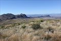 view gallery view gallerySE3.7 km |  Sotol Vista -- Big Bend NP TX Sotol Vista -- Big Bend NP TX
in Scenic Roadside Look-Outs The overlook at Sotol Vista off the Ross Maxwell Scenic Drive is a great place to watch the sunset posted by: Benchmark Blasterz location: Texas date approved: 01/28/2017 last visited: 12/24/2016 |
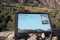
 view gallery view gallerySE4.2 km | Goat Mountain -- Big Bend NP TX in Places of Geologic Significance Much of Big Bend National Park was formed by the action of volcanoes, long since dormant. One of those old volcanoes created Goat Mountain posted by: Benchmark Blasterz location: Texas date approved: 01/28/2017 last visited: 10/03/2023 |
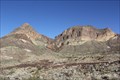 view gallery view gallerySE4.2 km |  Goat Mountain - Ross Maxell Scenic Drive, Big Bend NP, TX Goat Mountain - Ross Maxell Scenic Drive, Big Bend NP, TX
in Volcano Watching Much of Big Bend National Park was formed by the action of volcanoes, long since dormant. One of those old volcanoes created Goat Mountain posted by: Benchmark Blasterz location: Texas date approved: 01/28/2017 last visited: 03/15/2017 |
 view gallery view gallery NE4.8 km NE4.8 km
| Volcanic Dikes - Big Bend NP, TX, US in Places of Geologic Significance Located in Big Bend National park along Ross Maxwell Scenic Drive. posted by: Crazy4horses location: Texas date approved: 01/09/2017 last visited: 03/15/2017 |
 view gallery view gallery N7.2 km N7.2 km
| Chisos Mountains -- Big Bend National Park TX in Places of Geologic Significance A sign along the Ross Maxwell Scenic Drive explains the volcanic origins of the Chisos Mountains posted by: Benchmark Blasterz location: Texas date approved: 01/28/2017 last visited: 12/24/2016 |
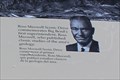 view gallery view galleryN7.2 km |  FIRST -- Superintendent of Big Bend National Park, Big Bend NP TX FIRST -- Superintendent of Big Bend National Park, Big Bend NP TX
in First of its Kind Ross Maxwell was the first Superintendent of Big Bend National Park in Texas posted by: Benchmark Blasterz location: Texas date approved: 01/30/2017 last visited: 12/25/2016 |
 view gallery view gallery S8.4 km S8.4 km
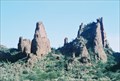
| Mule Ears Peaks - Big Bend NP TX in American Guide Series The Mule Ears Peaks, an ancient navigation landmark in the Big Bend area, earned a mention in the 1940 WPA Guide to Texas posted by: Benchmark Blasterz location: Texas date approved: 02/09/2017 last visited: 03/27/2018 |
 view gallery view galleryS8.4 km | Mule Ears Trail -- Big Bend NP TX in Hiking and walking trailheads The famous Mule Ears Peaks Trail at Big Bend, which goes out the the Mule Ears Peaks, so named because . . . well, duh posted by: Benchmark Blasterz location: Texas date approved: 02/03/2017 last visited: 12/26/2016 |
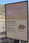 view gallery view galleryS8.4 km | Mule Ears Peaks - Big Bend NP TX in Places of Geologic Significance The famous Mule Ears Peaks at Big Bend, so named because . . . well, duh posted by: Benchmark Blasterz location: Texas date approved: 01/28/2017 last visited: 12/24/2016 |
 view gallery view galleryS8.4 km |  Mule Ears Peaks -- Big Bend NP TX Mule Ears Peaks -- Big Bend NP TX
in Simulacra The famous Mule Ears Peaks at Big Bend, so named because . . . well, you know posted by: Benchmark Blasterz location: Texas date approved: 01/28/2017 last visited: 03/27/2018 |
 view gallery view gallery E10.5 km E10.5 km
| Volcanic Origins -- Window Trail, Big Bend NP TX in Places of Geologic Significance The Chisos Mountains were formed by volcanic activity from 17-38 million years ago posted by: Benchmark Blasterz location: Texas date approved: 01/30/2017 last visited: 12/25/2016 |
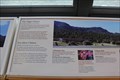
 view gallery view galleryE10.5 km |  SOUTHERNMOST -- Stand of Quaking Aspens in the US, Window Trail, Big Bend NP TX SOUTHERNMOST -- Stand of Quaking Aspens in the US, Window Trail, Big Bend NP TX
in Superlatives A Chisos Mountains information sign along the Window Trail near the Chisos Basin Visitor Center points out that the Quaking Aspen trees on Emory Peak are the southernmost stand of such trees in the US posted by: Benchmark Blasterz location: Texas date approved: 01/30/2017 last visited: 12/25/2016 |
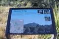
 view gallery view galleryE10.5 km | Mountain Refuge -- Big Bend NP TX in Flora and Fauna Information Signs Second of three flora and fauna information signs along the Window Trail near the Chisos Basin Visitor Center posted by: Benchmark Blasterz location: Texas date approved: 01/29/2017 last visited: 12/25/2016 |
 view gallery view galleryE10.5 km | Quest for Water -- Big Bend NP TX in Flora and Fauna Information Signs Third of three flora and fauna information signs along the Window Trail near the Chisos Basin Visitor Center posted by: Benchmark Blasterz location: Texas date approved: 01/29/2017 last visited: 12/25/2016 |
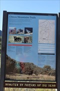 view gallery view galleryE10.6 km | Chisos Mountain Trails -- Window Trail, Big Bend NP TX in Flora and Fauna Information Signs One of three flora and fauna information signs along the Window Trail near the Chisos Basin Visitor Center posted by: Benchmark Blasterz location: Texas date approved: 01/29/2017 last visited: 12/25/2016 |
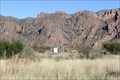 view gallery view galleryE10.6 km |  Chisos Basin Weather Station -- Big Bend NP TX Chisos Basin Weather Station -- Big Bend NP TX
in Weather Stations The Chisos Basin weather station is located behind the Chisos Basin Visitor Center at Big Bend National Park posted by: Benchmark Blasterz location: Texas date approved: 02/13/2017 last visited: 03/15/2017 |
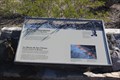
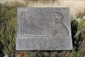 view gallery view galleryE10.6 km |  Stephen Tyng Mather -- Big Bend National Park TX Stephen Tyng Mather -- Big Bend National Park TX
in Citizen Memorials The handsome bronze memorial plaque in honor of Stephen Tyng Mather at the start of the Window Loop Trail near the Chisos Basin Visitor Center posted by: Benchmark Blasterz location: Texas date approved: 01/29/2017 last visited: 12/25/2016 |
 view gallery view galleryE10.6 km | The High Chisos -- Chisos Basin Visitor Center, Big Bend NP TX in Flora and Fauna Information Signs This sign at the Chisos Basin Visitor Center gives information about local wildlife and landforms posted by: Benchmark Blasterz location: Texas date approved: 01/28/2017 last visited: 12/24/2016 |
 view gallery view galleryE10.6 km | SOUTHERNMOST -- Mountain Range in the US, Chisos Basin Visitor Center, Big Bend NP in Superlatives The Chisos Mountains are the southernmost mountain range in the US posted by: Benchmark Blasterz location: Texas date approved: 01/28/2017 last visited: 12/24/2016 |
|