 view gallery view gallery N84.3 km N84.3 km
|   Sayil - Mexico Sayil - Mexico
in Wikipedia Entries Sayil is a Maya archaeological site in the Mexican state of Yucatán, in the southwest of the state, south of Uxmal. It was incorporated together with Uxmal as a UNESCO World Heritage Site in 1996. posted by:  Alfouine Alfouine location: Yucatán, Mexico date approved: 05/02/2024 last visited: never |
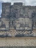 view gallery view galleryN91.7 km |  Guerilleros - Kabah - Mexico Guerilleros - Kabah - Mexico
in Figurative Public Sculpture Two restored figures (male figures used as supporting columns). These are especially interesting, as they’re some of the very few 3D human figures you’ll see at the main Maya sites. One is headless and the other wears a jaguar mask atop his head. posted by: Alfouine location: Yucatán, Mexico date approved: 05/01/2024 last visited: never |
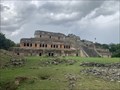
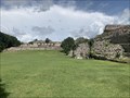
 view gallery view galleryN91.7 km |  Kabah (sitio arqueológico) - Mexico Kabah (sitio arqueológico) - Mexico
in Preserved Architectural Remnants and Ruins Kabáh es un yacimiento arqueológico maya, ubicado en el municipio de Santa Elena, en el estado de Yucatán, México, al sureste de Uxmal que forma parte de la denominada ruta Puuc. posted by: Alfouine location: Yucatán, Mexico date approved: 04/26/2024 last visited: never |
 view gallery view galleryN91.7 km |  Kabah (sitio arqueológico) - Mexico Kabah (sitio arqueológico) - Mexico
in New World Ancient Evidence Kabáh es un yacimiento arqueológico maya, ubicado en el municipio de Santa Elena, en el estado de Yucatán, México, al sureste de Uxmal que forma parte de la denominada ruta Puuc. posted by: Alfouine location: Yucatán, Mexico date approved: 04/25/2024 last visited: never |
 view gallery view galleryN91.7 km |  Kabah (sitio arqueológico) - Mexico Kabah (sitio arqueológico) - Mexico
in Official Local Tourism Attractions Kabáh es un yacimiento arqueológico maya, ubicado en el municipio de Santa Elena, en el estado de Yucatán, México, al sureste de Uxmal que forma parte de la denominada ruta Puuc. posted by: Alfouine location: Yucatán, Mexico date approved: 04/25/2024 last visited: never |
 view gallery view galleryN91.7 km | Kabah (sitio arqueológico) - Mexico in Wikipedia Entries Kabáh es un yacimiento arqueológico maya, ubicado en el municipio de Santa Elena, en el estado de Yucatán, México, al sureste de Uxmal que forma parte de la denominada ruta Puuc. posted by: Alfouine location: Yucatán, Mexico date approved: 04/25/2024 last visited: never |
 view gallery view galleryN91.7 km |  Kabah (sitio arqueológico) - Mexico Kabah (sitio arqueológico) - Mexico
in Ghost Towns Kabáh es un yacimiento arqueológico maya, ubicado en el municipio de Santa Elena, en el estado de Yucatán, México, al sureste de Uxmal que forma parte de la denominada ruta Puuc. posted by: Alfouine location: Yucatán, Mexico date approved: 04/26/2024 last visited: never |
 view gallery view galleryN91.9 km |  Kabah (sitio arqueológico) - Mexico Kabah (sitio arqueológico) - Mexico
in Signs of History Kabáh es un yacimiento arqueológico maya, ubicado en el municipio de Santa Elena, en el estado de Yucatán, México, al sureste de Uxmal que forma parte de la denominada ruta Puuc. posted by: Alfouine location: Yucatán, Mexico date approved: 04/26/2024 last visited: never |
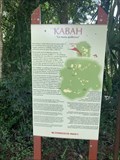 view gallery view galleryN91.9 km | KABAH La mano Poderosa - Mexico in Signs of History Kabáh es un yacimiento arqueológico maya, ubicado en el municipio de Santa Elena, en el estado de Yucatán, México, al sureste de Uxmal que forma parte de la denominada ruta Puuc. posted by: Alfouine location: Yucatán, Mexico date approved: 04/27/2024 last visited: never |
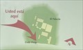 view gallery view galleryN91.9 km |  Usted Esta Aqui - Kabah - Mexico Usted Esta Aqui - Kabah - Mexico
in 'You Are Here' Maps Kabáh es un yacimiento arqueológico maya, ubicado en el municipio de Santa Elena, en el estado de Yucatán, México, al sureste de Uxmal que forma parte de la denominada ruta Puuc. posted by: Alfouine location: Yucatán, Mexico date approved: 04/28/2024 last visited: never |
 view gallery view galleryN92.1 km |  El arco - Kabah - Mexico El arco - Kabah - Mexico
in Freestanding Arches The Arch is an impressive archway marking the symbolic beginning of the 20km sacbé (causeway) to Uxmal. It was likely built between 670 and 770 CE. They say it is the largest freestanding Mayan arch! posted by: Alfouine location: Yucatán, Mexico date approved: 04/30/2024 last visited: never |
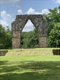 view gallery view galleryN92.1 km |  LARGEST - Freestanding Mayan arch - Kabah - Mexico LARGEST - Freestanding Mayan arch - Kabah - Mexico
in Superlatives The Arch is an impressive archway marking the symbolic beginning of the 20km sacbé (causeway) to Uxmal. It was likely built between 670 and 770 CE. They say it is the largest freestanding Mayan arch! posted by: Alfouine location: Yucatán, Mexico date approved: 05/01/2024 last visited: never |
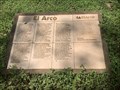 view gallery view galleryN92.1 km | El arco - Kabah - Mexico in Signs of History The Arch is an impressive archway marking the symbolic beginning of the 20km sacbé (causeway) to Uxmal. It was likely built between 670 and 770 CE. They say it is the largest freestanding Mayan arch! posted by: Alfouine location: Yucatán, Mexico date approved: 05/01/2024 last visited: never |
 view gallery view galleryN100.4 km | La iglesia de San Mateo - Santa Elena - Mexico in Signs of History La iglesia de San Mateo, en el municipio de Santa Elena, es una visita obligada para los viajeros. Desde la carretera que conduce a la Ruta Puuc se puede apreciar la fachada de la iglesia de San Mateo, en el municipio de Santa Elena. posted by: Alfouine location: Yucatán, Mexico date approved: 04/25/2024 last visited: never |
 view gallery view galleryN100.4 km |  La iglesia de San Mateo - Santa Elena - Mexico La iglesia de San Mateo - Santa Elena - Mexico
in Roman Catholic Churches La iglesia de San Mateo, en el municipio de Santa Elena, es una visita obligada para los viajeros. Desde la carretera que conduce a la Ruta Puuc se puede apreciar la fachada de la iglesia de San Mateo, en el municipio de Santa Elena. posted by: Alfouine location: Yucatán, Mexico date approved: 04/24/2024 last visited: never |
 view gallery view galleryN100.4 km | La iglesia de San Mateo - Santa Elena - Mexico in This Old Church La iglesia de San Mateo, en el municipio de Santa Elena, es una visita obligada para los viajeros. Desde la carretera que conduce a la Ruta Puuc se puede apreciar la fachada de la iglesia de San Mateo, en el municipio de Santa Elena. posted by: Alfouine location: Yucatán, Mexico date approved: 04/24/2024 last visited: never |
 view gallery view gallery S105.4 km S105.4 km
|  Tapir - Campeche - Mexico Tapir - Campeche - Mexico
in Uncommon Crossing Signs En la carretera que va de Campeche a Chetumal, cerca de la zona arqueológica de Calakmul, en la reserva de la biosfera de Calakul, hay muchas señales que indican la fauna. Este cartel representa un tapir, nos hubiera encantado ver uno. posted by: Alfouine location: Campeche, Mexico date approved: 10/07/2022 last visited: never |
 view gallery view galleryN106.9 km | The Throne of the Jaguar - Uxmal - Mexico in Figurative Public Sculpture En la plateforma se encuentra una escultura que representa a dos jaguares unidos por el tórax. Esta escultura podría haber sido un altar ceremonial. Está orientada de norte a sur. Entre esta terraza y la fachada del palacio hay una columna fálica. posted by: Alfouine location: Yucatán, Mexico date approved: 04/21/2024 last visited: never |
 view gallery view galleryN106.9 km | The Throne of the Jaguar - Uxmal - Mexico in Signs of History En la plateforma se encuentra una escultura que representa a dos jaguares unidos por el tórax. Esta escultura podría haber sido un altar ceremonial. Está orientada de norte a sur. Entre esta terraza y la fachada del palacio hay una columna fálica. posted by: Alfouine location: Yucatán, Mexico date approved: 04/21/2024 last visited: never |
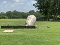 view gallery view galleryN106.9 km |  The Pillory Shrine - Uxmal - Mexico The Pillory Shrine - Uxmal - Mexico
in Punishment and Disciplinary Devices The Pillory Shrine (Adoritorio de la Picota), or Picote, a truncated cone-shaped monolith sitting on a square base, appears to have been stuccoed upon which hieroglyphics and symbolic ornamentation were painted. posted by: Alfouine location: Yucatán, Mexico date approved: 04/21/2024 last visited: never |
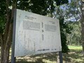 view gallery view galleryN106.9 km | The Pillory Shrine - Uxmal - Mexico in Signs of History The marker is east of the Governor's Palace at Uxmal Archaeological Site, near the Pillory Shrine, some ten kilometers from Muna, south of Mérida. posted by: Alfouine location: Yucatán, Mexico date approved: 04/21/2024 last visited: never |
 view gallery view galleryN106.9 km | The Governor's Palace - Uxmal - Mexico in Signs of History Sobre una plataforma que conforman tres terrazas que están rodeadas de una planicie se alza este edificio que es, el más destacado de la ciudad y de la arquitectura maya y está considerado como una de las cumbres arquitectónicas del México Antiguo. posted by: Alfouine location: Yucatán, Mexico date approved: 04/21/2024 last visited: never |
 view gallery view galleryN107 km | Gran Pirámide - Uxmal - Mexico in Signs of History Southwest of the House of the Governor is the Great Pyramid, a massive mound with an ornamented temple at its summit and fronting a sunken courtyard. posted by: Alfouine location: Yucatán, Mexico date approved: 04/21/2024 last visited: never |
 view gallery view galleryN107 km |  Gran Pirámide - Uxmal - Mexico Gran Pirámide - Uxmal - Mexico
in Outdoor Stairways Southwest of the House of the Governor is the Great Pyramid, a massive mound with an ornamented temple at its summit and fronting a sunken courtyard. posted by: Alfouine location: Yucatán, Mexico date approved: 04/20/2024 last visited: never |
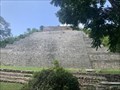 view gallery view galleryN107 km |  Gran Pirámide - Uxmal - Mexico Gran Pirámide - Uxmal - Mexico
in Pyramids Southwest of the House of the Governor is the Great Pyramid, a massive mound with an ornamented temple at its summit and fronting a sunken courtyard. posted by: Alfouine location: Yucatán, Mexico date approved: 04/20/2024 last visited: never |
|