 view gallery view gallery NE28.8 km NE28.8 km
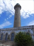
|   Phare de l'ilet de Petite-Terre Phare de l'ilet de Petite-Terre
in Coastal Lighthouses Phare de l'ilet de Petite-Terre posted by:  Papichon Papichon location: Guadeloupe date approved: 03/17/2013 last visited: never |
 view gallery view gallery N34.9 km N34.9 km
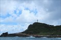
|  Pointe des Châteaux - Saint-François, Guadeloupe Pointe des Châteaux - Saint-François, Guadeloupe
in Wikipedia Entries [EN] The Pointe des Châteaux is a peninsula located at the eastern end of the island of Grande-Terre at 11 km from Saint-François, to which it is attached.
[FR] La pointe des Châteaux est une péninsule située à l’extrémité Est de l'île de Grande-Terre à 11 km de Saint-François, commune à laquelle elle est rattachée. posted by: pmaupin location: Guadeloupe date approved: 12/03/2019 last visited: 11/16/2019 |
 view gallery view galleryN34.9 km |  Pointe des Châteaux - Saint-François, Guadeloupe Pointe des Châteaux - Saint-François, Guadeloupe
in Satellite Imagery Oddities [EN] The Pointe des Châteaux is a peninsula located at the eastern end of the island of Grande-Terre, 11 km from Saint-François
[FR] La pointe des Châteaux est une péninsule située à l’extrémité Est de l'île de Grande-Terre à 11 km de Saint-François posted by: pmaupin location: Guadeloupe date approved: 01/22/2023 last visited: 01/21/2023 |
 view gallery view galleryN34.9 km |  Pointe des Châteaux - Saint-François, Guadeloupe Pointe des Châteaux - Saint-François, Guadeloupe
in Official Local Tourism Attractions [EN] The Pointe des Châteaux is a peninsula located at the eastern end of the island of Grande-Terre at 11 km from Saint-François, to which it is attached. [FR] La pointe des Châteaux est une péninsule située à l’extrémité Est de l'île de Grande-Terre à 11 km de Saint-François, commune à laquelle elle est rattachée. posted by: pmaupin location: Guadeloupe date approved: 12/03/2019 last visited: 11/16/2019 |
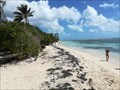
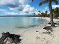
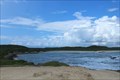 view gallery view galleryN35.4 km |  Plage des Grandes Salines - Saint François, Guadeloupe Plage des Grandes Salines - Saint François, Guadeloupe
in Beaches [EN] This beach is the last before the Pointe des Châteaux and by extension, the end of Grande Terre.
[FR] Cette plage est la dernière avant la Pointe des Châteaux et par extension, le bout de la Grande Terre. posted by: pmaupin location: Guadeloupe date approved: 01/30/2023 last visited: 01/29/2023 |
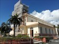
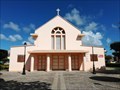 view gallery view galleryN35.9 km |  L'église Saint-François-d'Assise - Saint-François, Guadeloupe L'église Saint-François-d'Assise - Saint-François, Guadeloupe
in Roman Catholic Churches [EN] The Church of St. Francis of Assisi, rebuilt in 1932, benefited for the sacristy and the tower of the skills of Ali Tur, architect delegated by the government after the cyclone of 1928.
[FR] L’église Saint-François d’Assise, reconstruite en 1932, a bénéficié pour la sacristie et le clocher des compétences d’Ali Tur, architecte délégué par le gouvernement après le cyclone de 1928. posted by: pmaupin location: Guadeloupe date approved: 11/29/2019 last visited: 11/15/2019 |
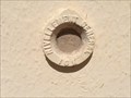
 view gallery view galleryN35.9 km |  Benchmark - Eglise Saint-François-d'Assise - Saint-François, Guadeloupe Benchmark - Eglise Saint-François-d'Assise - Saint-François, Guadeloupe
in French Benchmarks Le Repère Cylindrique du Nivellement Général se situe sur le mur de façade ouest de l'église, face à la route. posted by: pmaupin location: Guadeloupe date approved: 12/16/2019 last visited: 11/15/2019 |
 view gallery view galleryN35.9 km | Benchmark - Repère géodésique - Eglise Saint-François-d'Assise - Saint-François, Guadeloupe in French Benchmarks Repère géodésique du point a, au centre de la croix du clocher de l'église avec un Azimut de la prise de vue égal à 50 gr. posted by: pmaupin location: Guadeloupe date approved: 12/16/2019 last visited: 11/15/2019 |
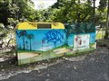 view gallery view galleryN36 km |  DO -- Avenue de l'Europe -- Saint-François, Guadeloupe DO -- Avenue de l'Europe -- Saint-François, Guadeloupe
in Places for Recycling [EN] Recycling point for paper, cardboard, aluminium, plastic and glass.
[FR] Point de recyclage pour papier, le carton, l'aluminium, le plastique et le verre. posted by: pmaupin location: Guadeloupe date approved: 02/01/2023 last visited: 02/01/2023 |
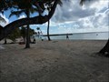
 view gallery view galleryN36.4 km |  Sentier Littoral, Anse du Belley - Pointe du Helleux Sentier Littoral, Anse du Belley - Pointe du Helleux
in 'You Are Here' Maps Sentier Littoral, Anse du Belley - Pointe du Helleux posted by: Papichon location: Guadeloupe date approved: 03/18/2013 last visited: never |
 view gallery view gallery NW36.5 km NW36.5 km
|  Coast of Saint-Anne - Grande-Terre, Guadeloupe Coast of Saint-Anne - Grande-Terre, Guadeloupe
in Web Cameras Web Cam with a Pacific Ocean view from Guadeloupe. posted by: bobfrapples8 location: Guadeloupe date approved: 01/21/2024 last visited: never |
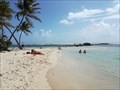
 view gallery view galleryNW36.7 km | Plage de Bois-Jolan - Sainte-Anne, Guadeloupe in Wikipedia Entries [EN] The beach of Bois-Jolan is a sandy beach of nearly 1 kilometer located east of Sainte-Anne.
[FR] La plage de Bois-Jolan est une plage de sable fin de près de 1 kilomètre située à l'est Sainte-Anne. posted by: pmaupin location: Guadeloupe date approved: 11/28/2019 last visited: 11/12/2019 |
 view gallery view galleryNW36.7 km | Plage de Bois-Jolan - Sainte-Anne, Guadeloupe in Beaches [EN] The beach of Bois-Jolan is a sandy beach of nearly 1 kilometer located east of Sainte-Anne. [FR] La plage de Bois-Jolan est une plage de sable fin de près de 1 kilomètre située à l'est Sainte-Anne. posted by: pmaupin location: Guadeloupe date approved: 11/28/2019 last visited: 11/12/2019 |
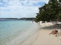
 view gallery view galleryNW36.9 km | Plage de Sainte-Anne - Saint-Anne, Guadeloupe in Beaches [EN] The beach of Sainte-Anne is also known as the beach of Bourg. [FR] La plage de Sainte-Anne est également connue sous le nom de la plage du Bourg. posted by: pmaupin location: Guadeloupe date approved: 11/28/2019 last visited: 11/15/2019 |
 view gallery view galleryNW36.9 km | Plage de la Caravelle - Sainte-Anne, Guadeloupe in Beaches [EN] The beach of La Caravelle is located at the entrance of Sainte Anne coming from Le Gosier.
[FR] La plage de La Caravelle est située à l’entrée de Sainte Anne en venant du Gosier. posted by: pmaupin location: Guadeloupe date approved: 11/20/2019 last visited: 11/06/2019 |
 view gallery view galleryNW36.9 km | Plage de la Caravelle - Sainte-Anne, Guadeloupe in Wikipedia Entries [EN] The beach of La Caravelle is located at the entrance of Sainte Anne coming from Le Gosier. [FR] La plage de La Caravelle est située à l’entrée de Sainte Anne en venant du Gosier. posted by: pmaupin location: Guadeloupe date approved: 11/06/2019 last visited: 11/06/2019 |
 view gallery view galleryNW36.9 km | Plage de Sainte-Anne - Saint-Anne, Guadeloupe in Wikipedia Entries [EN] The beach of Sainte-Anne is also known as the beach of Bourg.
[FR] La plage de Sainte-Anne est également connue sous le nom de la plage du Bourg. posted by: pmaupin location: Guadeloupe date approved: 11/28/2019 last visited: 11/15/2019 |
 view gallery view galleryNW37.2 km | Benchmark - Église Sainte-Anne - Sainte-Anne, Guadeloupe in French Benchmarks Le Repère Cylindrique du Nivellement Général se situe sur le mur de façade antérieur sud de la nef, face à la place. posted by: pmaupin location: Guadeloupe date approved: 12/16/2019 last visited: 11/12/2019 |
 view gallery view galleryNW37.2 km | Église Sainte-Anne - Sainte-Anne, Guadeloupe in Roman Catholic Churches [EN] Rebuilt in reinforced concrete between 1930 and 1935 after the terrible cyclone of 1928, the Sainte-Anne church is the work of Ali Tur, architect of the colonies.
[FR] Reconstruite en béton armé entre 1930 et 1935 après le terrible cyclone de 1928, l'église Sainte-Anne est l’œuvre d’Ali Tur, architecte des colonies. posted by: pmaupin location: Guadeloupe date approved: 12/05/2019 last visited: 11/12/2019 |
 view gallery view galleryNW37.2 km |  Église Sainte-Anne - Sainte-Anne, Guadeloupe Église Sainte-Anne - Sainte-Anne, Guadeloupe
in Art Deco - Art Nouveau [EN] Rebuilt in reinforced concrete between 1930 and 1935 after the terrible cyclone of 1928, the Sainte-Anne church is the work of Ali Tur, architect of the colonies. [FR] Reconstruite en béton armé entre 1930 et 1935 après le terrible cyclone de 1928, l'église Sainte-Anne est l’œuvre d’Ali Tur, architecte des colonies. posted by: pmaupin location: Guadeloupe date approved: 01/22/2021 last visited: 11/12/2019 |
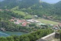 view gallery view gallery W39.1 km W39.1 km
| Stade de Marigot - Terre-de-Haut, Guadeloupe in Satellite Imagery Oddities [EN] The Stade de Marigot is the municipal stadium of Terre de Haut in the island of Saintes.
[FR] Le Stade de Marigot est le Stade municipal de Terre de Haut dans l'ile des Saintes. posted by: pmaupin location: Guadeloupe date approved: 01/29/2023 last visited: 01/29/2023 |
 view gallery view galleryW39.4 km | Allée Dumanoir - Capesterre-Belle-Eau, Guadeloupe in Official Local Tourism Attractions [EN] Dumanoir Alley is a scenic 1,200m long alley lined with over 400 royal palm trees. [FR] L'allée Dumanoir est une allée pittoresque d'une longueur de 1 200 m bordée de plus de 400 palmiers royaux. posted by: pmaupin location: Guadeloupe date approved: 01/18/2023 last visited: 01/18/2023 |
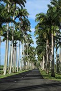 view gallery view galleryW39.4 km | Allée Dumanoir - Capesterre-Belle-Eau, Guadeloupe in Wikipedia Entries [EN] Dumanoir Alley is a scenic 1,200m long alley lined with over 400 royal palm trees.
[FR] L'allée Dumanoir est une allée pittoresque d'une longueur de 1 200 m bordée de plus de 400 palmiers royaux. posted by: pmaupin location: Guadeloupe date approved: 01/18/2023 last visited: 01/18/2023 |
 view gallery view galleryW39.6 km |  Histoire De La Guadeloupe by Auguste Lacour - Les Saintes, Guadeloupe Histoire De La Guadeloupe by Auguste Lacour - Les Saintes, Guadeloupe
in There's a Book About It Guadeloupe is an archipelago and overseas department and region of France in the Caribbean. The capital city is Basse-Terre, the most populous city is Les Abymes and the main centre of business is Pointe-à-Pitre. posted by:  denben denben location: Guadeloupe date approved: 11/17/2023 last visited: never |
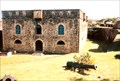 view gallery view galleryW39.6 km |  Fort Napoléon - Terre-de-Haut, Les Saintes, Guadeloupe Fort Napoléon - Terre-de-Haut, Les Saintes, Guadeloupe
in Monuments Historiques Français Fort Napoléon is located on Terre-de-Haut Island, in the Îles des Saintes, Guadeloupe. It was classified as a National Heritage Site of France in 1997. posted by: denben location: Guadeloupe date approved: 12/26/2012 last visited: never |
|