 view gallery view gallery E10.8 km E10.8 km
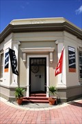
|   Bank of New Zealand — Palmerston, New Zealand Bank of New Zealand — Palmerston, New Zealand
in Converted Bank Buildings The Bank of New Zealand has been converted into a designer fashion clothing shop. posted by:  Dunbar Loop Dunbar Loop location: South Island, New Zealand date approved: 03/09/2010 last visited: 11/22/2012 |
 view gallery view galleryE10.8 km |  Centennial Clock — Palmerston, New Zealand Centennial Clock — Palmerston, New Zealand
in Town Clocks Erected in 1982 to commemorate the 100th anniversary of Waihemo County, this clock is at the main junction of state highways 1 & 85. posted by: Dunbar Loop location: South Island, New Zealand date approved: 11/22/2009 last visited: never |
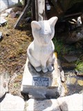 view gallery view galleryE10.8 km |  Chippie the Town Cat — Palmerston, New Zealand Chippie the Town Cat — Palmerston, New Zealand
in Animal Memorials Chippie was Palmerston's town cat from 1985 until 2000. posted by: Dunbar Loop location: South Island, New Zealand date approved: 11/24/2009 last visited: never |
 view gallery view galleryE10.9 km |  "Puketapu Radio Caroline AM 756" — Palmerston, New Zealand "Puketapu Radio Caroline AM 756" — Palmerston, New Zealand
in A.M./F.M. Radio Broadcasting Stations Puketapu Radio Caroline AM 756 has been on air since 1999 gradually increasing its wattage to 1000 watts. It can be heard throughout East Otago featuring country and easy listen music styles. Tune in on the Internet as well! posted by: Dunbar Loop location: South Island, New Zealand date approved: 11/26/2009 last visited: never |
 view gallery view galleryE10.9 km | Waihemo Pharmacy Clock — Palmerston, New Zealand in Town Clocks Located on the main highway of the South Island, this clock no longer works but still looks down at the passing traffic. posted by: Dunbar Loop location: South Island, New Zealand date approved: 11/22/2009 last visited: 11/22/2012 |
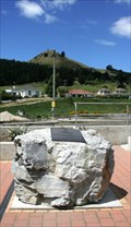 view gallery view galleryE10.9 km |  Sir John McKenzie — Palmerston, New Zealand Sir John McKenzie — Palmerston, New Zealand
in Citizen Memorials To make the McKenzie Cairn more accessible to people unwilling to climb the steep hillside the business community in Palmerston created this memorial to Sir John McKenzie and placed in the centre of town. posted by: Dunbar Loop location: South Island, New Zealand date approved: 03/09/2010 last visited: 11/22/2012 |
 view gallery view gallery SE11.1 km SE11.1 km
|  Wooden Horse Mailbox. Waikouaiti. Otago. New Zealand. Wooden Horse Mailbox. Waikouaiti. Otago. New Zealand.
in Themed Homemade Mailboxes A brown and white wooden horse greets the mailman in Beach Road, Waikouaiti. The mailbox has been cleverly handcrafted into a horse. posted by:  Punga and Paua Punga and Paua location: South Island, New Zealand date approved: 12/03/2009 last visited: 04/28/2013 |
 view gallery view gallery S18 km S18 km
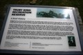
|  Truby King Recreation Reserve — Seacliff, New Zealand Truby King Recreation Reserve — Seacliff, New Zealand
in Signs of History A history of the Seacliff Lunatic Asylum and Sir Truby King's involvement posted by: Dunbar Loop location: New Zealand date approved: 12/05/2009 last visited: never |
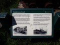 view gallery view galleryE20 km | Undersea Coal — Shag Point, New Zealand in Signs of History The coal seams at Shag Point produced a coal mining industry that operated for over 100 years and yielded some 400,000 tonnes of coal. posted by: Dunbar Loop location: South Island, New Zealand date approved: 03/09/2010 last visited: never |
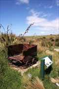 view gallery view galleryE20 km |  Shag Point Coal Mine — Shag Point, New Zealand Shag Point Coal Mine — Shag Point, New Zealand
in Mines The Shag Point Coal Mine began operation in 1863 when D. Hutchinson started commercial extractions. It continued operating until the 1970s producing some 400,000 tonnes of coal. posted by: Dunbar Loop location: South Island, New Zealand date approved: 03/11/2010 last visited: never |
 view gallery view gallery NE20 km NE20 km
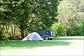
|  Trotters Gorge Scenic Reserve — Otago, New Zealand Trotters Gorge Scenic Reserve — Otago, New Zealand
in Campgrounds A scenic location with easy walking tracks for camping. Worth even stopping for a break on the journey between Christchurch and Dunedin. It is only 5 km off of State Highway 1. posted by: Dunbar Loop location: South Island, New Zealand date approved: 11/25/2009 last visited: 11/15/2010 |
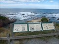 view gallery view galleryE20 km |  Shag Point/Matakaea - near Palmerston, New Zealand Shag Point/Matakaea - near Palmerston, New Zealand
in Maori Historic Sites Shag Point/Matakaea is located about 9 km north of Palmerston. The site has significant cultural significance for Ngai Tahu. The posted coordinates are for the information signs. posted by: Marine Biologist location: South Island, New Zealand date approved: 03/04/2020 last visited: 03/19/2021 |
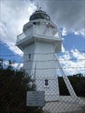 view gallery view galleryNE26.1 km |  Katiki Point Lighthouse - Katiki Point, New Zealand Katiki Point Lighthouse - Katiki Point, New Zealand
in Coastal Lighthouses The Katiki Point Lighthouse is also known as Moeraki Lighthouse. posted by: Marine Biologist location: South Island, New Zealand date approved: 09/30/2020 last visited: never |
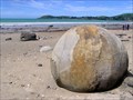 view gallery view galleryNE26.9 km |  Moeraki Boulders. Otago. New Zealand. Moeraki Boulders. Otago. New Zealand.
in Places of Geologic Significance Scattered along the beach at Moeraki, south of Hampden, some 40 kilometers south of Oamaru, these giant boulders are a popular visitor attraction. posted by: Punga and Paua location: South Island, New Zealand date approved: 12/03/2009 last visited: 12/13/2022 |
 view gallery view galleryNE28.5 km |  Hampden Skate Park — Hampden, New Zealand Hampden Skate Park — Hampden, New Zealand
in Skateparks A simple plywood half pipe in a stunning setting in an oceanfront park. posted by: Dunbar Loop location: South Island, New Zealand date approved: 11/25/2009 last visited: never |
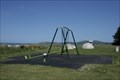 view gallery view galleryNE28.5 km |  Hampden Beach Reserve — Hampden, New Zealand Hampden Beach Reserve — Hampden, New Zealand
in Public Playgrounds A simple playground about 1 km off State Highway 1 between Dunedin and Oamaru offers a good break for young children when travelling. posted by: Dunbar Loop location: South Island, New Zealand date approved: 11/25/2009 last visited: never |
 view gallery view galleryS30.4 km |  Pathway of the Sea — Aramoana, New Zealand Pathway of the Sea — Aramoana, New Zealand
in Welcome Signs Welcome to Aramoana -- Pathway of the Sea posted by: Dunbar Loop location: South Island, New Zealand date approved: 10/28/2009 last visited: 07/07/2012 |
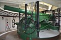 view gallery view galleryS30.7 km |  Fort Taiaroa (Including six-inch Armstrong Hydropneumatic Gun and Underground Chambers) - Dunedin, South Island, New Zealand Fort Taiaroa (Including six-inch Armstrong Hydropneumatic Gun and Underground Chambers) - Dunedin, South Island, New Zealand
in New Zealand Historic Places Located within the Royal Albatoss Centre on the Taiaroa Head at the end of the Otago Peninsula, historic Fort Taiaroa is a warren of tunnels and gun emplacements originally built in 1885 when an attack from Tsarist Russia was feared. posted by: heringermr location: South Island, New Zealand date approved: 01/28/2012 last visited: 06/07/2012 |
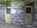 view gallery view galleryS30.9 km |  Taiaroa Head Jail - Harington Point, Otago, New Zealand Taiaroa Head Jail - Harington Point, Otago, New Zealand
in Retired Prisons Now part of the Royal Albatross Centre, this stone jail is the only surviving part of the barracks and prison that occupied this area. posted by: Trail Blaisers location: South Island, New Zealand date approved: 01/05/2014 last visited: never |
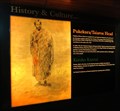
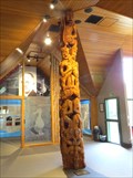 view gallery view galleryS31.1 km | Poutokomanawa - Dunedin, New Zealand in Maori Historic Sites This Poutokomanawa (Maori Post Figure) stands in the reception area at the Royal Albatros Center in Dunedin. It commemorates the signing of the Treaty of Waltangi in 1840. posted by: denben location: South Island, New Zealand date approved: 12/01/2014 last visited: 03/21/2024 |
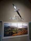 view gallery view galleryS31.1 km |  Royal Albatross Centre - Harington Point, Otago, New Zealand Royal Albatross Centre - Harington Point, Otago, New Zealand
in Wildlife Museums The Royal Albatross Centre is the only mainland place in the world to view Northern Royal Albatrosses in their natural habitat. The tour includes an expert presentation, and access to the interpretation centre and albatross viewing area. posted by: Trail Blaisers location: South Island, New Zealand date approved: 01/04/2014 last visited: 03/17/2024 |
 view gallery view galleryS31.1 km | Pukekura (Taiaroa Head) Pa - Dunedin, New Zealand in Maori Historic Sites Pukekura (Taiaroa Head) is a headland at the end of the Otago Peninsula overlooking the mouth of the Otago Harbour. It lies within the city limits of Dunedin. posted by: denben location: South Island, New Zealand date approved: 12/03/2014 last visited: 03/17/2024 |
 view gallery view galleryS31.1 km |  ONLY Mainland Royal Albatross Colony in the World - Dunedin, New Zealand ONLY Mainland Royal Albatross Colony in the World - Dunedin, New Zealand
in Superlatives The Royal Albatross Centre provides wildlife and cultural tours of Taiaroa Head where you can visit the world’s only mainland breeding colony of Royal Albatross and see the Little Blue Penguin and the Yellow-Eyed Penguin colonies. posted by: denben location: South Island, New Zealand date approved: 12/03/2014 last visited: 02/05/2013 |
 view gallery view galleryS31.4 km | Torpedo Boat Mole — Deborah Bay, New Zealand in Signs of History A brief discussion of the possible Russian invasion of New Zealand during the 1880s. posted by: Dunbar Loop location: South Island, New Zealand date approved: 10/29/2009 last visited: 07/07/2012 |
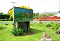
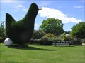 view gallery view galleryNE32.3 km |  The Green Hen. Waianakarua. New Zealand The Green Hen. Waianakarua. New Zealand
in Topiaries A large green hen stands beside the main south highway at Waianakarua, with her freshly layed white egg. posted by: Punga and Paua location: South Island, New Zealand date approved: 04/04/2010 last visited: 04/03/2013 |
|