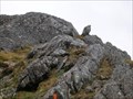
 view gallery view gallery SE3.7 km SE3.7 km
|   Conical Hill, Routeburn Track Conical Hill, Routeburn Track
in Mountain Summits Conical Hill is a steep side trip off the Routeburn Track. posted by:  Zorkin Queen & The Fox Zorkin Queen & The Fox location: South Island, New Zealand date approved: 11/21/2007 last visited: 12/07/2005 |
 view gallery view gallerySE7.1 km |  Routeburn Flats Hut - 700 m - Routeburn Track - New Zealand Routeburn Flats Hut - 700 m - Routeburn Track - New Zealand
in Elevation Signs Elevation listed on sign for hut along the Routeburn Track on the South Island in New Zealand. posted by:  BruceS BruceS location: South Island, New Zealand date approved: 01/06/2013 last visited: never |
 view gallery view gallerySE7.1 km |  Routeburn Flats Hut - Routeburn Track - New Zealand Routeburn Flats Hut - Routeburn Track - New Zealand
in Remote Backcountry Shelters One of four Department of Conservation operated huts along the Routeburn Track on the South Island in New Zealand. posted by: BruceS location: South Island, New Zealand date approved: 01/06/2013 last visited: never |
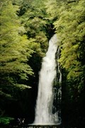 view gallery view gallery N7.9 km N7.9 km
|  Hidden falls - Hollyford Valley Hidden falls - Hollyford Valley
in Waterfalls Tucked away in the rainforest of the Hollyford Valley in the South Island of New Zealand - these falls are certainly worth a look. posted by: StagsRoar location: South Island, New Zealand date approved: 12/06/2005 last visited: never |
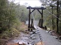
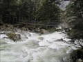 view gallery view gallery E8.2 km E8.2 km
|  Routeburn River Swing Bridge - Routeburn Track - New Zealand Routeburn River Swing Bridge - Routeburn Track - New Zealand
in Hiking Path Footbridges Swing bridge over the Routeburn River on the Routeburn Track on the South Island in New Zealand. posted by: BruceS location: South Island, New Zealand date approved: 01/06/2013 last visited: never |
 view gallery view galleryE8.2 km |  Routeburn River Swing Bridge - Routeburn Track - New Zealand Routeburn River Swing Bridge - Routeburn Track - New Zealand
in Pedestrian Suspension Bridges Swing bridge over the Routeburn River on the Routeburn Track on the South Island in New Zealand. posted by: BruceS location: South Island, New Zealand date approved: 01/06/2013 last visited: never |
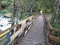 view gallery view galleryE10 km | Unknown Stream and Waterfalls Bridge - Routeburn Track - New Zealand in Hiking Path Footbridges Bridge across an unknown stream on the Routeburn Track in New Zealand. posted by: BruceS location: South Island, New Zealand date approved: 01/06/2013 last visited: never |
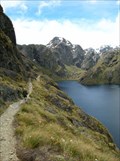
 view gallery view gallery SW10.6 km SW10.6 km
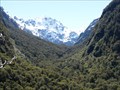
|  Lake Marion Lake Marion
in Scenic Hikes Lake Marion is sited in the Hollyford Valley region of Fiordland, New Zealand. posted by: StagsRoar location: South Island, New Zealand date approved: 06/20/2006 last visited: 12/09/2005 |
 view gallery view galleryE10.8 km | Sugarloaf Stream Swing Bridge - Routeburn Track - New Zealand in Pedestrian Suspension Bridges Swing bridge over stream along the Routeburn Track in New Zealand. posted by: BruceS location: South Island, New Zealand date approved: 01/06/2013 last visited: never |
 view gallery view galleryE10.8 km | Sugarloaf Stream Swing Bridge - Routeburn Track - New Zealand in Hiking Path Footbridges Swing bridge over stream along the Routeburn Track in New Zealand. posted by: BruceS location: South Island, New Zealand date approved: 01/06/2013 last visited: never |
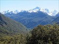
 view gallery view galleryE11.4 km |  The Routeburn Track The Routeburn Track
in Long Distance Hiking Trails The Routeburn Track is located on the South Island in the Southland district. It crosses through parts of Mount Aspiring and Fiordland National Parks covering a distance between Lake Wakatipu and SH94, (Te Anau – Milford Road). posted by: Zorkin Queen & The Fox location: South Island, New Zealand date approved: 01/01/2008 last visited: 02/06/2013 |
 view gallery view gallery S12.2 km S12.2 km
|  Te Anau -Milford Highway Look Out - New Zealand Te Anau -Milford Highway Look Out - New Zealand
in Scenic Roadside Look-Outs Look out along the Te Anau -Milford Highway with view of valley below and the surrounding mountains. posted by: BruceS location: South Island, New Zealand date approved: 01/08/2013 last visited: 02/06/2013 |
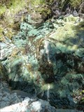 view gallery view galleryS12.4 km |  Water Spring along Routeburn Track - Fiordland, New Zealand Water Spring along Routeburn Track - Fiordland, New Zealand
in Natural Springs I'm not sure about the potability of this water, but you can splash it on your face to cool down as you climb the path towards Key Summit. posted by:  Trail Blaisers Trail Blaisers location: South Island, New Zealand date approved: 01/04/2014 last visited: never |
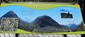 view gallery view galleryS12.4 km |  Pop's View Orientation Table - Milford Sound Highway - New Pop's View Orientation Table - Milford Sound Highway - New
in Orientation Tables Orientation at look out on the Milford Sound Highway on South Island, New Zealand. posted by: BruceS location: South Island, New Zealand date approved: 01/09/2013 last visited: 12/28/2022 |
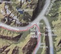 view gallery view galleryS12.4 km |  Pop's View You Are Here Map - Milford Sound Highway - New Zealand Pop's View You Are Here Map - Milford Sound Highway - New Zealand
in 'You Are Here' Maps A you are here map at look out on Milford Sound Highway on South Island, New Zealand. posted by: BruceS location: South Island, New Zealand date approved: 01/09/2013 last visited: 01/26/2019 |
 view gallery view galleryS12.4 km | Pop's View Look Out - Milford Sound Highway - New Zealand in Scenic Roadside Look-Outs Look out on the Milford Sound Highway on South Island, New Zealand. posted by: BruceS location: South Island, New Zealand date approved: 01/09/2013 last visited: 12/28/2022 |
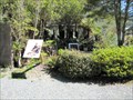
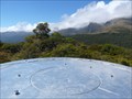 view gallery view galleryS12.7 km | Orientation Table - Key Summit, Fiordland, New Zealand in Orientation Tables This orientation table is located on Key Summit in NZ's beautiful Fiordland District. It takes about a 1.5 hour walk along the Routeburn Track and Key Summit Track to get here from the carpark, but it's worth the effort. posted by: Trail Blaisers location: South Island, New Zealand date approved: 01/05/2014 last visited: never |
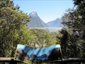
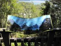
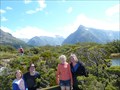 view gallery view galleryS12.7 km | Key Summit - Fiordland, New Zealand in Scenic Overlooks Key Summit isn't the highest in Fiordland, but getting to the top is recognized as one of the best day walks in this part of New Zealand. And the 360 degree panoramic view from here is fantastic! posted by: Trail Blaisers location: South Island, New Zealand date approved: 01/04/2014 last visited: never |
 view gallery view galleryS12.9 km | Howden Hut in Remote Backcountry Shelters Howden Hut is located on the shores of Lake Howden in the Greenstone Valley posted by: StagsRoar location: South Island, New Zealand date approved: 12/22/2005 last visited: 12/09/2005 |
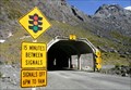 view gallery view gallerySW13.5 km |  SH94 Milford Road. Fiordland. New Zealand. SH94 Milford Road. Fiordland. New Zealand.
in National Scenic Byways Milford Road on SH94 provides the only road access to one of New Zealand’s major tourist attractions – Milford Sound. It is also one of the highest highways in New Zealand, with the highest point of the road reaching 940 metres above sea level. posted by: Punga and Paua location: South Island, New Zealand date approved: 05/07/2009 last visited: 03/18/2024 |
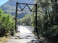 view gallery view gallery W13.7 km W13.7 km
|  Tutoko Suspension Bridge - Milford Highway - New Zealand Tutoko Suspension Bridge - Milford Highway - New Zealand
in Suspension Bridges Historic former highway bridge now open to pedestrians along the Milford Highway a few miles east of the Milford Sound. posted by: BruceS location: South Island, New Zealand date approved: 01/08/2013 last visited: 11/25/2016 |
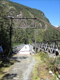 view gallery view galleryW13.7 km |  Tutoko Suspension Bridge - Milford Highway - New Zealand Tutoko Suspension Bridge - Milford Highway - New Zealand
in Orphaned Bridges Historic former highway bridge now open to pedestrians along the Milford Highway a few miles east of the Milford Sound. posted by: BruceS location: South Island, New Zealand date approved: 01/09/2013 last visited: 11/25/2016 |
 view gallery view galleryW16.6 km |  Sutherland Cemetery - Milford Sound, New Zealand Sutherland Cemetery - Milford Sound, New Zealand
in Worldwide Cemeteries Small cemetery in the small community of Milford Sound in South Island, New Zealand. posted by: BruceS location: South Island, New Zealand date approved: 01/09/2013 last visited: never |
 view gallery view galleryW16.7 km | Milford Sound Overlook - Milford Sound, New Zealand in Scenic Overlooks Overlook above the commercial area in Milford Sound. posted by: BruceS location: South Island, New Zealand date approved: 01/08/2013 last visited: never |
 view gallery view galleryW16.7 km | Milford Sound Overlook Orientation Table - Milford Sound, New Zealand in Orientation Tables Orientation at overlook above the commercial area in Milford Sound. posted by: BruceS location: South Island, New Zealand date approved: 01/08/2013 last visited: never |
|