 view gallery view gallery E2.4 km E2.4 km
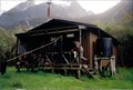
|   Scotts Rock Bivvy Scotts Rock Bivvy
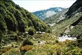
in Remote Backcountry Shelters Scotts Rock Bivvy sits at the Head of the Matukituki Valley under the shadow of Mount Aspiring. posted by:  StagsRoar StagsRoar location: South Island, New Zealand date approved: 12/25/2005 last visited: never |
 view gallery view gallery SE12.9 km SE12.9 km
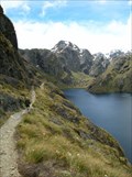
|  Lookout Aspiring Lookout Aspiring
in Scenic Overlooks A fantastic view of Mt Aspiring but requires a bit of effort to be rewarded. posted by:  iguana iguana location: South Island, New Zealand date approved: 05/07/2012 last visited: never |
 view gallery view gallery SW13.8 km SW13.8 km
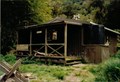
| Dart Hut in Remote Backcountry Shelters Dart Hut is sited near the head of the Dart Valley in the shadow of the Forbes Mountains of Mount Aspiring National Park.
Grid reference: Topo50 map sheet CA10, E1246716, N5060574 posted by: StagsRoar location: South Island, New Zealand date approved: 01/03/2006 last visited: never |
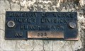 view gallery view galleryE42.3 km |  D 235 (MOW) — Lake Wanaka Lookout, SH 6, Otago, New Zealand D 235 (MOW) — Lake Wanaka Lookout, SH 6, Otago, New Zealand
in Australia/NZ Benchmarks Located in a rock overlooking Lake Wanaka this Order 5 benchmark was installed by the Ministry of Works, Power Division. posted by: Dunbar Loop location: South Island, New Zealand date approved: 01/17/2010 last visited: never |
 view gallery view gallery W42.6 km W42.6 km
| Alabaster Hut in Remote Backcountry Shelters Alabaster hut is part of the Hollyford - Pyke River - Martins Bay walk of Fiordland, New Zealand posted by: StagsRoar location: South Island, New Zealand date approved: 12/24/2005 last visited: never |
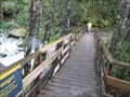
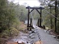 view gallery view gallerySW44.7 km |  Sugarloaf Stream Swing Bridge - Routeburn Track - New Zealand Sugarloaf Stream Swing Bridge - Routeburn Track - New Zealand
in Pedestrian Suspension Bridges Swing bridge over stream along the Routeburn Track in New Zealand. posted by:  BruceS BruceS location: South Island, New Zealand date approved: 01/06/2013 last visited: never |
 view gallery view gallerySW44.7 km |  Sugarloaf Stream Swing Bridge - Routeburn Track - New Zealand Sugarloaf Stream Swing Bridge - Routeburn Track - New Zealand
in Hiking Path Footbridges Swing bridge over stream along the Routeburn Track in New Zealand. posted by: BruceS location: South Island, New Zealand date approved: 01/06/2013 last visited: never |
 view gallery view gallerySW44.7 km |  The Routeburn Track The Routeburn Track
in Long Distance Hiking Trails The Routeburn Track is located on the South Island in the Southland district. It crosses through parts of Mount Aspiring and Fiordland National Parks covering a distance between Lake Wakatipu and SH94, (Te Anau – Milford Road). posted by: Zorkin Queen & The Fox location: South Island, New Zealand date approved: 01/01/2008 last visited: 02/06/2013 |
 view gallery view gallerySW45.1 km | Unknown Stream and Waterfalls Bridge - Routeburn Track - New Zealand in Hiking Path Footbridges Bridge across an unknown stream on the Routeburn Track in New Zealand. posted by: BruceS location: South Island, New Zealand date approved: 01/06/2013 last visited: never |
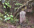 view gallery view gallery N46.7 km N46.7 km
|  Arawhata Cemetery. near Jackson Bay. New Zealand. Arawhata Cemetery. near Jackson Bay. New Zealand.
in Abandoned Cemeteries The Arawhata Pioneer Cemetery is hardly noticeable on the road to Jackson Bay, lost in the dense West Coast bush. There is only a small wooden sign beside a stone memorial, almost hidden on the roadside, to show where this historic place exists. posted by: Punga and Paua location: North Island, New Zealand date approved: 09/26/2009 last visited: 01/12/2010 |
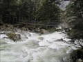 view gallery view gallerySW47.2 km | Routeburn River Swing Bridge - Routeburn Track - New Zealand in Hiking Path Footbridges Swing bridge over the Routeburn River on the Routeburn Track on the South Island in New Zealand. posted by: BruceS location: South Island, New Zealand date approved: 01/06/2013 last visited: never |
 view gallery view gallerySW47.2 km | Routeburn River Swing Bridge - Routeburn Track - New Zealand in Pedestrian Suspension Bridges Swing bridge over the Routeburn River on the Routeburn Track on the South Island in New Zealand. posted by: BruceS location: South Island, New Zealand date approved: 01/06/2013 last visited: never |
 view gallery view galleryW48 km | McKerrow Island Hut in Remote Backcountry Shelters Located on McKerrow Island at the head of Lake McKerrow - South Island of New Zealand posted by: StagsRoar location: South Island, New Zealand date approved: 12/23/2005 last visited: never |
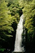 view gallery view gallerySW48.1 km |  Hidden falls - Hollyford Valley Hidden falls - Hollyford Valley
in Waterfalls Tucked away in the rainforest of the Hollyford Valley in the South Island of New Zealand - these falls are certainly worth a look. posted by: StagsRoar location: South Island, New Zealand date approved: 12/06/2005 last visited: never |
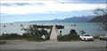
 view gallery view galleryE48.4 km |  Lake Hawea - Otago Region, New Zealand Lake Hawea - Otago Region, New Zealand
in Wikipedia Entries Lake Hawea is located in the Otago Region of New Zealand, at an altitude of 348 metres. Its name is Maori and is thought to be named after a local tribe though the exact meaning is uncertain. posted by: denben location: South Island, New Zealand date approved: 01/28/2015 last visited: 12/27/2022 |
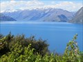 view gallery view galleryE48.4 km |  Lake Hawea - Otago Region, New Zealand Lake Hawea - Otago Region, New Zealand
in Natural Lakes Lake Hawea is located in the Otago Region of New Zealand, at an altitude of 348 metres. Its name is Maori and is thought to be named after a local tribe though the exact meaning is uncertain. posted by: denben location: South Island, New Zealand date approved: 01/28/2015 last visited: 04/17/2024 |
 view gallery view gallerySW48.6 km | Routeburn Flats Hut - Routeburn Track - New Zealand in Remote Backcountry Shelters One of four Department of Conservation operated huts along the Routeburn Track on the South Island in New Zealand. posted by: BruceS location: South Island, New Zealand date approved: 01/06/2013 last visited: never |
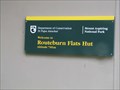 view gallery view gallerySW48.6 km |  Routeburn Flats Hut - 700 m - Routeburn Track - New Zealand Routeburn Flats Hut - 700 m - Routeburn Track - New Zealand
in Elevation Signs Elevation listed on sign for hut along the Routeburn Track on the South Island in New Zealand. posted by: BruceS location: South Island, New Zealand date approved: 01/06/2013 last visited: never |
 view gallery view gallerySE49.2 km |  Roys Bay Playground — Wanaka, New Zealand Roys Bay Playground — Wanaka, New Zealand
in Public Playgrounds A very popular playground on the shores of Lake Wanaka and adjacent to the CBD. It features a large dinosaur slide that is very popular with children. posted by: Dunbar Loop location: South Island, New Zealand date approved: 02/27/2010 last visited: 02/03/2015 |
 view gallery view gallerySE49.2 km |  The Hand that Nurtures — Wanaka, New Zealand The Hand that Nurtures — Wanaka, New Zealand
in Figurative Public Sculpture Created by Llew Summers The Hand That Nurtures is very popular with children who enjoy climbing it. posted by: Dunbar Loop location: South Island, New Zealand date approved: 02/27/2010 last visited: 02/02/2015 |
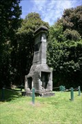 view gallery view galleryN49.2 km |  3-sided Chimney — Jackson Bay, New Zealand 3-sided Chimney — Jackson Bay, New Zealand
in Lonely Chimneys Obscured from the road by some dense bush, this chimney is on a small bluff overlooking the fishing wharf of this small coastal community. posted by: Dunbar Loop location: South Island, New Zealand date approved: 01/17/2010 last visited: never |
 view gallery view galleryN49.4 km |  Jackson Bay Wharf — Jackson Bay, New Zealand Jackson Bay Wharf — Jackson Bay, New Zealand
in Piers The Jackson Bay Wharf is used for commercial and recreational fishing alike. It also provides visitors an opportunity to get an impressive view the scenic fishing village that remains here. posted by: Dunbar Loop location: South Island, New Zealand date approved: 01/19/2010 last visited: 01/18/2015 |
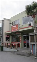 view gallery view gallerySE49.4 km |  Soulfood — Wanaka, New Zealand Soulfood — Wanaka, New Zealand
in Natural/Organic Food Stores A well stocked organic shop in Wanaka that also has a café. posted by: Dunbar Loop location: South Island, New Zealand date approved: 01/20/2010 last visited: 11/16/2014 |
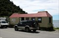 view gallery view galleryN49.4 km |  The Cray Pot — Jackson Bay, New Zealand The Cray Pot — Jackson Bay, New Zealand
in Fish and Chips Restaurants In this fishing hamlet you do get the fish of day at The Cray Pot posted by: Dunbar Loop location: South Island, New Zealand date approved: 03/03/2010 last visited: 03/12/2010 |
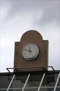 view gallery view gallerySE49.4 km |  Clock on Dunmore Street — Wanaka, New Zealand Clock on Dunmore Street — Wanaka, New Zealand
in Town Clocks This two-sided clock is atop a small shopping complex. posted by: Dunbar Loop location: South Island, New Zealand date approved: 02/23/2010 last visited: 11/16/2014 |
|