 view gallery view gallery SW22.4 km SW22.4 km
|   Scotts Rock Bivvy Scotts Rock Bivvy
in Remote Backcountry Shelters Scotts Rock Bivvy sits at the Head of the Matukituki Valley under the shadow of Mount Aspiring. posted by:  StagsRoar StagsRoar location: South Island, New Zealand date approved: 12/25/2005 last visited: never |
 view gallery view gallery S29.8 km S29.8 km
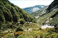
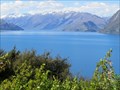
|  Lookout Aspiring Lookout Aspiring
in Scenic Overlooks A fantastic view of Mt Aspiring but requires a bit of effort to be rewarded. posted by:  iguana iguana location: South Island, New Zealand date approved: 05/07/2012 last visited: never |
 view gallery view gallery NW31.9 km NW31.9 km
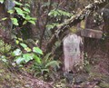
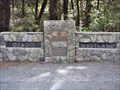
|  Arawhata Cemetery. near Jackson Bay. New Zealand. Arawhata Cemetery. near Jackson Bay. New Zealand.
in Abandoned Cemeteries The Arawhata Pioneer Cemetery is hardly noticeable on the road to Jackson Bay, lost in the dense West Coast bush. There is only a small wooden sign beside a stone memorial, almost hidden on the roadside, to show where this historic place exists. posted by: Punga and Paua location: North Island, New Zealand date approved: 09/26/2009 last visited: 01/12/2010 |
 view gallery view gallery SE34.3 km SE34.3 km
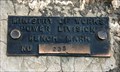
|  D 235 (MOW) — Lake Wanaka Lookout, SH 6, Otago, New Zealand D 235 (MOW) — Lake Wanaka Lookout, SH 6, Otago, New Zealand
in Australia/NZ Benchmarks Located in a rock overlooking Lake Wanaka this Order 5 benchmark was installed by the Ministry of Works, Power Division. posted by: Dunbar Loop location: South Island, New Zealand date approved: 01/17/2010 last visited: never |
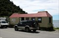
 view gallery view galleryNW35.2 km |  Jackson Bay Wharf — Jackson Bay, New Zealand Jackson Bay Wharf — Jackson Bay, New Zealand
in Piers The Jackson Bay Wharf is used for commercial and recreational fishing alike. It also provides visitors an opportunity to get an impressive view the scenic fishing village that remains here. posted by: Dunbar Loop location: South Island, New Zealand date approved: 01/19/2010 last visited: 01/18/2015 |
 view gallery view galleryNW35.4 km |  3-sided Chimney — Jackson Bay, New Zealand 3-sided Chimney — Jackson Bay, New Zealand
in Lonely Chimneys Obscured from the road by some dense bush, this chimney is on a small bluff overlooking the fishing wharf of this small coastal community. posted by: Dunbar Loop location: South Island, New Zealand date approved: 01/17/2010 last visited: never |
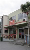
 view gallery view galleryNW35.4 km |  The Cray Pot — Jackson Bay, New Zealand The Cray Pot — Jackson Bay, New Zealand
in Fish and Chips Restaurants In this fishing hamlet you do get the fish of day at The Cray Pot posted by: Dunbar Loop location: South Island, New Zealand date approved: 03/03/2010 last visited: 03/12/2010 |
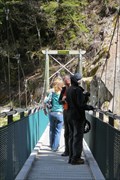 view gallery view gallery E36.4 km E36.4 km
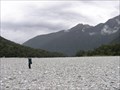
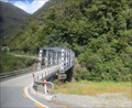
|  Blue Pools Swinging Bridge - Mount Aspiring National Park, South Island, New Zealand Blue Pools Swinging Bridge - Mount Aspiring National Park, South Island, New Zealand
in Pedestrian Suspension Bridges Access to the Blue Pools swinging bridge is from the Blue Pools car park, off the Haast Highway (SH6) about 8 km from the township of Makarora on the West Coast of New Zealand. posted by: denben location: South Island, New Zealand date approved: 01/28/2015 last visited: 01/28/2015 |
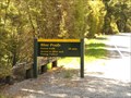 view gallery view galleryE36.5 km |  Blue Pools Forest Walk - Mount Aspiring National Park, South Island, New Zealand Blue Pools Forest Walk - Mount Aspiring National Park, South Island, New Zealand
in Hiking and walking trailheads Access to the Blue Pools Forest walk is from the Blue Pools car park, off the Haast Highway (SH6) about 8 km from the township of Makarora on the West Coast of New Zealand. posted by: denben location: South Island, New Zealand date approved: 01/31/2015 last visited: never |
 view gallery view gallerySW37.5 km | Dart Hut in Remote Backcountry Shelters Dart Hut is sited near the head of the Dart Valley in the shadow of the Forbes Mountains of Mount Aspiring National Park.
Grid reference: Topo50 map sheet CA10, E1246716, N5060574 posted by: StagsRoar location: South Island, New Zealand date approved: 01/03/2006 last visited: never |
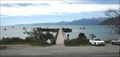
 view gallery view gallerySE43.8 km |  Lake Hawea - Otago Region, New Zealand Lake Hawea - Otago Region, New Zealand
in Wikipedia Entries Lake Hawea is located in the Otago Region of New Zealand, at an altitude of 348 metres. Its name is Maori and is thought to be named after a local tribe though the exact meaning is uncertain. posted by: denben location: South Island, New Zealand date approved: 01/28/2015 last visited: 12/27/2022 |
 view gallery view gallerySE43.8 km |  Lake Hawea - Otago Region, New Zealand Lake Hawea - Otago Region, New Zealand
in Natural Lakes Lake Hawea is located in the Otago Region of New Zealand, at an altitude of 348 metres. Its name is Maori and is thought to be named after a local tribe though the exact meaning is uncertain. posted by: denben location: South Island, New Zealand date approved: 01/28/2015 last visited: 04/17/2024 |
 view gallery view galleryE44.4 km |  Westland - Otago Boundary on Haast Pass. South Is. New Zealand. Westland - Otago Boundary on Haast Pass. South Is. New Zealand.
in Border Crossings The border of Westland and Otago districts is crossed as you drive over the Haast Pass, a mountain pass in the Southern Alps linking the rugged West Coast of the South Island to the beautiful Wanaka Lake district in Central Otago. posted by: Punga and Paua location: South Island, New Zealand date approved: 09/19/2013 last visited: 01/17/2015 |
 view gallery view gallery N46.5 km N46.5 km
|  Te Wahipounamu, Westland, New Zealand Te Wahipounamu, Westland, New Zealand
in World Heritage Sites A beautiful region of the South Island of New Zealand. posted by: The Spindoctors location: South Island, New Zealand date approved: 01/07/2009 last visited: 02/02/2015 |
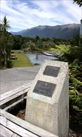
 view gallery view galleryN46.5 km |  John Mitchell 1942 – 2005 — Haast Junction, New Zealand John Mitchell 1942 – 2005 — Haast Junction, New Zealand
in Citizen Memorials An expansive wetland created out of a "wet paddock" is dedicated to conservation work and the memory of John Mitchell. posted by: Dunbar Loop location: South Island, New Zealand date approved: 01/19/2010 last visited: 01/18/2015 |
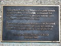
 view gallery view galleryN46.5 km | Hunters and Pilots of the Deer Recovery and Venison Industry — Haast Junction, New Zealand in Citizen Memorials After deer was introduced to the wild in the 1800s enormous enviornmental damage happened throughout the high country. Starting in the 1950s deer was hunted or removed to be farmed. This memorial remembers the many people who died in this process. posted by: Dunbar Loop location: South Island, New Zealand date approved: 01/19/2010 last visited: 01/18/2015 |
 view gallery view galleryN46.5 km |  Deer, Chamois and Thar — Haast Junction, New Zealand Deer, Chamois and Thar — Haast Junction, New Zealand
in Signs of History Recognising the damaged that the introduced deer, chamois, and thar had done to the high country, there was a national programme to remove these animals. Today most of them are farmed as venison. posted by: Dunbar Loop location: South Island, New Zealand date approved: 01/18/2010 last visited: 01/18/2015 |
 view gallery view galleryN46.5 km |  LONGEST Running de Havilland Biplane Air Service — Haast Junction, New Zealand LONGEST Running de Havilland Biplane Air Service — Haast Junction, New Zealand
in Superlatives Staring in 1934 and running until 1967, Haast was service with the world's longest running de Havilland biplane scheduled air service. posted by: Dunbar Loop location: South Island, New Zealand date approved: 02/25/2010 last visited: 01/18/2015 |
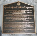 view gallery view galleryN46.5 km |  FIRST — New Zealand’s First Licensed Scheduled Air Service — Haast Junction, New Zealand FIRST — New Zealand’s First Licensed Scheduled Air Service — Haast Junction, New Zealand
in First of its Kind In 1934 Bert Mercer took off in Hokitika and flew to Haast inaugurating New Zealand’s First Licensed Scheduled Air Service. This service lasted until the late 1960s when the Haast Highway provided an alternative to air travel to South Westland. posted by: Dunbar Loop location: South Island, New Zealand date approved: 01/18/2010 last visited: 01/18/2015 |
 view gallery view galleryN46.5 km | New Zealand’s First Licensed Scheduled Air Service — Haast Junction, New Zealand in Signs of History An overview of New Zealand's first scheduled air service and the impact it had on South Westland, an isolated part of the nation. posted by: Dunbar Loop location: South Island, New Zealand date approved: 01/18/2010 last visited: 01/18/2015 |
 view gallery view gallery NE49.4 km NE49.4 km
| Haast Pass - Southern Alps, Mount Aspiring National Park, New Zealand in Wikipedia Entries Haast Pass is a mountain pass in the Southern Alps of the South Island of New Zealand within Mount Aspiring National Park. posted by: denben location: South Island, New Zealand date approved: 01/27/2015 last visited: 02/05/2018 |
 view gallery view gallerySE54.9 km |  Roys Bay Playground — Wanaka, New Zealand Roys Bay Playground — Wanaka, New Zealand
in Public Playgrounds A very popular playground on the shores of Lake Wanaka and adjacent to the CBD. It features a large dinosaur slide that is very popular with children. posted by: Dunbar Loop location: South Island, New Zealand date approved: 02/27/2010 last visited: 02/03/2015 |
 view gallery view gallerySE54.9 km |  The Hand that Nurtures — Wanaka, New Zealand The Hand that Nurtures — Wanaka, New Zealand
in Figurative Public Sculpture Created by Llew Summers The Hand That Nurtures is very popular with children who enjoy climbing it. posted by: Dunbar Loop location: South Island, New Zealand date approved: 02/27/2010 last visited: 02/02/2015 |
 view gallery view gallerySE54.9 km |  Soulfood — Wanaka, New Zealand Soulfood — Wanaka, New Zealand
in Natural/Organic Food Stores A well stocked organic shop in Wanaka that also has a café. posted by: Dunbar Loop location: South Island, New Zealand date approved: 01/20/2010 last visited: 11/16/2014 |
 view gallery view gallerySE55 km |  Locations Clock — Wanaka, New Zealand Locations Clock — Wanaka, New Zealand
in Town Clocks A local real estate agency has a simple clock above the office door. posted by: Dunbar Loop location: South Island, New Zealand date approved: 02/23/2010 last visited: 11/16/2014 |
|