 view gallery view gallery N47.6 km N47.6 km
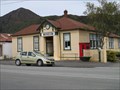
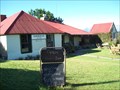
|   Murchison Museum - Murchison, New Zealand Murchison Museum - Murchison, New Zealand
in History Museums This small museum is located on Fairfax Street in Murchison. It opened on 15th December 1989. posted by:  denben denben location: South Island, New Zealand date approved: 01/20/2015 last visited: never |
 view gallery view galleryN47.8 km |  Hodgson's Store and Stables - Murchison, New Zealand Hodgson's Store and Stables - Murchison, New Zealand
in New Zealand Historic Places Hodgson's Store is located on Fairfax Street in Murchison, South Island. The stables are directly behind the store and are accessible via a driveway immediately south of the store. posted by: denben location: South Island, New Zealand date approved: 01/21/2015 last visited: 01/23/2015 |
 view gallery view gallery NE48.8 km NE48.8 km
|  D'urville Hut D'urville Hut
in Remote Backcountry Shelters Sited at the head of Lake Rotoroa in the Nelson Lakes Park posted by: StagsRoar location: South Island, New Zealand date approved: 12/28/2005 last visited: never |
 view gallery view galleryN50.1 km |  Buller Gorge Swing Bridge Buller Gorge Swing Bridge
in Pedestrian Suspension Bridges Buller Gorge Swing Bridge, New Zealand's longest foot bridge. posted by: thebigchip location: New Zealand date approved: 05/04/2009 last visited: 03/13/2024 |
 NE51.5 km | John Tait Hut - Travers Valley _ Nelson Lakes National Park in Remote Backcountry Shelters A serviced DoC Hut in the Travers Valley posted by:  madiecacher madiecacher location: South Island, New Zealand date approved: 07/28/2008 last visited: never |
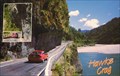 view gallery view gallery NW55.5 km NW55.5 km
|  Hawks Crag, Buller Gorge. New Zealand. Hawks Crag, Buller Gorge. New Zealand.
in Picture Perfect Postcards Postcard showing the road through the forbidding Buller Gorge. At Hawks Crag the road has been hacked out of solid rock – you’ll drive under a dramatic overhang. posted by: Punga and Paua location: North Island, New Zealand date approved: 10/08/2009 last visited: 03/15/2024 |
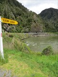 view gallery view galleryNW55.5 km |  Kilkenny Lookout - Lower Buller, West Coast, New Zealand Kilkenny Lookout - Lower Buller, West Coast, New Zealand
in Scenic Roadside Look-Outs Kilkenny Lookout is located on Lower Buller Gorge Road (State Highway 6) near Westport. posted by: denben location: South Island, New Zealand date approved: 01/20/2015 last visited: 03/15/2024 |
 view gallery view gallery SE58.3 km SE58.3 km
|  The Hanmer Springs Gasometer, The Hanmer Springs Gasometer,
in Gasometers This gasometer was commisioned in 1898 and supplied gas to the sanitorium. It was decommisioned in 1940 when the town was connected to the national grid. posted by: greysman location: South Island, New Zealand date approved: 03/27/2011 last visited: 03/07/2013 |
 view gallery view galleryNE61.6 km | Lake Head Hut - Travers Valley in Remote Backcountry Shelters Located at the head of Lake Rotoiti at the outlet of the Travers River posted by: StagsRoar location: South Island, New Zealand date approved: 12/27/2005 last visited: never |
NE63.9 km | Relax Shelter - Mount Robert_Nelson Lakes National Park_NZ in Remote Backcountry Shelters A DoC shelter on Mount Robert, Nelson Lakes National Park posted by: madiecacher location: South Island, New Zealand date approved: 08/03/2008 last visited: 01/23/2010 |
NE64.2 km | Bushedge Shelter - Mount Robert_Nelson Lakes National Park NZ in Remote Backcountry Shelters A DoC shelter on the "Pinchgut" track up Mount Robert posted by: madiecacher location: South Island, New Zealand date approved: 08/03/2008 last visited: 01/23/2010 |
NE64.5 km | Bushline Hut - Mount Robert_Nelson Lakes National Park_NZ in Remote Backcountry Shelters A serviced DoC hut in Nelson Lakes National Park posted by: madiecacher location: South Island, New Zealand date approved: 08/03/2008 last visited: 01/08/2011 |
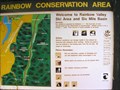 view gallery view galleryNE65.7 km |  You Are Here at Rainbow Conservation Area. South Is. New Zealand. You Are Here at Rainbow Conservation Area. South Is. New Zealand.
in 'You Are Here' Maps "You Are Here" at the base of the Rainbow Ski Field Road in the Six Mile Basin at Rainbow Conservation Area. posted by: Punga and Paua location: South Island, New Zealand date approved: 04/30/2009 last visited: 04/30/2009 |
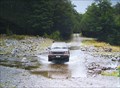 view gallery view galleryNE65.8 km |  Six Mile Creek. Rainbow Valley. South Is. New Zealand. Six Mile Creek. Rainbow Valley. South Is. New Zealand.
in Bridgeless Water Crossings Six Mile Creek crosses the wilderness Rainbow Road linking St Arnaud and Hanmer Springs. There is a rough ford where the road crosses the stream just past the Rainbow Ski Area turn-off, 26 km from the Wairau Valley road end. posted by: Punga and Paua location: South Island, New Zealand date approved: 04/30/2009 last visited: 09/05/2009 |
NE68.1 km |  Kerr Bay Webcam Kerr Bay Webcam
in Web Cameras This webcam owned by the TDC is locally known as the Kerr Bay Webcam. posted by: 360 Degrees NZ location: South Island, New Zealand date approved: 10/14/2012 last visited: never |
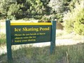 view gallery view galleryNE68.6 km |  Slip Sliding Away in St Arnaud Slip Sliding Away in St Arnaud
in Ice Skating Rinks Ice skating pond in the Nelson Lakes National Park posted by: No Fixed Aboder location: South Island, New Zealand date approved: 02/10/2010 last visited: never |
 view gallery view galleryNE72.7 km | Tophouse Route - New Zealand in New Zealand Historic Places A monument for the Tophouse route discovery posted by: CoinsAndPins location: South Island, New Zealand date approved: 02/13/2007 last visited: 01/30/2010 |
 view gallery view galleryNE74.8 km |  Tophouse Homestead Historic Bed & Breakfast - Tophouse, New Zealand Tophouse Homestead Historic Bed & Breakfast - Tophouse, New Zealand
in Bed and Breakfast Enjoy fine food, licenced premises, a bed and trip down memory lane at the old Tophouse Hotel. posted by: No Fixed Aboder location: South Island, New Zealand date approved: 03/30/2010 last visited: never |
 view gallery view galleryNE74.8 km |  Tragedy at Tophouse - St Arnaud, New Zealand Tragedy at Tophouse - St Arnaud, New Zealand
in Ghosts and Hauntings Two tragic events occured at Tophouse... posted by: No Fixed Aboder location: South Island, New Zealand date approved: 03/21/2010 last visited: never |
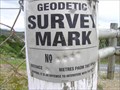 view gallery view gallery W75.2 km W75.2 km
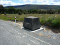
|  Geodetic Survey Mark ACQY, Meybille Bay, New Zealand Geodetic Survey Mark ACQY, Meybille Bay, New Zealand
in Australia/NZ Benchmarks A survey marker on a lookout with great views of the West Coast of South Island. posted by: The Spindoctors location: South Island, New Zealand date approved: 01/21/2014 last visited: 11/05/2014 |
 view gallery view galleryW76.3 km | Punakaiki Resort - Punakaiki, New Zealand in Recommended Accommodation Punakaiki Resort is located on New Zealand's wild West Coast at about 350m south of the famous Pancakes Rocks and Blowholes. posted by: denben location: South Island, New Zealand date approved: 01/21/2015 last visited: 01/23/2015 |
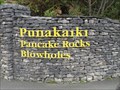 view gallery view galleryW76.3 km |  Pancake Rocks & Blowholes - Dolomite Point - Punakaiki, New Zealand Pancake Rocks & Blowholes - Dolomite Point - Punakaiki, New Zealand
in Official Local Tourism Attractions The entrance to Pancake Rocks & Blowholes is located opposite the Paparoa National Park Visitors Centre at Dolomite Point, Punakaiki, West Coast. posted by: denben location: South Island, New Zealand date approved: 01/20/2015 last visited: 11/19/2016 |
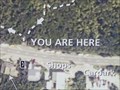 view gallery view galleryW76.3 km | You Are Here - Pancake Rocks & Blowholes - Punakaiki, New Zealand in 'You Are Here' Maps Map at the entrance to Pancake Rocks & Blowholes located opposite the Paparoa National Park Visitors Centre at Dolomite Point, Punakaiki, West Coast. posted by: denben location: South Island, New Zealand date approved: 01/21/2015 last visited: 03/15/2024 |
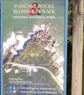 view gallery view galleryW76.3 km |  Pancake Rocks & Blowholes Walk - Paparoa National Park - Punakaiki, New Zealand Pancake Rocks & Blowholes Walk - Paparoa National Park - Punakaiki, New Zealand
in Hiking and walking trailheads The Pancake Rocks & Blowholes Trailhead is located at the entrance to Pancake Rocks & Blowholes opposite the Paparoa National Park Visitors Centre at Dolomite Point, Punakaiki, West Coast. posted by: denben location: South Island, New Zealand date approved: 01/21/2015 last visited: 11/19/2016 |
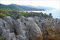 view gallery view galleryW76.3 km |  Pancake Rocks. Punakaiki. West Coast. New Zealand. Pancake Rocks. Punakaiki. West Coast. New Zealand.
in Places of Geologic Significance The famous Pancake Rocks and Blowholes are just a 20 minute loop walk from where you park your vehicle on the main highway at Punakaiki on the West Coast of the South Island. posted by: Punga and Paua location: New Zealand date approved: 07/21/2008 last visited: 03/15/2024 |
|