 view gallery view gallery SW4.2 km SW4.2 km
|   Tragedy at Tophouse - St Arnaud, New Zealand Tragedy at Tophouse - St Arnaud, New Zealand
in Ghosts and Hauntings Two tragic events occured at Tophouse... posted by:  No Fixed Aboder No Fixed Aboder location: South Island, New Zealand date approved: 03/21/2010 last visited: never |
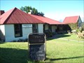
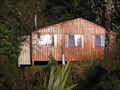
 view gallery view gallerySW4.2 km |  Tophouse Homestead Historic Bed & Breakfast - Tophouse, New Zealand Tophouse Homestead Historic Bed & Breakfast - Tophouse, New Zealand
in Bed and Breakfast Enjoy fine food, licenced premises, a bed and trip down memory lane at the old Tophouse Hotel. posted by: No Fixed Aboder location: South Island, New Zealand date approved: 03/30/2010 last visited: never |
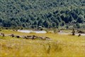
 view gallery view gallery S4.3 km S4.3 km
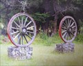
|  Wagon Wheels, Rainbow Skifield Road. South Island . New Zealand. Wagon Wheels, Rainbow Skifield Road. South Island . New Zealand.
in Wagon Wheels Two old wagon wheels rest beside the road on the way to the Rainbow Skifield near Nelson Lakes in the upper South Island. posted by: Punga and Paua location: South Island, New Zealand date approved: 09/23/2008 last visited: 09/23/2008 |
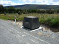 view gallery view gallerySW6.6 km |  Tophouse Route - New Zealand Tophouse Route - New Zealand
in New Zealand Historic Places A monument for the Tophouse route discovery posted by: CoinsAndPins location: South Island, New Zealand date approved: 02/13/2007 last visited: 01/30/2010 |
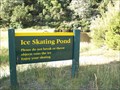 view gallery view gallerySW10.6 km |  Slip Sliding Away in St Arnaud Slip Sliding Away in St Arnaud
in Ice Skating Rinks Ice skating pond in the Nelson Lakes National Park posted by: No Fixed Aboder location: South Island, New Zealand date approved: 02/10/2010 last visited: never |
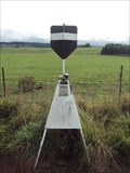
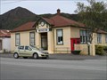
 SW10.9 km |  Kerr Bay Webcam Kerr Bay Webcam
in Web Cameras This webcam owned by the TDC is locally known as the Kerr Bay Webcam. posted by: 360 Degrees NZ location: South Island, New Zealand date approved: 10/14/2012 last visited: never |
SW14.6 km |  Bushline Hut - Mount Robert_Nelson Lakes National Park_NZ Bushline Hut - Mount Robert_Nelson Lakes National Park_NZ
in Remote Backcountry Shelters A serviced DoC hut in Nelson Lakes National Park posted by: madiecacher location: South Island, New Zealand date approved: 08/03/2008 last visited: 01/08/2011 |
SW15 km | Bushedge Shelter - Mount Robert_Nelson Lakes National Park NZ in Remote Backcountry Shelters A DoC shelter on the "Pinchgut" track up Mount Robert posted by: madiecacher location: South Island, New Zealand date approved: 08/03/2008 last visited: 01/23/2010 |
SW15.3 km | Relax Shelter - Mount Robert_Nelson Lakes National Park_NZ in Remote Backcountry Shelters A DoC shelter on Mount Robert, Nelson Lakes National Park posted by: madiecacher location: South Island, New Zealand date approved: 08/03/2008 last visited: 01/23/2010 |
 view gallery view gallerySW18.3 km | Lake Head Hut - Travers Valley in Remote Backcountry Shelters Located at the head of Lake Rotoiti at the outlet of the Travers River posted by:  StagsRoar StagsRoar location: South Island, New Zealand date approved: 12/27/2005 last visited: never |
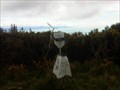
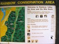 view gallery view galleryS19.5 km |  You Are Here at Rainbow Conservation Area. South Is. New Zealand. You Are Here at Rainbow Conservation Area. South Is. New Zealand.
in 'You Are Here' Maps "You Are Here" at the base of the Rainbow Ski Field Road in the Six Mile Basin at Rainbow Conservation Area. posted by: Punga and Paua location: South Island, New Zealand date approved: 04/30/2009 last visited: 04/30/2009 |
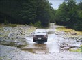 view gallery view galleryS19.6 km |  Six Mile Creek. Rainbow Valley. South Is. New Zealand. Six Mile Creek. Rainbow Valley. South Is. New Zealand.
in Bridgeless Water Crossings Six Mile Creek crosses the wilderness Rainbow Road linking St Arnaud and Hanmer Springs. There is a rough ford where the road crosses the stream just past the Rainbow Ski Area turn-off, 26 km from the Wairau Valley road end. posted by: Punga and Paua location: South Island, New Zealand date approved: 04/30/2009 last visited: 09/05/2009 |
 view gallery view gallery N21.1 km N21.1 km
| Wheely Good Wheels - Golden Downs, South Island, New Zealand in Wagon Wheels Located in the paddock in front of the Nelson Pistol Club. posted by: No Fixed Aboder location: North Island, New Zealand date approved: 03/21/2010 last visited: never |
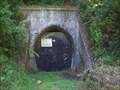 view gallery view galleryN27.4 km |  Spooners Rail Tunnel, South Island, New Zealand Spooners Rail Tunnel, South Island, New Zealand
in Abandoned Train Tunnels The longest disused rail tunnel in New Zealand posted by: No Fixed Aboder location: South Island, New Zealand date approved: 02/14/2010 last visited: 04/13/2011 |
 view gallery view galleryN27.4 km |  Longest -- Disused Rail Tunnel in New Zealand - Nelson, New Zealand Longest -- Disused Rail Tunnel in New Zealand - Nelson, New Zealand
in Superlatives 1352 metres of disused rail tunnel to explore. posted by: No Fixed Aboder location: South Island, New Zealand date approved: 04/30/2010 last visited: 04/13/2011 |
 view gallery view galleryN28.3 km |  88 Valley Trig 88 Valley Trig
in Australia/NZ Benchmarks Roadside trig located in the rural 88 Valley with views to Golden Downs and Ranges beyond . posted by: BigglesNZ location: South Island, New Zealand date approved: 04/25/2011 last visited: 04/26/2011 |
SW30.1 km | John Tait Hut - Travers Valley _ Nelson Lakes National Park in Remote Backcountry Shelters A serviced DoC Hut in the Travers Valley posted by: madiecacher location: South Island, New Zealand date approved: 07/28/2008 last visited: never |
 view gallery view gallerySW30.6 km | D'urville Hut in Remote Backcountry Shelters Sited at the head of Lake Rotoroa in the Nelson Lakes Park posted by: StagsRoar location: South Island, New Zealand date approved: 12/28/2005 last visited: never |
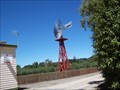 view gallery view galleryN31.7 km |  Belgrove Railway Windmill - Belgrove, New Zealand Belgrove Railway Windmill - Belgrove, New Zealand
in Windmills An excellent example of a wooden railway windmill. posted by: No Fixed Aboder location: South Island, New Zealand date approved: 02/20/2010 last visited: 03/31/2011 |
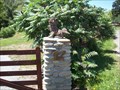 view gallery view galleryN37.2 km |  Guarding the Entrance - Wakefield, South Island, New Zealand Guarding the Entrance - Wakefield, South Island, New Zealand
in Gargoyles and Chimeras Two Gargoyles located at 12 Edward Bagient Memorial Park Rd, State Highway 6, Wakefield, New Zealand. posted by: No Fixed Aboder location: South Island, New Zealand date approved: 02/20/2010 last visited: never |
 view gallery view gallery NE45.5 km NE45.5 km
| Browning Hut in Remote Backcountry Shelters Browning Hut is located in the Richmond State Forest in the Nelson/Marlborough Region. posted by: StagsRoar location: South Island, New Zealand date approved: 01/01/2006 last visited: 12/15/2010 |
 view gallery view galleryN50.1 km | Baton Trig in Australia/NZ Benchmarks Roadside trig located in the remote Baton Valley with views to Kahurangi National Park. posted by: BigglesNZ location: South Island, New Zealand date approved: 05/24/2011 last visited: 04/06/2011 |
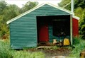
 view gallery view gallery W51 km W51 km
| Hodgson's Store and Stables - Murchison, New Zealand in New Zealand Historic Places Hodgson's Store is located on Fairfax Street in Murchison, South Island. The stables are directly behind the store and are accessible via a driveway immediately south of the store. posted by: denben location: South Island, New Zealand date approved: 01/21/2015 last visited: 01/23/2015 |
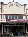
 view gallery view galleryW51 km |  Murchison Museum - Murchison, New Zealand Murchison Museum - Murchison, New Zealand
in History Museums This small museum is located on Fairfax Street in Murchison. It opened on 15th December 1989. posted by: denben location: South Island, New Zealand date approved: 01/20/2015 last visited: never |
 view gallery view galleryNE53.3 km | Jenkins Hill Trig in Australia/NZ Benchmarks Trig Station at the top of Jenkins Hill near Nelson city. posted by: BigglesNZ location: South Island, New Zealand date approved: 10/14/2012 last visited: never |
|