 view gallery view gallery N1.3 km N1.3 km
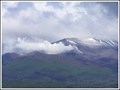
|   Te Maari Craters, Mt Tongariro. New Zealand. Te Maari Craters, Mt Tongariro. New Zealand.
in Volcano Watching After laying dormant for 115 years, Te Maari craters erupted in August and November of 2012 and are still billowing steam and gas from the vents, providing interesting viewing for volcano watchers. posted by:  Punga and Paua Punga and Paua location: North Island, New Zealand date approved: 01/25/2013 last visited: 01/29/2013 |
 view gallery view gallery NW4 km NW4 km
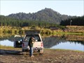
|  Lake Otamangakau. Central Plateau. New Zealand. Lake Otamangakau. Central Plateau. New Zealand.
in Fishing Holes Lake Otamangakau provides wilderness trout fishing on a lake to the south-west of Lake Taupo. Mostly rainbow (some to trophy sizes) but also many large brown trout.
posted by: Punga and Paua location: New Zealand date approved: 05/27/2008 last visited: 05/27/2008 |
 view gallery view gallery W4.2 km W4.2 km
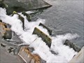
|  Otamangakau Canals, Central Plateau. New Zealand. Otamangakau Canals, Central Plateau. New Zealand.
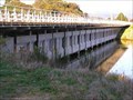
in Fish Ladders Fish steps link the different levels of the canals in the Lake Otamangakau area, part of the Tongariro Hydro Scheme. posted by: Punga and Paua location: North Island, New Zealand date approved: 10/16/2013 last visited: 10/16/2013 |
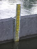
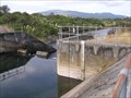 view gallery view galleryW4.2 km |  Otamangakau Canal Gauge. Lake Otamangakau. New Zealand. Otamangakau Canal Gauge. Lake Otamangakau. New Zealand.
in River Gauges A water level gauge is situated above the concrete weir on the Otamangakau Canal near Lake Te Whaiau to measure water levels in the canal system. posted by: Punga and Paua location: North Island, New Zealand date approved: 04/03/2013 last visited: 04/03/2013 |
 view gallery view gallery S5 km S5 km
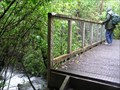
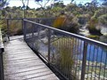
|  Footbridge, Tongariro Alpine Crossing. New Zealand. Footbridge, Tongariro Alpine Crossing. New Zealand.
in Hiking Path Footbridges A footbridge at the Ketetahi end of the famous Tongariro Alpine Crossing over Mt Tongariro. posted by: Punga and Paua location: North Island, New Zealand date approved: 10/04/2009 last visited: 03/08/2024 |
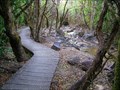 view gallery view galleryS5.3 km |  Ketetahi Track Boardwalk on Mt Tongariro. North Is. New Zealand. Ketetahi Track Boardwalk on Mt Tongariro. North Is. New Zealand.
in Non-Coastal Boardwalks A small section of boardwalk along a walking track on the slopes of Mt Tongariro. posted by: Punga and Paua location: North Island, New Zealand date approved: 03/11/2021 last visited: 03/08/2024 |
 view gallery view gallery E5.6 km E5.6 km
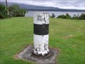
|  Geodetic Survey Mark. Opotaka. Lake Rotoaira. New Zealand. Geodetic Survey Mark. Opotaka. Lake Rotoaira. New Zealand.
in Australia/NZ Benchmarks A cylindrical concrete Land Information New Zealand marker at the historic Opotaka maori village site beside Lake Rotoaira. posted by: Punga and Paua location: North Island, New Zealand date approved: 01/07/2010 last visited: 11/13/2010 |
 view gallery view galleryW5.6 km |  Battle of Te Porere. Central Plateau. New Zealand. Battle of Te Porere. Central Plateau. New Zealand.
in Battlefields The redoubts at Te Porere contain the earthworks of a Maori fortification built by the prophet and warrior Te Kooti and is the site of the last major engagement of the New Zealand Wars on 4th October 1869. posted by: Punga and Paua location: North Island, New Zealand date approved: 03/08/2010 last visited: 03/08/2010 |
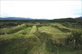 view gallery view galleryW5.6 km |  Te Porere Redoubt. Central Plateau. North Is. New Zealand. Te Porere Redoubt. Central Plateau. North Is. New Zealand.
in Maori Historic Sites Te Porere contains the earthworks of a Maori fortification built by the prophet and warrior Te Kooti and is the site of the last major engagement of the New Zealand Wars in October 1869. posted by: Punga and Paua location: North Island, New Zealand date approved: 11/23/2008 last visited: 11/23/2008 |
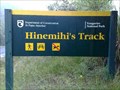 view gallery view galleryE8.9 km |  Hinemihi's Track. Mt Pihanga. New Zealand. Hinemihi's Track. Mt Pihanga. New Zealand.
in Ancient Traces and Roads Hinemihi's Track on Te Ponanga Saddle near Mt Pihanga was part of an early Pre-European Maori trail across the Central Plateau from Wanganui to Taupo. posted by: Punga and Paua location: North Island, New Zealand date approved: 09/04/2009 last visited: 11/13/2010 |
 view gallery view galleryS9.7 km |  "Fear at Tongariro". Mt Tongariro. Nth Is. New Zealand. "Fear at Tongariro". Mt Tongariro. Nth Is. New Zealand.
in News Article Locations The front page news item in our local newspaper reported the recent eruption of Te Maari Craters on Mt Tongariro. posted by: Punga and Paua location: North Island, New Zealand date approved: 01/29/2013 last visited: 03/08/2024 |
 view gallery view galleryW11.1 km | Okupata Caves gauge - Okupata Stream - North Island, New Zealand in River Gauges Gauge of Okupata Stream near Okupata cave posted by: franketmuriel location: North Island, New Zealand date approved: 12/25/2019 last visited: never |
 view gallery view gallery SE11.4 km SE11.4 km
| Poutu Dam River Gauge. Rotoaira. New Zealand. in River Gauges A river gauge at the Poutu Dam measures water levels in the Rotoaira Channel at Lake Rotoaira. posted by: Punga and Paua location: North Island, New Zealand date approved: 09/13/2009 last visited: 11/13/2010 |
 view gallery view gallery NE11.7 km NE11.7 km
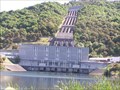
|  Tokaanu Hydroelectric Power Station. Tokaanu. North Is. New Zealand. Tokaanu Hydroelectric Power Station. Tokaanu. North Is. New Zealand.
in Hydroelectric Power Stations The Tokaanu Power Station, part of the Tongariro Hydro Power Scheme, is a 240 MW capacity station situated on the base of Mount Tihia at the southern end of Lake Taupo. posted by: Punga and Paua location: North Island, New Zealand date approved: 01/25/2013 last visited: 01/26/2013 |
 view gallery view galleryNE12.2 km | Tokaanu Geothermal Boardwalk, Tokaanu. North Is. New Zealand. in Non-Coastal Boardwalks Enjoy a free boardwalk through a natural geothermal landscape of marshy swampland, clear waters in steaming hot bubbling pools and boiling mud in the village of Tokaanu. posted by: Punga and Paua location: North Island, New Zealand date approved: 04/08/2019 last visited: 04/08/2019 |
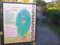 view gallery view galleryNE12.4 km |  You Are Here at the Tokaanu Thermal Walkway. New Zealand. You Are Here at the Tokaanu Thermal Walkway. New Zealand.
in 'You Are Here' Maps YOU ARE HERE at the Tokaanu Thermal area, close to the resting place of a Taniwha. posted by: Punga and Paua location: North Island, New Zealand date approved: 09/09/2009 last visited: 03/03/2010 |
 view gallery view galleryNE12.4 km |  Trout Bridge. Tokaanu. North Is. New Zealand. Trout Bridge. Tokaanu. North Is. New Zealand.
in Man-made Animal Bridges and Crossings A unique aquaduct in Tokaanu, specifically designed to carry the Tokaanu Stream with all its aquatic life and spawning trout. posted by: Punga and Paua location: North Island, New Zealand date approved: 08/30/2018 last visited: 08/30/2018 |
 view gallery view galleryS12.6 km | Tongariro Crossing Boardwalk, Central North Island. New Zealand. in Non-Coastal Boardwalks This section of Boardwalk forms part of the famous great walk, The Tongariro Crossing, which crosses the volcanic Tongariro National Park in the centre of the North Island. posted by: Punga and Paua location: North Island, New Zealand date approved: 11/07/2019 last visited: 03/08/2024 |
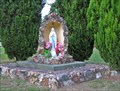 view gallery view galleryNE12.6 km |  Virgin Mary in Tokaanu. Southern Lake Taupo. New Zealand. Virgin Mary in Tokaanu. Southern Lake Taupo. New Zealand.
in Statues of Religious Figures This beautiful little statue of Mary stands on the roadside in the village of Tokaanu in the Southern Lake Taupo district. posted by: Punga and Paua location: North Island, New Zealand date approved: 08/07/2013 last visited: 08/07/2013 |
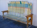 view gallery view galleryNE12.6 km |  Après-Ski Rest. Tokaanu. North Is. New Zealand. Après-Ski Rest. Tokaanu. North Is. New Zealand.
in Artistic Seating An artistic imagination has produced a comfortable Après-Ski Rest outside the local Ski Hire Shop in Tokaanu Village. posted by: Punga and Paua location: North Island, New Zealand date approved: 06/03/2009 last visited: 04/06/2011 |
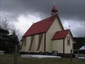 view gallery view galleryNE12.6 km |  St Pauls Anglican Church, Tokaanu. Southern Lake Taupo. New Zealand. St Pauls Anglican Church, Tokaanu. Southern Lake Taupo. New Zealand.
in Anglican and Episcopal Churches An historic church stands in the thermal Maori village of Tokaanu. It is the St Pauls Anglican Church. posted by: Punga and Paua location: North Island, New Zealand date approved: 08/05/2013 last visited: 11/23/2013 |
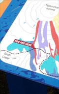 view gallery view galleryS12.6 km | 'You are here" on the Tongariro Corssing (New Zealand) in 'You Are Here' Maps A Sign that is along the Tongariro Alpine Crossing.
The sign is also used in a Earthcache called Ngaruhoe - Mt Doom GC24VXZ posted by: nzkeko location: North Island, New Zealand date approved: 02/18/2012 last visited: 03/08/2024 |
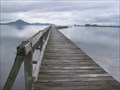 view gallery view galleryNE13.2 km |  Tokaanu Wharf. Lake Taupo. New Zealand. Tokaanu Wharf. Lake Taupo. New Zealand.
in Piers The Tokaanu Wharf on southern Lake Taupo dates from the early 1800's and is one of the oldest structures of its kind in New Zealand. posted by: Punga and Paua location: North Island, New Zealand date approved: 07/11/2009 last visited: 04/06/2011 |
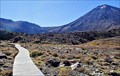
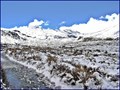 view gallery view galleryS13.2 km |  Mangatepopo Valley in winter, Tongariro National Park. North Island, New Zealand. Mangatepopo Valley in winter, Tongariro National Park. North Island, New Zealand.
in Scenic Overlooks Completely surrounded by the beautiful volcanic mountains in the Central North Island, this scenic winter overlook gives stunning 360 degree views from the walking track to the Mangatepopo Hut. posted by: Punga and Paua location: North Island, New Zealand date approved: 07/27/2020 last visited: 03/08/2024 |
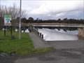 view gallery view galleryNE13.4 km |  Tokaanu South Boat Ramp. Lake Taupo. New Zealand. Tokaanu South Boat Ramp. Lake Taupo. New Zealand.
in Boat Ramps A sheltered boat ramp situated on the Southern shores of Lake Taupo at the Tokaanu Tailrace in Tokaanu Bay. posted by: Punga and Paua location: North Island, New Zealand date approved: 08/07/2013 last visited: 08/07/2013 |
|