 view gallery view gallery SW6.9 km SW6.9 km
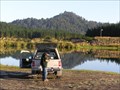
|   Lake Otamangakau. Central Plateau. New Zealand. Lake Otamangakau. Central Plateau. New Zealand.
in Fishing Holes Lake Otamangakau provides wilderness trout fishing on a lake to the south-west of Lake Taupo. Mostly rainbow (some to trophy sizes) but also many large brown trout.
posted by:  Punga and Paua Punga and Paua location: New Zealand date approved: 05/27/2008 last visited: 05/27/2008 |
 view gallery view gallery S8 km S8 km
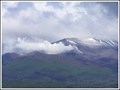
|  Te Maari Craters, Mt Tongariro. New Zealand. Te Maari Craters, Mt Tongariro. New Zealand.
in Volcano Watching After laying dormant for 115 years, Te Maari craters erupted in August and November of 2012 and are still billowing steam and gas from the vents, providing interesting viewing for volcano watchers. posted by: Punga and Paua location: North Island, New Zealand date approved: 01/25/2013 last visited: 01/29/2013 |
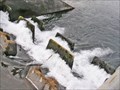 view gallery view gallerySW8.7 km |  Otamangakau Canals, Central Plateau. New Zealand. Otamangakau Canals, Central Plateau. New Zealand.
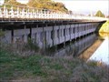
in Fish Ladders Fish steps link the different levels of the canals in the Lake Otamangakau area, part of the Tongariro Hydro Scheme. posted by: Punga and Paua location: North Island, New Zealand date approved: 10/16/2013 last visited: 10/16/2013 |
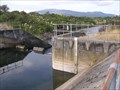 view gallery view gallerySW8.7 km |  Otamangakau Canal Gauge. Lake Otamangakau. New Zealand. Otamangakau Canal Gauge. Lake Otamangakau. New Zealand.
in River Gauges A water level gauge is situated above the concrete weir on the Otamangakau Canal near Lake Te Whaiau to measure water levels in the canal system. posted by: Punga and Paua location: North Island, New Zealand date approved: 04/03/2013 last visited: 04/03/2013 |
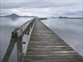 view gallery view gallery E9.7 km E9.7 km
|  Tokaanu Wharf. Lake Taupo. New Zealand. Tokaanu Wharf. Lake Taupo. New Zealand.
in Piers The Tokaanu Wharf on southern Lake Taupo dates from the early 1800's and is one of the oldest structures of its kind in New Zealand. posted by: Punga and Paua location: North Island, New Zealand date approved: 07/11/2009 last visited: 04/06/2011 |
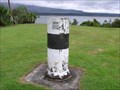 view gallery view gallery SE9.8 km SE9.8 km
|  Geodetic Survey Mark. Opotaka. Lake Rotoaira. New Zealand. Geodetic Survey Mark. Opotaka. Lake Rotoaira. New Zealand.
in Australia/NZ Benchmarks A cylindrical concrete Land Information New Zealand marker at the historic Opotaka maori village site beside Lake Rotoaira. posted by: Punga and Paua location: North Island, New Zealand date approved: 01/07/2010 last visited: 11/13/2010 |
 view gallery view gallery NE10 km NE10 km
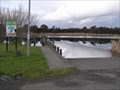
|  Pukawa Boat Ramp. Pukawa. Lake Taupo. New Zealand. Pukawa Boat Ramp. Pukawa. Lake Taupo. New Zealand.
in Boat Ramps A concrete boat ramp at Pukawa Bay on the south western shores of Lake Taupo. posted by: Punga and Paua location: North Island, New Zealand date approved: 07/16/2013 last visited: 07/16/2013 |
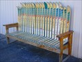 view gallery view galleryE10 km |  Après-Ski Rest. Tokaanu. North Is. New Zealand. Après-Ski Rest. Tokaanu. North Is. New Zealand.
in Artistic Seating An artistic imagination has produced a comfortable Après-Ski Rest outside the local Ski Hire Shop in Tokaanu Village. posted by: Punga and Paua location: North Island, New Zealand date approved: 06/03/2009 last visited: 04/06/2011 |
 view gallery view galleryE10.1 km |  Tokaanu Geothermal Boardwalk, Tokaanu. North Is. New Zealand. Tokaanu Geothermal Boardwalk, Tokaanu. North Is. New Zealand.
in Non-Coastal Boardwalks Enjoy a free boardwalk through a natural geothermal landscape of marshy swampland, clear waters in steaming hot bubbling pools and boiling mud in the village of Tokaanu. posted by: Punga and Paua location: North Island, New Zealand date approved: 04/08/2019 last visited: 04/08/2019 |
 view gallery view galleryNE10.1 km |  Yellow Beetle Lives Here. Mohi St, Omori. North Is. New Zealand. Yellow Beetle Lives Here. Mohi St, Omori. North Is. New Zealand.
in Garage Door Art A Yellow Beetle VW is parked on the garage door of an unusual home built into the ground on the hill above Omori. posted by: Punga and Paua location: North Island, New Zealand date approved: 05/09/2016 last visited: 05/12/2016 |
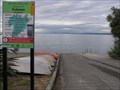
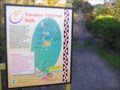 view gallery view galleryE10.1 km |  You Are Here at the Tokaanu Thermal Walkway. New Zealand. You Are Here at the Tokaanu Thermal Walkway. New Zealand.
in 'You Are Here' Maps YOU ARE HERE at the Tokaanu Thermal area, close to the resting place of a Taniwha. posted by: Punga and Paua location: North Island, New Zealand date approved: 09/09/2009 last visited: 03/03/2010 |
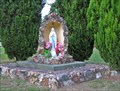 view gallery view galleryE10.1 km |  Virgin Mary in Tokaanu. Southern Lake Taupo. New Zealand. Virgin Mary in Tokaanu. Southern Lake Taupo. New Zealand.
in Statues of Religious Figures This beautiful little statue of Mary stands on the roadside in the village of Tokaanu in the Southern Lake Taupo district. posted by: Punga and Paua location: North Island, New Zealand date approved: 08/07/2013 last visited: 08/07/2013 |
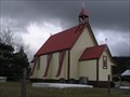 view gallery view galleryE10.1 km |  St Pauls Anglican Church, Tokaanu. Southern Lake Taupo. New Zealand. St Pauls Anglican Church, Tokaanu. Southern Lake Taupo. New Zealand.
in Anglican and Episcopal Churches An historic church stands in the thermal Maori village of Tokaanu. It is the St Pauls Anglican Church. posted by: Punga and Paua location: North Island, New Zealand date approved: 08/05/2013 last visited: 11/23/2013 |
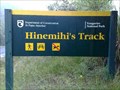 view gallery view gallerySE10.3 km |  Hinemihi's Track. Mt Pihanga. New Zealand. Hinemihi's Track. Mt Pihanga. New Zealand.
in Ancient Traces and Roads Hinemihi's Track on Te Ponanga Saddle near Mt Pihanga was part of an early Pre-European Maori trail across the Central Plateau from Wanganui to Taupo. posted by: Punga and Paua location: North Island, New Zealand date approved: 09/04/2009 last visited: 11/13/2010 |
 view gallery view galleryE10.5 km | Tokaanu South Boat Ramp. Lake Taupo. New Zealand. in Boat Ramps A sheltered boat ramp situated on the Southern shores of Lake Taupo at the Tokaanu Tailrace in Tokaanu Bay. posted by: Punga and Paua location: North Island, New Zealand date approved: 08/07/2013 last visited: 08/07/2013 |
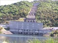 view gallery view galleryE10.8 km |  Tokaanu Hydroelectric Power Station. Tokaanu. North Is. New Zealand. Tokaanu Hydroelectric Power Station. Tokaanu. North Is. New Zealand.
in Hydroelectric Power Stations The Tokaanu Power Station, part of the Tongariro Hydro Power Scheme, is a 240 MW capacity station situated on the base of Mount Tihia at the southern end of Lake Taupo. posted by: Punga and Paua location: North Island, New Zealand date approved: 01/25/2013 last visited: 01/26/2013 |
 view gallery view galleryNE10.8 km | Kuratau Hydro Power Station. Omori. North Is. New Zealand. in Hydroelectric Power Stations A small hydro power station in the Western Lake Taupo area, situated at the end of Kuratau Hydro Rd, Omori. posted by: Punga and Paua location: North Island, New Zealand date approved: 02/17/2013 last visited: 02/17/2013 |
 view gallery view galleryNE10.8 km | Kuratau River Gauge, Omori. New Zealand. in River Gauges A couple of river gauges stand in the stream below the Kuratau Hydro Power House. posted by: Punga and Paua location: North Island, New Zealand date approved: 02/17/2013 last visited: 02/17/2013 |
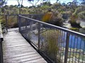
 view gallery view galleryE11.3 km |  Trout Bridge. Tokaanu. North Is. New Zealand. Trout Bridge. Tokaanu. North Is. New Zealand.
in Man-made Animal Bridges and Crossings A unique aquaduct in Tokaanu, specifically designed to carry the Tokaanu Stream with all its aquatic life and spawning trout. posted by: Punga and Paua location: North Island, New Zealand date approved: 08/30/2018 last visited: 08/30/2018 |
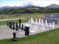 view gallery view galleryNE11.4 km |  Chess and Draughts Board, Kuratau. Lake Taupo. New Zealand. Chess and Draughts Board, Kuratau. Lake Taupo. New Zealand.
in Giant Board Games In the lakeside holiday village of Kuratau there is an ideal spot for a relaxing game of chess or draughts in the large grassy park and playground. posted by: Punga and Paua location: North Island, New Zealand date approved: 03/01/2017 last visited: 03/01/2017 |
 view gallery view galleryE11.9 km |  Go Fishing and Catch a Fish. Go Fishing and Catch a Fish.
in Photo Goals It's time to get your fishing gear out. Your goal is to go fishing and catch a fish and have your photo taken. If you're quick enough you can still catch, photograph and release. posted by: Punga and Paua location: North Island, New Zealand date approved: 07/04/2021 last visited: 07/03/2023 |
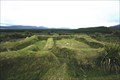 view gallery view gallerySW12.1 km |  Te Porere Redoubt. Central Plateau. North Is. New Zealand. Te Porere Redoubt. Central Plateau. North Is. New Zealand.
in Maori Historic Sites Te Porere contains the earthworks of a Maori fortification built by the prophet and warrior Te Kooti and is the site of the last major engagement of the New Zealand Wars in October 1869. posted by: Punga and Paua location: North Island, New Zealand date approved: 11/23/2008 last visited: 11/23/2008 |
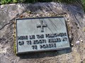 view gallery view gallerySW12.1 km |  Battle of Te Porere. Central Plateau. New Zealand. Battle of Te Porere. Central Plateau. New Zealand.
in Battlefields The redoubts at Te Porere contain the earthworks of a Maori fortification built by the prophet and warrior Te Kooti and is the site of the last major engagement of the New Zealand Wars on 4th October 1869. posted by: Punga and Paua location: North Island, New Zealand date approved: 03/08/2010 last visited: 03/08/2010 |
 view gallery view galleryNE12.2 km | Kuratau Boat Ramp. Kuratau. Lake Taupo. New Zealand. in Boat Ramps A concrete boat ramp with adjacent jetty situated at the popular holiday village of Kuratau on the south western shores of Lake Taupo. posted by: Punga and Paua location: North Island, New Zealand date approved: 07/16/2013 last visited: 07/16/2013 |
 view gallery view galleryE13.8 km |  S38 58.06 E175 48.49 - Turangi Aero Club. Turangi. New Zealand. S38 58.06 E175 48.49 - Turangi Aero Club. Turangi. New Zealand.
in Permanent Geographic Coordinates The Turangi Aero Club sign outside the Ted Phillips Airfield in Turangi, shows a set of geographic co-ordinates for the airfield. posted by: Punga and Paua location: North Island, New Zealand date approved: 08/07/2011 last visited: 08/07/2011 |
|