 view gallery view gallery E0 km E0 km
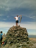
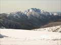
|   Mount Bogong Mount Bogong
in Mountain Summits Head to the summit of Mount Bogong the highest mountain in Victoria. posted by:  379Jonti379 379Jonti379 location: Victoria, Australia date approved: 05/27/2009 last visited: 11/25/2018 |
 view gallery view gallery NW4.7 km NW4.7 km
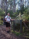
|  Staircase Spur Staircase Spur
in Hiking and walking trailheads The Staircase Spur is a 6km track that leads to the summit of Mount Bogong the highest mountain in Victoria 1986m. posted by: 379Jonti379 location: Victoria, Australia date approved: 06/14/2009 last visited: never |
 view gallery view gallery W12.2 km W12.2 km
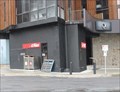
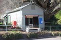
|  Mount Beauty LPO, Vic, 3699 Mount Beauty LPO, Vic, 3699
in Australia Post Offices An LPO in a town at the foot of the snowfields posted by: blingg location: Victoria, Australia date approved: 07/28/2018 last visited: never |
 view gallery view galleryW13 km | Tawonga South LPO, Vic, 3698 in Australia Post Offices An LPO in the Kiewa Valley posted by: blingg location: Victoria, Australia date approved: 07/28/2018 last visited: never |
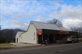
 view gallery view gallery S14.6 km S14.6 km
| Falls Creek LPO, Vic, 3699 in Australia Post Offices One of the highest elevation post offices in Victoria posted by: blingg location: Victoria, Australia date approved: 10/20/2019 last visited: never |
 view gallery view galleryS15.1 km |  Falls Creek Falls Creek
in Winter Sports Locations Falls creek is a ski resort located in the Victorian Alps. posted by: 379Jonti379 location: Victoria, Australia date approved: 05/30/2009 last visited: 12/17/2015 |
 view gallery view galleryW15.4 km | Tawonga LPO, Vic, 3697 in Australia Post Offices A Kiewa Valley LPO posted by: blingg location: Victoria, Australia date approved: 07/28/2018 last visited: never |
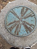 view gallery view galleryW16.7 km |  Tawonga Gap Orientation table - Australia Tawonga Gap Orientation table - Australia
in Orientation Tables Tawonga Gap Orientation table
Elevation 891 m posted by: 2 Leg Drive location: Victoria, Australia date approved: 02/02/2024 last visited: never |
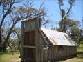 view gallery view galleryS18.2 km |  Wallace Hut - Alpine National Park - Victoria Wallace Hut - Alpine National Park - Victoria
in Remote Backcountry Shelters Built in 1889 by the Wallace brothers (Arthur, William and Stewart), this hut is one of the oldest mountain huts in the Alpine National Park. posted by: bucketeer location: Victoria, Australia date approved: 04/19/2017 last visited: never |
 view gallery view gallery SW23.3 km SW23.3 km
| Mount Feathertop in Mountain Summits Head to the summit of Mount Feathertop 1922 meters above sea level. Making it the 2nd highest mountain in Victoria!!! Its summit can be seen from all high points in the great dividing range and it is easy to recignize due to its unusual shaped peak. posted by: 379Jonti379 location: Victoria, Australia date approved: 05/27/2009 last visited: 06/25/2019 |
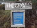 view gallery view galleryW24.5 km |  'The Graves' - Freeburgh Cemetery - Harrietville, Vic, Australia 'The Graves' - Freeburgh Cemetery - Harrietville, Vic, Australia
in Abandoned Cemeteries On the Great Alpine Road, between Freeburgh and Harrietville are a few graves up a forested hillside. posted by: Grahame Cookie location: Victoria, Australia date approved: 11/06/2017 last visited: never |
 view gallery view gallerySW24.8 km | Federation Hut in Remote Backcountry Shelters Federation Hut is the main shelter on Mount Feathertop. posted by: 379Jonti379 location: Victoria, Australia date approved: 06/17/2009 last visited: 06/27/2019 |
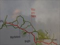 view gallery view galleryW25.7 km |  Pathways to Summit - You Are Here - 'Bright', Vic, Australia Pathways to Summit - You Are Here - 'Bright', Vic, Australia
in 'You Are Here' Maps On the Great Alpine Road, in north eastern Victoria is this Lookout, with a sign, that shows where You Are on your journey. posted by: Grahame Cookie location: Victoria, Australia date approved: 11/22/2017 last visited: never |
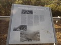 view gallery view galleryW25.7 km |  Pathways to the Summit - 'Bright', Victoria Pathways to the Summit - 'Bright', Victoria
in Australian Historical Markers This interpretative sign on the Great Alpine Road is about 5 kms south east of the town of Bright, in the lower Victorian Alps. posted by: Grahame Cookie location: Victoria, Australia date approved: 11/22/2017 last visited: never |
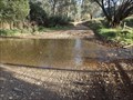 view gallery view galleryW26.4 km |  Back Germantown Rd - German Ck, Bright, Victoria, Australia Back Germantown Rd - German Ck, Bright, Victoria, Australia
in Bridgeless Water Crossings A gravel Back Germantown Road leads to this Bridgeless Crossing of German Creek. posted by: Grahame Cookie location: Victoria, Australia date approved: 11/05/2017 last visited: never |
 view gallery view gallerySW27.8 km | Harrietville CPA, Vic, 3741 in Australia Post Offices A CPA in the Victorian Alps foothills posted by: blingg location: Victoria, Australia date approved: 07/23/2018 last visited: never |
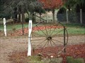 view gallery view galleryW28.5 km |  Wet Gully Track, Wagon Wheels - Bright, Victoria, Australia Wet Gully Track, Wagon Wheels - Bright, Victoria, Australia
in Wagon Wheels A pair of 'buggy' iron wheels at the entrance to this property posted by: Grahame Cookie location: Victoria, Australia date approved: 11/10/2017 last visited: never |
 view gallery view galleryW29.1 km | Wandiligong CPA, Vic, 3744 in Australia Post Offices A CPA in an old gold mining town posted by: blingg location: Victoria, Australia date approved: 07/23/2018 last visited: never |
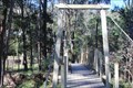 view gallery view galleryW29.3 km |  The Diggings Swing Bridge - Wandiligong, Vic, Australia The Diggings Swing Bridge - Wandiligong, Vic, Australia
in Pedestrian Suspension Bridges A swing bridge over Morses Creek posted by: blingg location: Victoria, Australia date approved: 10/15/2019 last visited: never |
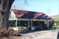
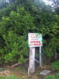 view gallery view galleryW29.5 km |  Wandiligong Maze and Cafe - Wandiligong, Victoria, Australia Wandiligong Maze and Cafe - Wandiligong, Victoria, Australia
in Outdoor Mazes The Wandi Maze is claimed to be the largest living hedge maze in Australia with over 2km's of pathways. posted by: themd location: Victoria, Australia date approved: 01/04/2012 last visited: 05/18/2016 |
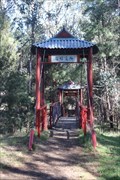 view gallery view galleryW29.5 km | Chinese swing bridge - Wandiligong, Vic, Australia in Pedestrian Suspension Bridges A swing bridge in the Chinese style posted by: blingg location: Victoria, Australia date approved: 10/15/2019 last visited: never |
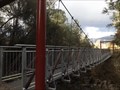 view gallery view galleryW29.8 km | Ovens River - Bright, Victoria, Australia in Pedestrian Suspension Bridges A new looking Suspension Bridge over Ovens River near Bright, in north eastern Victoria. posted by: Grahame Cookie location: Victoria, Australia date approved: 11/06/2017 last visited: 10/13/2019 |
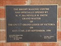 view gallery view galleryW30.1 km |  Lodge of Unity, No. 54 - Bright, Victoria, Australia Lodge of Unity, No. 54 - Bright, Victoria, Australia
in Grand Opening The Bright Masonic Centre, was officially Opened by M.W. Bro. Neville B. Smith G.M. on 21st September, 1996 posted by: Grahame Cookie location: Victoria, Australia date approved: 11/20/2017 last visited: never |
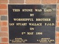 view gallery view galleryW30.1 km |  Lodge of Unity - 1996 - Bright, Victoria, Australia Lodge of Unity - 1996 - Bright, Victoria, Australia
in Dated Buildings and Cornerstones The black marble Foundation Stone is in the red/orange brick building of the Masonic Lodge in Hawthorn Lane, Bright, for 5th May, 1996. posted by: Grahame Cookie location: Victoria, Australia date approved: 11/19/2017 last visited: never |
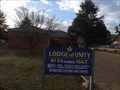 view gallery view galleryW30.1 km |  Lodge of Unity No. 54 - Bright, Victoria, Australia Lodge of Unity No. 54 - Bright, Victoria, Australia
in Masonic Temples The Bright Masonic Centre is in Hawthorn Lane, and meets on the third Tuesday of the month. posted by: Grahame Cookie location: Victoria, Australia date approved: 11/19/2017 last visited: never |
|