 view gallery view gallery E31.7 km E31.7 km
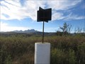
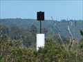
|   LEEUWENBOSCH 3424-99 LEEUWENBOSCH 3424-99
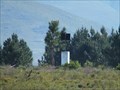
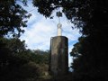
in Southern African Trig Beacons This is a roadside beacon alongside the N2 highway, a few kms west of Humansdorp. posted by:  Fish Eagle Fish Eagle location: Eastern Cape, South Africa date approved: 11/03/2019 last visited: never |
 view gallery view gallery W32.5 km W32.5 km
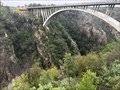
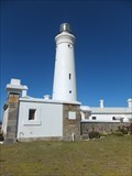
|  Paul Sauer Bridge - Eastern Cape, ZA Paul Sauer Bridge - Eastern Cape, ZA
in Arch Bridges Concrete arch bridge over the Storms River Gorge in Tsitsikamma NP, Eastern Cape. posted by: André de Montbard location: Eastern Cape, South Africa date approved: 11/27/2019 last visited: never |
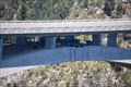
 view gallery view galleryW35.9 km |  The Garden Route - Storms River Mouth Suspension Bridge - Tsitsikamma National Park - Storms River, South Africa The Garden Route - Storms River Mouth Suspension Bridge - Tsitsikamma National Park - Storms River, South Africa
in National Scenic Byways Storms River mouth is spanned by a pedestrian suspension bridge, offering great views over the gorge on one side and the Indian Ocean on the other side. It is a popular tourist attraction. posted by:  denben denben location: Eastern Cape, South Africa date approved: 11/27/2013 last visited: 11/13/2019 |
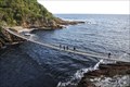 view gallery view galleryW35.9 km |  Storms River Mouth Suspension Bridge - Tsitsikamma National Park - Storms River, South Africa Storms River Mouth Suspension Bridge - Tsitsikamma National Park - Storms River, South Africa
in Pedestrian Suspension Bridges Storms River mouth is spanned by a pedestrian suspension bridge, offering great views over the gorge on one side and the Indian Ocean on the other side. It is a popular tourist attraction. posted by: denben location: Eastern Cape, South Africa date approved: 11/27/2013 last visited: 11/13/2019 |
 view gallery view galleryW35.9 km |  Storms River Mouth Suspension Bridge - Tsitsikamma National Park - Storms River, South Africa Storms River Mouth Suspension Bridge - Tsitsikamma National Park - Storms River, South Africa
in Official Local Tourism Attractions Storms River mouth is spanned by a pedestrian suspension bridge, offering great views over the gorge on one side and the Indian Ocean on the other side. It is a popular tourist attraction. posted by: denben location: Eastern Cape, South Africa date approved: 11/26/2013 last visited: 11/13/2019 |
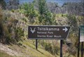 view gallery view galleryW36.4 km |  Tsitsikamma National Park Tsitsikamma National Park
in National Parks of the World Tsitsikamma National Park is located in an area called the Garden Route, the Southern Cape of South Africa. The Park has 80 km of rocky coastline and incorporates a remote mountainous region. posted by: Windsocker location: Eastern Cape, South Africa date approved: 03/05/2008 last visited: 11/13/2019 |
![Image for Mouth Trail - Tsitsikamma National Park - Storms River, South Africa [edit]](https://img.geocaching.com/waymarking/small/af63ce77-dea5-42a8-89f6-10f5db5e3ac6.JPG) view gallery view galleryW36.5 km |  Mouth Trail - Tsitsikamma National Park - Storms River, South Africa [edit] Mouth Trail - Tsitsikamma National Park - Storms River, South Africa [edit]
in Hiking and walking trailheads The Mouth trail to get to the picturesque Storms River Mouth Suspension Bridge is one of the shortest hikes of this part of the Tsitsikamma National park. The trail starts near the Park's Restaurant. posted by: denben location: Eastern Cape, South Africa date approved: 11/28/2013 last visited: 11/26/2019 |
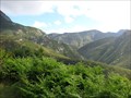 view gallery view galleryW36.5 km |  The Garden Route - Eastern Cape, South Africa The Garden Route - Eastern Cape, South Africa
in 1000 Places to See Before You Die The Garden Route stretches from Port Elizabeth (the Eastern Cape) to the Mossel Bay (the Western Cape), or vice versa. The name comes from the verdant and diverse vegetation encountered and the numerous lagoons and lakes dotted along the coast. posted by: denben location: Eastern Cape, South Africa date approved: 12/08/2013 last visited: 11/13/2019 |
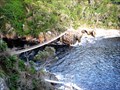
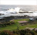 view gallery view galleryW36.5 km |  Storms River Mouth Rest Camp - Tsitsikamma National Park, South Africa Storms River Mouth Rest Camp - Tsitsikamma National Park, South Africa
in Wavy Places We witnessed these impressive waves while visiting the Tsitsikamma National Park on the Garden Route in South Africa. The Indian Ocean breakers, pounding rocky shores is one of Tsitsikamma’s spectacular sceneries. posted by: denben location: Eastern Cape, South Africa date approved: 11/21/2013 last visited: 11/13/2019 |
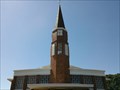
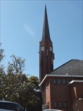 view gallery view galleryE45.7 km | DRC HUMANSDORP 3424-293 in Southern African Trig Beacons The beacon is the top of the spire of the Dutch Reformed Church in Humansdorp. posted by: Fish Eagle location: Eastern Cape, South Africa date approved: 11/03/2019 last visited: never |
 view gallery view gallery NE50.5 km NE50.5 km
| KWAGGA DRC 3324-287 in Southern African Trig Beacons This beacon is next to the R331 just outside Patensie. posted by: Spesbona location: Eastern Cape, South Africa date approved: 07/05/2015 last visited: never |
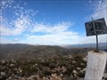
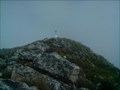 view gallery view galleryW54.4 km | KRAKEEL RIVIER NEW 3323-238 in Southern African Trig Beacons This beacon is on Formosa Peak. You should not have a fear of heights and be fairly fit to reach this one in 3 to 4 hours. posted by: Spesbona location: Western Cape, South Africa date approved: 07/10/2015 last visited: never |
 view gallery view galleryW54.4 km | Krakeel Rivier New in Southern African Trig Beacons This peak shoould be on everyones bucket list of mountains to climb posted by: roadrunred location: Western Cape, South Africa date approved: 10/11/2019 last visited: 10/04/2020 |
 view gallery view gallery SE55.2 km SE55.2 km
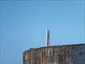
| RESIG 3424-312 in Southern African Trig Beacons This is a standard beacon on top of a reservoir in St Francis Bay. posted by: Fish Eagle location: Eastern Cape, South Africa date approved: 11/03/2019 last visited: never |
 view gallery view galleryNE55.8 km | KRAAIBOSCH 3324-44 in Southern African Trig Beacons This beacon is next to the Elands River Road just outside Patensie. posted by: Spesbona location: Eastern Cape, South Africa date approved: 07/05/2015 last visited: never |
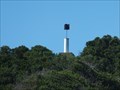
 view gallery view gallerySE58.7 km | CAPE ST FRANCIS LT H 3424-90 in Southern African Trig Beacons The beacon is the top of the light of the Cape St Francis Lighthouse. posted by: Fish Eagle location: Eastern Cape, South Africa date approved: 11/03/2019 last visited: never |
 view gallery view galleryW58.7 km |  Bloukrans Bungee Jump - Bloukransbridge South Africa Bloukrans Bungee Jump - Bloukransbridge South Africa
in Bungee Jump Sites Bungee jumping in South Africa has earned a global reputation for its claim to having the highest commercial bungee jump in the world. posted by: Windsocker location: Eastern Cape, South Africa date approved: 02/29/2008 last visited: 11/13/2019 |
 view gallery view galleryW58.9 km | Bloukrans Bridge - Western Cape, ZA in Arch Bridges Bloukrans Bridge over Bloukransrivier in Tsitsikamma Area, Western Cape. posted by: André de Montbard location: Western Cape, South Africa date approved: 11/27/2019 last visited: never |
 view gallery view gallerySE59.2 km | ST FRANCISPUNT 3424-306 in Southern African Trig Beacons This beacon is on top of a dune near Cape St Francis. posted by: Fish Eagle location: Eastern Cape, South Africa date approved: 11/03/2019 last visited: never |
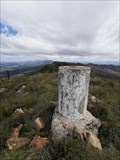
 view gallery view galleryNE62.6 km | Cockscomb 3324-9 in Southern African Trig Beacons A challenging climd completed in a day posted by: roadrunred location: Eastern Cape, South Africa date approved: 10/11/2019 last visited: never |
 view gallery view galleryE85.9 km | OUTSPAN 3325-297 in Southern African Trig Beacons This beacon is in the Van Stadens Wildflower Reserve and can viewed from the N2 highway, or visited by entering the reserve. posted by: Fish Eagle location: Eastern Cape, South Africa date approved: 11/03/2019 last visited: never |
 view gallery view gallery NW88.8 km NW88.8 km
| BLAAUWKOP 3323-5 in Southern African Trig Beacons Situated on top of Blaauwkop in the Blue Hills Nature Reserve posted by: roadrunred location: Western Cape, South Africa date approved: 03/25/2019 last visited: never |
 view gallery view galleryNE91.6 km | Strijdomsberg 3325-186 in Southern African Trig Beacons Tough but of historical interest. posted by: roadrunred location: Eastern Cape, South Africa date approved: 11/26/2020 last visited: never |
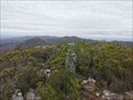 view gallery view galleryNE93.3 km | Strydomskop 3325-369 in Southern African Trig Beacons The lower peak but the more pleasant trail posted by: roadrunred location: Eastern Cape, South Africa date approved: 11/26/2020 last visited: never |
 view gallery view galleryE97.4 km | ISLAND 3325-290 in Southern African Trig Beacons This beacon is located in The Island Nature Reserve just outside Port Elizabeth. Depending on fitness levels it might take 5 hours or longer. posted by: Spesbona location: Eastern Cape, South Africa date approved: 07/05/2015 last visited: never |
|