 view gallery view gallery NE4.2 km NE4.2 km
|   Mooney Mooney Creek (Creek Below), NSW, Australia Mooney Mooney Creek (Creek Below), NSW, Australia
in Scenic Overlooks Mooney Mooney Creek (Creek Below), NSW, Australia posted by:  Pensive Travellers Pensive Travellers location: New South Wales, Australia date approved: 08/05/2008 last visited: 09/30/2016 |
 view gallery view gallery SE4.8 km SE4.8 km
|  Mooney Mooney Boat Ramp, NSW, Australia Mooney Mooney Boat Ramp, NSW, Australia
in Boat Ramps This is a very busy boat ramp, as it is more accessible than heading into Brooklyn. posted by:  Grahame Cookie Grahame Cookie location: New South Wales, Australia date approved: 10/09/2017 last visited: never |
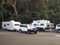 view gallery view gallerySE4.8 km |  Hawkesbury River Rest Area - Mooney Mooney, NSW, Australia Hawkesbury River Rest Area - Mooney Mooney, NSW, Australia
in Free Overnight RV Parking Locations With good access, while heading south or north on the Pacific Motorway, this is a good place to pull your van over. posted by: Grahame Cookie location: New South Wales, Australia date approved: 03/09/2018 last visited: never |
 view gallery view gallerySE5 km |  F3 Freeway, Mooney Mooney, NSW, Australia F3 Freeway, Mooney Mooney, NSW, Australia
in Web Cameras F3 Freeway Traffic Camera, Mooney Mooney, NSW, Australia posted by: Pensive Travellers location: New South Wales, Australia date approved: 06/25/2008 last visited: 03/08/2017 |
 view gallery view gallerySE5.3 km |  Hawkesbury River Bridge, Mooney, NSW, Australia Hawkesbury River Bridge, Mooney, NSW, Australia
in Truss Bridges Hawkesbury River Bridge, Mooney, NSW, Australia. posted by: Pensive Travellers location: New South Wales, Australia date approved: 06/21/2008 last visited: 02/16/2016 |
 view gallery view gallery N6.4 km N6.4 km
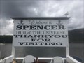
|  Hub of the Universe - Spencer, NSW Australia Hub of the Universe - Spencer, NSW Australia
in Welcome Signs Visit Spencer 'Hub of the Universe'! :D posted by: Nyssaflutterby location: New South Wales, Australia date approved: 04/02/2024 last visited: never |
 view gallery view gallery E7.4 km E7.4 km
|  Hawkesbury River Rail Bridge, Mooney, NSW, Australia Hawkesbury River Rail Bridge, Mooney, NSW, Australia
in Railroad Bridges Hawkesbury River Rail Bridge, Mooney, NSW, Australia posted by: Pensive Travellers location: New South Wales, Australia date approved: 07/07/2008 last visited: 03/02/2015 |
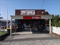
 view gallery view gallerySE7.6 km |  Pie in the Sky, Cowan, NSW, Australia Pie in the Sky, Cowan, NSW, Australia
in Independent Coffee Shops Pie in the Sky, Cowan, NSW, Australia posted by: Pensive Travellers location: New South Wales, Australia date approved: 12/22/2008 last visited: 07/31/2016 |
 view gallery view gallerySE7.6 km |  Pie in the Sky, Cowan, NSW, Australia Pie in the Sky, Cowan, NSW, Australia
in Independent Bakeries Pie in the Sky, Cowan, NSW, Australia posted by: Pensive Travellers location: New South Wales, Australia date approved: 12/21/2008 last visited: 07/31/2016 |
 view gallery view gallerySE7.6 km |  Pie in the Sky, Cowan, NSW, Australia Pie in the Sky, Cowan, NSW, Australia
in Landlocked Boats Pie in the Sky, Cowan, NSW, Australia posted by: Pensive Travellers location: New South Wales, Australia date approved: 01/25/2009 last visited: 07/31/2016 |
 view gallery view gallery S9.8 km S9.8 km
|  Great North Walk - Berowra, NSW, Australia Great North Walk - Berowra, NSW, Australia
in Long Distance Hiking Trails While the local track is called the Benowie Track, it is a part of the Great North Walk, from Circular Quay, in Sydney, to Newcastle, with this entry point at Berowra Waters. posted by: Grahame Cookie location: New South Wales, Australia date approved: 01/15/2018 last visited: never |
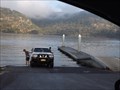
 view gallery view galleryS9.8 km |  Berowra Waters Ferry, NSW. Australia. Berowra Waters Ferry, NSW. Australia.
in Ferries and Ferry Landings The Berowra Waters Ferry is a cable ferry across the Berowra Creek, a tributary of the Hawkesbury River. posted by: Punga and Paua location: New South Wales, Australia date approved: 02/01/2013 last visited: 03/11/2017 |
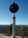
 view gallery view gallery NW10.5 km NW10.5 km
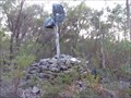
|  Gunderman TP, Canoelands, NSW Gunderman TP, Canoelands, NSW
in Australian Trig Points Gunderman trig point is at GR1868 9420 on the 1st ed. Gunderman, 1:25,000 map (being in AusGeo66 UTM). It is a moderate sized cairn of rocks with a wooden pole and some vanes still trying to hang on.
Official Code: TS2366 posted by: Grahame Cookie location: New South Wales, Australia date approved: 12/07/2014 last visited: never |
 view gallery view galleryS11.4 km | Barnetts Road Reserve in Scenic Overlooks Looks out over the Berowra regional park, includes good water views. posted by: GO Team K. location: New South Wales, Australia date approved: 06/23/2007 last visited: 12/04/2016 |
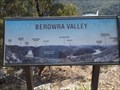 view gallery view galleryS11.4 km |  Berowra Valley - Berowra, NSW, Australia Berowra Valley - Berowra, NSW, Australia
in Orientation Tables At the Barnetts Road Reserve section of the Berowra Valley National Park is a Lookout, with a great view of the Berowra Valley. There is an Orientation Table to show various localities. posted by: Grahame Cookie location: New South Wales, Australia date approved: 01/14/2018 last visited: never |
 view gallery view galleryS11.4 km |  Barnetts Reserve, Berowra, NSW, Australia Barnetts Reserve, Berowra, NSW, Australia
in Public Playgrounds Almost overlooking the Berowra Valley National Park, this modest sized Playground will keep the 'littlies' occupied. posted by: Grahame Cookie location: New South Wales, Australia date approved: 01/15/2018 last visited: never |
 view gallery view galleryE11.7 km | Wondabyne Trig, Wondabyne, NSW in Australian Trig Points Great North Walk between Patonga and Wondabyne. Great views of Woy Woy peninsula and Brisbane Water National Park. posted by: thebream location: New South Wales, Australia date approved: 06/21/2010 last visited: 10/06/2013 |
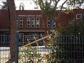 view gallery view galleryS11.7 km |  Berowra Baptist Church - Berowra, NSW, Australia Berowra Baptist Church - Berowra, NSW, Australia
in Baptist Churches This brick building in Berowra, on the way to Berowra Waters, looks like it is a school. posted by: Grahame Cookie location: New South Wales, Australia date approved: 01/14/2018 last visited: never |
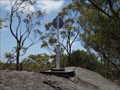 view gallery view galleryNE11.7 km | Freeway T.S., Australia Walkabout Wildlife Park, Calga, NSW in Australian Trig Points Not far from what is now called the Pacific Motorway, is this steel pillar with mast, vanes, and name plate. * There is COST for entry *
Official Code: TS10636 posted by: Grahame Cookie location: New South Wales, Australia date approved: 11/02/2016 last visited: never |
 view gallery view galleryS12.1 km |  Berowra LPO, NSW - 2081 Berowra LPO, NSW - 2081
in Australia Post Offices A 'boxy' red-brick building on Berowra Waters Road, very close to the Pacific Highway posted by: Grahame Cookie location: New South Wales, Australia date approved: 01/14/2018 last visited: never |
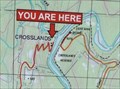 view gallery view galleryS13.2 km |  UR Here - Crosslands Youth and Convention Centre, NSW, Australia UR Here - Crosslands Youth and Convention Centre, NSW, Australia
in 'You Are Here' Maps On the western side of Berowra Creek is the privately owned Crosslands Youth and Convention Centre. The map shows the lay of the land for the Berowra Valley.
You could park your car at the boom gate, and walk on down to take a photo of the map. posted by: Grahame Cookie location: New South Wales, Australia date approved: 01/29/2016 last visited: never |
 view gallery view galleryNE13.2 km |  HIGHEST - Road Bridge in Australia HIGHEST - Road Bridge in Australia
in Superlatives The Mooney Mooney Creek Bridge is the highest road bridge in Australia at 75 meters high. posted by: Queens Blessing location: New South Wales, Australia date approved: 11/29/2009 last visited: 10/03/2017 |
 view gallery view galleryE13.2 km |  Warrah Trig - Patonga, NSW, Australia Warrah Trig - Patonga, NSW, Australia
in Scenic Roadside Look-Outs Another scenic Roadside Lookout on the Central Coast of NSW. posted by: Grahame Cookie location: New South Wales, Australia date approved: 04/08/2024 last visited: never |
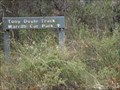 view gallery view galleryE13.2 km |  Tony Doyle Track - Patonga, NSW, Australia Tony Doyle Track - Patonga, NSW, Australia
in Hiking and walking trailheads This dirt track is maintained, but rather rough, and it has great views of Broken Bay. posted by: Grahame Cookie location: New South Wales, Australia date approved: 04/04/2024 last visited: never |
 view gallery view galleryE13.4 km | Warrah, Patonga, NSW in Australian Trig Points Warrah is located in the Brisbane Waters NP near Patonga, NSW. posted by: fathrtime location: New South Wales, Australia date approved: 08/25/2011 last visited: 01/01/2017 |
|