 view gallery view gallery SE0 km SE0 km
|   Crowdy Head Lighthouse, Crowdy Head, NSW Crowdy Head Lighthouse, Crowdy Head, NSW
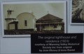
in Photos Then and Now This lighthouse was built in 1879, with the residence for the lighthouse keeper beside it (foundations are still there). The photo is from 1924. posted by:  Grahame Cookie Grahame Cookie location: New South Wales, Australia date approved: 10/21/2016 last visited: 05/05/2021 |
 view gallery view gallery W0 km W0 km
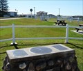
|  Crowdy Trig, Crowdy Head, NSW Crowdy Trig, Crowdy Head, NSW
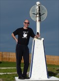
in Australian Trig Points Crowdy Trig station and lighthouse. Road access, car parking and picnic tables nearby. posted by: norkmeister location: New South Wales, Australia date approved: 08/13/2009 last visited: 05/29/2023 |
 view gallery view gallery N0.2 km N0.2 km
| Crowdy Head Lighthouse, Crowdy Head, NSW in Australian Trig Points Right beside the Crowdy (Head) concrete pedestal trig is the Lighthouse which is designated as a passive trig point, or at least the lightning rod / pinnacle above the 'light turret'. Official Code: TS10203; Official Name: Crowdy Head Lighthouse. posted by: Grahame Cookie location: New South Wales, Australia date approved: 01/11/2016 last visited: 05/29/2023 |
 view gallery view galleryN0.2 km |  Crowdy Head, NSW, Australia Crowdy Head, NSW, Australia
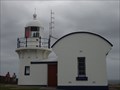
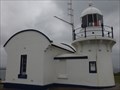
in Coastal Lighthouses Built in 1879, and originally manned by one lighthouse keeper, this lighthouse has a range that reaches out to 16 nautical miles. While its' height is 7 m, it stands with an elevation of 62 metres above sea level. posted by: Grahame Cookie location: New South Wales, Australia date approved: 01/05/2016 last visited: 05/30/2023 |
 view gallery view gallery NW0.6 km NW0.6 km
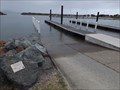
|  Crowdy Head, NSW, Australia Crowdy Head, NSW, Australia
in Boat Ramps On the sheltered side of Crowdy Head bay is the dual lane, concrete surfaced boat ramp. posted by: Grahame Cookie location: New South Wales, Australia date approved: 01/03/2016 last visited: never |
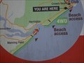 view gallery view galleryW1.6 km |  Harrington 'Beach Access' - You are here - Crowdy Head, NSW Harrington 'Beach Access' - You are here - Crowdy Head, NSW
in 'You Are Here' Maps At the 'Beach Rules' sign, on Crowdy Head Road, is a diagram showing where You Are. posted by: Grahame Cookie location: New South Wales, Australia date approved: 02/20/2018 last visited: never |
 view gallery view gallery SW6.6 km SW6.6 km
| Harrington Trig, Harrington, NSW in Australian Trig Points A nice headland trig point on a carin of stones. Also the location for a geocache. posted by: norkmeister location: New South Wales, Australia date approved: 08/13/2009 last visited: 05/29/2023 |
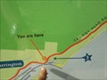 view gallery view gallerySW6.8 km | Pilot Hill URHere, Harrington, NSW, Australia in 'You Are Here' Maps Right on top of 'Pilot Hill' at Harrington, is an information board, with the Maritime History, on one side, and the Natural Attractions on the other side. This also shows where you are! If in doubt, there is a trig, and a geocache NEAR by. posted by: Grahame Cookie location: New South Wales, Australia date approved: 01/22/2016 last visited: never |
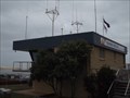 view gallery view gallerySW6.8 km |  Marine Rescue, Harrington, NSW, Australia Marine Rescue, Harrington, NSW, Australia
in Lifeboats and Rescue Stations Beside the breakwall on the Manning River entrance is the Harrington Marine Rescue unit. posted by: Grahame Cookie location: New South Wales, Australia date approved: 10/20/2016 last visited: never |
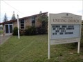
 view gallery view gallerySW6.8 km |  Our Lady, Star of the Sea - Catholic Church, Harrington, NSW, Australia Our Lady, Star of the Sea - Catholic Church, Harrington, NSW, Australia
in Roman Catholic Churches This wood-clad building is the Catholic Church for the community of Harrington and Crowdy Head. posted by: Grahame Cookie location: New South Wales, Australia date approved: 04/06/2024 last visited: never |
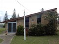
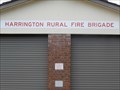 view gallery view gallerySW6.8 km |  Harrington Rural Fire Brigade Harrington Rural Fire Brigade
in Firehouses This small brick building is the Firehouse for the volunteer fire fighters of Harrington and Crowdy Head. posted by: Grahame Cookie location: New South Wales, Australia date approved: 04/07/2024 last visited: never |
 view gallery view gallerySW6.8 km |  Harrington Uniting (former Presbyterian) - Harrington, NSW, Australia Harrington Uniting (former Presbyterian) - Harrington, NSW, Australia
in Presbyterian Churches This was formerly the St Andrew's Presbyterian Church, before 1977. posted by: Grahame Cookie location: New South Wales, Australia date approved: 04/05/2024 last visited: never |
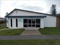
 view gallery view gallerySW6.8 km |  Uniting Church - Harrington, NSW, Australia Uniting Church - Harrington, NSW, Australia
in Religious Buildings Multifarious This building that looks a bit like beach shack is the Uniting Church for Harrington. posted by: Grahame Cookie location: New South Wales, Australia date approved: 04/05/2024 last visited: never |
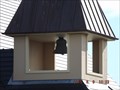
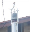 view gallery view gallerySW6.8 km |  St Andrew's Presbyterian/Uniting Bell Tower, Harrington, NSW, Australia St Andrew's Presbyterian/Uniting Bell Tower, Harrington, NSW, Australia
in Bell Towers A smaller Bell Tower is mounted in front of the Uniting Church of Harrington. posted by: Grahame Cookie location: New South Wales, Australia date approved: 04/06/2024 last visited: never |
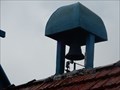 view gallery view gallerySW6.8 km | Anglican Mounted Bell Tower - Harrington, NSW, Australia in Bell Towers This a smaller covered mounted Bell Tower of the St Peter's Anglican Church. posted by: Grahame Cookie location: New South Wales, Australia date approved: 04/06/2024 last visited: never |
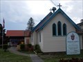 view gallery view gallerySW6.8 km |  St Peter's Anglican Church - Harrington, NSW, Australia St Peter's Anglican Church - Harrington, NSW, Australia
in Anglican and Episcopal Churches This wood-frame and clad Church for the Anglican locals of Harrington. posted by: Grahame Cookie location: New South Wales, Australia date approved: 04/05/2024 last visited: never |
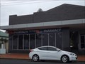 view gallery view gallerySW6.9 km |  Harrington Beach, NSW, Australia Harrington Beach, NSW, Australia
in Independent Pharmacies Harrington Beach Pharmacy overlooks the entrance to the Manning River and breakwall. posted by: Grahame Cookie location: New South Wales, Australia date approved: 10/20/2016 last visited: never |
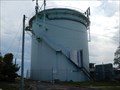 view gallery view gallerySW6.9 km |  Reservoir - Harrington, NSW, Australia Reservoir - Harrington, NSW, Australia
in Water Towers This tall metal cylinder is on High Street Harrington posted by: Grahame Cookie location: New South Wales, Australia date approved: 04/05/2024 last visited: never |
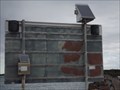 view gallery view gallerySW7.4 km |  Bar Warning - Harrington, NSW, Australia Bar Warning - Harrington, NSW, Australia
in Solar Power On the 'training wall' of the Manning River at Harrington, is the Solar Powered Warning sign for the dangers of the sand bar. posted by: Grahame Cookie location: New South Wales, Australia date approved: 02/19/2018 last visited: never |
 view gallery view gallerySW9.5 km | Harrington "Community Church", NSW, Australia in Bell Towers In the fore court of the Harrington Waters Shopping Centre is a very quaint church (used by the Anglican and Salvation Army Churches - with a functional bell tower posted by: Grahame Cookie location: New South Wales, Australia date approved: 10/09/2016 last visited: never |
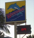 view gallery view gallerySW10.6 km |  Weeroona Holiday Park, Manning Point, NSW, Australia Weeroona Holiday Park, Manning Point, NSW, Australia
in Time and Temperature Signs On the road to Manning Point (on Mitchells Island) is the Weeroona Holiday Park / Caravan Park, which has multi-display out the front. posted by: Grahame Cookie location: New South Wales, Australia date approved: 05/22/2017 last visited: never |
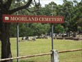 view gallery view galleryNW11.7 km |  Moorland Cemetery, Moorland, NSW, Australia Moorland Cemetery, Moorland, NSW, Australia
in Worldwide Cemeteries Just off of the Pacific Highway is the monument cemetery and columbarium for the Moorland community. posted by: Grahame Cookie location: New South Wales, Australia date approved: 07/21/2017 last visited: never |
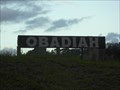 view gallery view galleryNW12.1 km |  Obadiah, Mid North Coast, NSW Obadiah, Mid North Coast, NSW
in Names From the Bible Formally called Camp Obadiah this Christian community (set on 75 acres) now calls itself Obadiah. It is about 4 hours drive north of Sydney. posted by: Grahame Cookie location: New South Wales, Australia date approved: 03/03/2015 last visited: never |
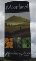 view gallery view galleryNW12.6 km |  Moorland, NSW, Australia Moorland, NSW, Australia
in Artistic Welcome Signs Moorland is small rural community on the Mid North Coast of New South Wales. About 270 km north of Sydney. posted by: Grahame Cookie location: New South Wales, Australia date approved: 07/20/2017 last visited: never |
 view gallery view galleryNW12.6 km | Moorland Rural Fire Brigade in Firehouses This orange brick building is for the local volunteer fire fighters of Moorland, on the NSW MidNorth Coast. posted by: Grahame Cookie location: New South Wales, Australia date approved: 07/11/2022 last visited: never |
|