 view gallery view gallery SW2.4 km SW2.4 km
|   The Falkirk Wheel The Falkirk Wheel
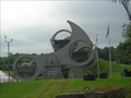
in Waterway Locks, Planes and Lifts As the world’s first and only rotating boat lift, The Falkirk Wheel or Millennium Link, is quite simply unique. It cost about 84 Million Pounds, and lowers boats 115' in a single 1/2 rotation. posted by:  Taftster Taftster location: United Kingdom date approved: 05/30/2006 last visited: 06/15/2023 |
 view gallery view gallerySW2.4 km |  Falkirk Wheel Penny Smasher, Falkirk, Southern Scotland Falkirk Wheel Penny Smasher, Falkirk, Southern Scotland
in Penny Smashers Penny Smasher inside Falkirk Wheel visitor centre. posted by:  xtqx1 xtqx1 location: Southern Scotland, United Kingdom date approved: 08/17/2015 last visited: 02/14/2016 |
 view gallery view gallerySW2.4 km |  Falkirk Wheel - Falkirk, Scotland, UK Falkirk Wheel - Falkirk, Scotland, UK
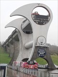
in Satellite Imagery Oddities [EN] The Falkirk Wheel is a rotating boat lift, connecting the Forth and Clyde Canal to the Union Canal.
[FR] La roue de Falkirk, en anglais Falkirk Wheel, est un ascenseur à bateaux rotatif, reliant le Forth and Clyde Canal à l'Union Canal. posted by: pmaupin location: Southern Scotland, United Kingdom date approved: 04/24/2024 last visited: never |
 view gallery view gallerySW2.4 km |  Falkirk Wheel - Falkirk, Scotland Falkirk Wheel - Falkirk, Scotland
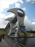
in Wikipedia Entries The Falkirk Wheel is a rotating boat lift in Falkirk, Scotland. posted by: Marine Biologist location: Southern Scotland, United Kingdom date approved: 09/06/2014 last visited: 03/19/2017 |
 view gallery view gallerySW2.4 km |  Falkirk Wheel - Falkirk, Scotland Falkirk Wheel - Falkirk, Scotland
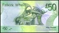
in Numismatic Photographs The Falkirk Wheel is found on the back of £50 notes that were issued by the Royal Bank of Scotland. posted by: Marine Biologist location: Southern Scotland, United Kingdom date approved: 09/03/2014 last visited: 06/15/2023 |
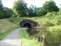 view gallery view gallerySW2.7 km |  North Entrance - Rough Castle Tunnel - Union Canal - Falkirk, Scotland, UK North Entrance - Rough Castle Tunnel - Union Canal - Falkirk, Scotland, UK
in Canal Tunnels This is the North Entrance of Rough Castle Tunnel, in Union Canal, located very near from the famous Falkirk Wheel posted by: tmob location: Southern Scotland, United Kingdom date approved: 08/28/2012 last visited: 06/15/2023 |
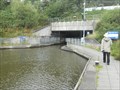 view gallery view gallerySW2.7 km | South Entrance - Roughcastle Tunnel - Union Canal - Falkirk, Scotland, UK in Canal Tunnels This is the South Entrance of Roughcastle Tunnel in Union Canal, which is located very close to the famous Falkirk Wheel. posted by: Marine Biologist location: Southern Scotland, United Kingdom date approved: 09/04/2014 last visited: 06/15/2023 |
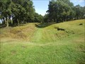
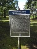 view gallery view gallerySW3.1 km |  Antonine Wall Rough Castle - Falkirk, Scotland Antonine Wall Rough Castle - Falkirk, Scotland
in UK Historical Markers The Antonine Wall was built nearly 2,000 years ago in the year 142. It is a stone and turf fortification built by the Romans across what is now the Central Belt of Scotland and represents the northernmost frontier barrier of the Roman Empire. posted by: Marine Biologist location: Southern Scotland, United Kingdom date approved: 09/05/2014 last visited: 02/14/2016 |
 view gallery view gallerySW3.1 km | Antonine Wall - Falkirk, Scotland in Wikipedia Entries The Antonine Wall was built nearly 2,000 years ago in the year 142. It is a stone and turf fortification built by the Romans across what is now the Central Belt of Scotland and represents the northernmost frontier barrier of the Roman Empire. posted by: Marine Biologist location: Southern Scotland, United Kingdom date approved: 09/06/2014 last visited: 02/14/2016 |
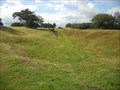 view gallery view gallerySW3.1 km |  Antonine Wall (Frontiers of the Roman Empire) - Falkirk, Scotland Antonine Wall (Frontiers of the Roman Empire) - Falkirk, Scotland
in World Heritage Sites The Antonine Wall was built nearly 2,000 years ago in the year 142. It is a stone and turf fortification built by the Romans across what is now the Central Belt of Scotland and represents the northernmost frontier barrier of the Roman Empire. posted by: Marine Biologist location: Southern Scotland, United Kingdom date approved: 09/06/2014 last visited: 02/14/2016 |
 view gallery view gallerySW3.1 km |  Antonine Wall - Falkirk, Scotland Antonine Wall - Falkirk, Scotland
in Ancient Roman Civilization The Antonine Wall was built nearly 2,000 years ago in the year 142. It is a stone and turf fortification built by the Romans across what is now the Central Belt of Scotland and represents the northernmost frontier barrier of the Roman Empire. posted by: Marine Biologist location: Southern Scotland, United Kingdom date approved: 09/05/2014 last visited: 02/14/2016 |
 view gallery view gallerySW3.1 km |  Antonine Wall - Falkirk, Scotland Antonine Wall - Falkirk, Scotland
in English Heritage - Cadw - Historic Scotland The Antonine Wall was built nearly 2,000 years ago in the year 142. It is a stone and turf fortification built by the Romans across what is now the Central Belt of Scotland and represents the northernmost frontier barrier of the Roman Empire. posted by: Marine Biologist location: Southern Scotland, United Kingdom date approved: 09/05/2014 last visited: 02/14/2016 |
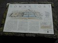 view gallery view gallerySW3.2 km | The Roman Fort - Falkirk, Scotland in UK Historical Markers The Roman Fort marker is located adjacent to the Antonine Wall in Falkirk, Scotland. posted by: Marine Biologist location: Southern Scotland, United Kingdom date approved: 09/05/2014 last visited: 02/14/2016 |
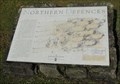 view gallery view gallerySW3.2 km | The Northern Defences - Falkirk, Scotland in UK Historical Markers The Northern Defences marker is located adjacent to the Antonine Wall in Falkirk, Scotland. posted by: Marine Biologist location: Southern Scotland, United Kingdom date approved: 09/05/2014 last visited: never |
 view gallery view gallery E4.2 km E4.2 km
|  The Kelpies - Falkirk, Scotland The Kelpies - Falkirk, Scotland
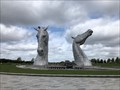
in Figurative Public Sculpture The Kelpies are 30 metre high horse-head sculptures depicting Kelpies (shape-shifting water spirits) located between Falkirk and Grangemouth. posted by: TeamXW location: Southern Scotland, United Kingdom date approved: 07/14/2021 last visited: 03/24/2022 |
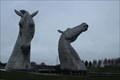 view gallery view galleryE4.2 km | The Kelpies - Falkirk, Scotland, UK in Wikipedia Entries [EN] The Kelpies are two outdoor sculptures measuring around 30 meters, located near the Forth and Clyde Canal.
[FR] The Kelpies sont deux sculptures en plein air grandes d'une trentaine de mètres, situées près du canal de Forth et Clyde. posted by: pmaupin location: Southern Scotland, United Kingdom date approved: 04/23/2024 last visited: never |
 view gallery view galleryE4.2 km | The Kelpies - Falkirk, Scotland, UK in Satellite Imagery Oddities [EN] The Kelpies are two outdoor sculptures measuring around 30 meters, located near the Forth and Clyde Canal. [FR] The Kelpies sont deux sculptures en plein air grandes d'une trentaine de mètres, situées près du canal de Forth et Clyde. posted by: pmaupin location: Southern Scotland, United Kingdom date approved: 04/24/2024 last visited: never |
 view gallery view galleryE4.2 km |  The Kelpies - Falkirk, Scotland The Kelpies - Falkirk, Scotland
in Epic Beings and Creatures Two 30 metre high horse-head sculptures depicting Kelpies (shape-shifting water spirits) located between Falkirk and Grangemouth. posted by: TeamXW location: Southern Scotland, United Kingdom date approved: 07/16/2021 last visited: 06/15/2023 |
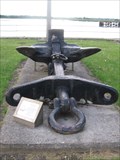 view gallery view gallery NE8 km NE8 km
|  Anchor - Kincardine Sailors Memorial Anchor - Kincardine Sailors Memorial
in Anchors An Anchor serving as a memorial to the Ship-Builders, Owners, Masters and crews of ships registered in their own Port at Kincardine. posted by: fishteers location: Southern Scotland, United Kingdom date approved: 06/01/2010 last visited: 05/27/2010 |
 view gallery view galleryNE8.4 km |  Lodge St John Tulliallan No.598, Kincardine, Scotland. Lodge St John Tulliallan No.598, Kincardine, Scotland.
in Masonic Temples Lodge St John Tulliallan No.598, Kincardine, Scotland posted by: Jimmy1361 location: Southern Scotland, United Kingdom date approved: 08/28/2012 last visited: 03/29/2014 |
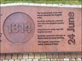 view gallery view gallery NW10.8 km NW10.8 km
|  Battle of Bannockburn, 1296 - 2014, Stirling, Scotland, UK Battle of Bannockburn, 1296 - 2014, Stirling, Scotland, UK
in Timelines The Battle of Bannockburn (Blàr Allt nam Bànag, often mistakenly called Blàr Allt a' Bhonnaich in Scottish Gaelic) (24 June 1314) was a significant Scottish victory in the First War of Scottish Independence, and a landmark in Scottish history. posted by: Bear and Ragged location: Northern Scotland, United Kingdom date approved: 11/28/2015 last visited: 01/21/2022 |
 view gallery view gallery W10.9 km W10.9 km
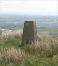
|  Birns Hill Triangulation Pillar Birns Hill Triangulation Pillar
in U.K. and Ireland Trigpoints Trigpoint on 351m Birns Hill near Denny. posted by: agentmancuso location: United Kingdom date approved: 01/21/2008 last visited: 05/31/2006 |
 view gallery view gallery N11.7 km N11.7 km
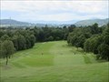
|  Braehead Golf Club - Clackmannanshire, Scotland Braehead Golf Club - Clackmannanshire, Scotland
in Public and Private Golf Courses Hilly parkland course in central Scotland, just west of the town of Alloa. posted by: creg-ny-baa location: Northern Scotland, United Kingdom date approved: 07/30/2023 last visited: never |
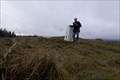 view gallery view galleryNW12.4 km | Sauchie Crag - North Third Reservoir, Scotland in U.K. and Ireland Trigpoints A triangulation pillar on top of a hill.
It has a flush bracket with OS BM S3631 on it.
From the waymark you have will have a very nice view. posted by: lingbeek location: Southern Scotland, United Kingdom date approved: 03/11/2014 last visited: 08/03/2019 |
 view gallery view galleryE12.6 km |  Culross Palace Medieval Garden Culross Palace Medieval Garden
in Botanical Gardens Managed by the National Trust for Scotland, this enchanting, multi-tiered garden offers breathtaking views and a wide variety of plants and flowers. posted by: DnRseekers location: Northern Scotland, United Kingdom date approved: 08/31/2014 last visited: 05/17/2014 |
|