 view gallery view gallery S1.4 km S1.4 km
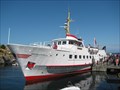
|   Christiansø ferry landing Christiansø ferry landing
in Ferries and Ferry Landings Ferry mainly for tourists - only about 90 people live on the islands and more than 40.000 tourists per year visits the Ertholmene archipelago. posted by:  Viburnus Viburnus location: Denmark date approved: 12/21/2016 last visited: 07/22/2015 |
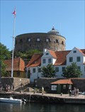 view gallery view galleryS1.4 km |  Christiansø Fyr Christiansø Fyr
in Coastal Lighthouses Christiansø lighthouse ('fyr' in Danish) is located on the top of the Store Tårn (Big tower), former part of the fortress on the Christian's island (= Christiansø). posted by: Viburnus location: Denmark date approved: 12/20/2016 last visited: 07/22/2015 |
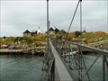 view gallery view galleryS1.4 km |  Bro mellem Christiansø og Frederiksø Bro mellem Christiansø og Frederiksø
in Moving Bridges Pedestrian suspension bridge between Christiansø and Frederiksø. The bridge consists of two halves that can be swung aside to allow through larger ships (which happens only once a year). posted by: Viburnus location: Denmark date approved: 12/19/2016 last visited: 07/22/2015 |
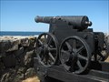 view gallery view galleryS1.8 km |  Old cannons at Christiansø fort Old cannons at Christiansø fort
in Static Artillery Displays Historic naval base in the central Baltic Sea. Fort was built on Christiansø and Frederiksø in 1684 and served as an outpost for the Danish Navy until 1855. posted by: Viburnus location: Denmark date approved: 12/24/2016 last visited: 07/22/2015 |
 view gallery view gallery SW19.3 km SW19.3 km
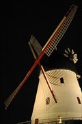
|  Gudhjem Mølle Gudhjem Mølle
in Windmills Gudhjem mølle is Denmarks largest windmill. posted by: Yehaah location: Denmark date approved: 01/18/2011 last visited: 08/10/2015 |
 view gallery view gallerySW21.4 km |  Magnetbakken - Bornholm, Danmark Magnetbakken - Bornholm, Danmark
in Vortexes, Mystery Spots, and Gravity Hills Magnetbakken er et optisk bedrag...Magnetic Hill is an optical illusion posted by: Walking Boots location: Denmark date approved: 05/14/2020 last visited: never |
 view gallery view gallerySW21.6 km |  Stavehøl, Bornholm, Denmark Stavehøl, Bornholm, Denmark
in Waterfalls The waterfall Stavehoel posted by: Walking Boots location: Denmark date approved: 02/22/2013 last visited: never |
 view gallery view gallerySW22.4 km |  N 55° 13.541 E 014° 53.155 - Døndalen, Bornholm, Denmark N 55° 13.541 E 014° 53.155 - Døndalen, Bornholm, Denmark
in Coordinate Palindromes This point of coordinate palindrome is located close to a forest pathway leading to the largest waterfall in Denmark. The place is easily accessible for everyone. posted by: taxoft location: Denmark date approved: 08/03/2016 last visited: never |
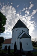
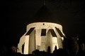 view gallery view gallerySW22.9 km |  Østerlars round church Østerlars round church
in Medieval Churches Østerlars Church, located 5 km south of Gudhjem on the Danish island of Bornholm, is the largest and oldest of the island's four round churches. posted by: Yehaah location: Denmark date approved: 01/21/2011 last visited: 07/30/2019 |
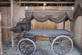 view gallery view gallerySW22.9 km |  Rustvogn - Østerlars Kirke - Bornholm - Denmark Rustvogn - Østerlars Kirke - Bornholm - Denmark
in Carriages and Coaches on Permanent Display Den sidste rejse...The last journey posted by: Walking Boots location: Denmark date approved: 03/12/2020 last visited: never |
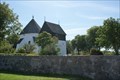 view gallery view gallerySW22.9 km |  Østerlars Kirke, Bornholm, Danmark Østerlars Kirke, Bornholm, Danmark
in Great Buildings of the World Østerlars Kirke er den største og ældste af Bornholms fire rundkirker...Østerlars Church is the largest and oldest of Bornholm's four round churches posted by: Walking Boots location: Denmark date approved: 03/18/2020 last visited: never |
 view gallery view gallerySW24.1 km |  Østermarie church ruin Østermarie church ruin
in Preserved Architectural Remnants and Ruins Right next to the "new" church, you can find the remains from the older one. posted by: Yehaah location: Denmark date approved: 01/18/2011 last visited: 08/04/2016 |
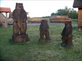 view gallery view gallerySW24.5 km |  Oregon Bears Oregon Bears
in Bear Statues Lille, privat skulpturpark med udskårne bjørnefigurer.
Little, private sculpture park with wooden bear statues. posted by: kallehaugerne location: Denmark date approved: 11/22/2012 last visited: 04/12/2012 |
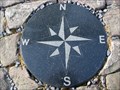 view gallery view galleryS25.6 km |  Bornholm Compass Rose Bornholm Compass Rose
in Compass Roses A compass rose made of granite on the island Bornholm, Denmark. posted by: achamian location: Denmark date approved: 09/02/2009 last visited: 05/29/2014 |
 view gallery view gallery W26.2 km W26.2 km
|  Stenhuggerstien - Bornholm - Danmark Stenhuggerstien - Bornholm - Danmark
in Hiking and walking trailheads Stenhuggerstien 5,5 km lang rute ...The Quarry Worker’s Footpath 5,5 km long route posted by: Walking Boots location: Denmark date approved: 03/21/2020 last visited: never |
 view gallery view gallerySW26.6 km | Olsker Round Church in Medieval Churches The round church in Olsker posted by: Yehaah location: Denmark date approved: 01/21/2011 last visited: 10/14/2012 |
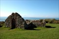 view gallery view galleryW26.9 km | Salomons Kapel in Preserved Architectural Remnants and Ruins Solomon's chapel is a medieval chapel located on Bornholm Hammer Odde on the coast northwest. posted by: Yehaah location: Denmark date approved: 01/19/2011 last visited: 08/03/2016 |
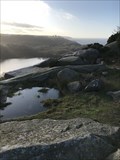 view gallery view galleryW27 km |  Høje Meder udsigt - Bornholm - Danmark Høje Meder udsigt - Bornholm - Danmark
in Scenic Overlooks Udsigt over Østersøen og Hammershus...View of the Baltic sea and Hammershus posted by: Walking Boots location: Denmark date approved: 03/13/2020 last visited: never |
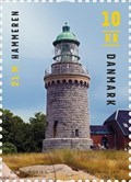 view gallery view galleryW27.4 km |  Frimærke Hammeren Fyr - Bornholm, Danmark Frimærke Hammeren Fyr - Bornholm, Danmark
in Philatelic Photographs Hammeren Fyrtårn fra frimærkeserien Danske Fyrtårne... Hammeren Lighthouse from the stamp series Danish Lighthouses. posted by: Walking Boots location: Denmark date approved: 05/23/2020 last visited: never |
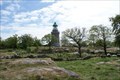 view gallery view galleryW27.4 km | Hammeren Fyr - Bornholm, Danmark in Coastal Lighthouses Hammeren Fyr kan ses på Bornholms nordspids...Hammeren Lighthouse is located on the northwestern tip of Bornholm. posted by: Walking Boots location: Denmark date approved: 05/15/2020 last visited: never |
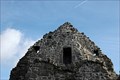
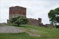 view gallery view galleryW28 km | Hammershus - Bornholm, Danmark in Preserved Architectural Remnants and Ruins På Bornholms nordspids står de imponerende ruiner af middelalderfæstningen Hammershus...At the northern tip of Bornholm you'll find the impressive medieval fortress of Hammershus. posted by: Walking Boots location: Denmark date approved: 05/14/2020 last visited: never |
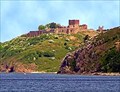 view gallery view galleryW28 km |  Hammershus Hammershus
in Castles Hammershus posted by: Gade location: Denmark date approved: 01/26/2006 last visited: 07/07/2017 |
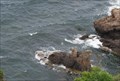 view gallery view galleryW28.2 km |  Kamelhovederne - Bornholm, Danmark Kamelhovederne - Bornholm, Danmark
in Simulacra I bugten ved Hammershus er den lille klippeø med de berømte kamelhoveder. posted by: Walking Boots location: Denmark date approved: 10/17/2020 last visited: never |
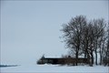 view gallery view gallerySW28.3 km |  WWII German Barrack Bunker WWII German Barrack Bunker
in World War II Sites German Barrack Bunker, where the nearby radar stations personnel lived posted by: Yehaah location: Denmark date approved: 01/19/2011 last visited: 04/12/2012 |
 view gallery view gallerySW28.5 km |  WWII German Radar Bornholm WWII German Radar Bornholm
in Luftwaffe Radar Ruins The remains of the German WWII radar on Bornholm posted by: Yehaah location: Denmark date approved: 01/18/2011 last visited: 04/13/2013 |
|