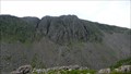
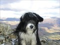
 view gallery view gallery SE1 km SE1 km
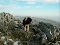
|   Brim Fell, Brim Fell,
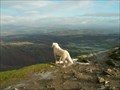
in Mountain Summits Brim Fell is one of the Coniston Fells and stands at 2611 feet. posted by:  fellsmanhiker fellsmanhiker location: United Kingdom date approved: 01/19/2008 last visited: 02/12/2015 |
 view gallery view gallery NW1.1 km NW1.1 km
| Grey Friar in Mountain Summits Grey Friar ,stands at 2536 feet. posted by: fellsmanhiker location: United Kingdom date approved: 01/19/2008 last visited: 02/13/2015 |
 view gallery view gallery NE1.3 km NE1.3 km
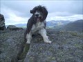
| Swirl How in Mountain Summits Swirl How is one of the Coniston group of Fells in the Lake District of Cumbria,England. posted by: fellsmanhiker location: United Kingdom date approved: 10/07/2008 last visited: 02/12/2015 |
 view gallery view gallery N1.4 km N1.4 km
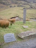
|  Halifax Bomber memorial ,Great Carrs Lake District England. Halifax Bomber memorial ,Great Carrs Lake District England.
in Plane Crash Sites On the 22nd.October 1944 the 8 man crew of Halifax Bomber lost there lives when the aircraft crashed near the summit of Great Carrs mountain. posted by: fellsmanhiker location: United Kingdom date approved: 04/10/2008 last visited: 02/12/2015 |
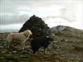
 view gallery view galleryN1.6 km | Great Carrs in Mountain Summits Great Carrs is a mountain of The Coniston Group of Fells. posted by: fellsmanhiker location: United Kingdom date approved: 10/08/2008 last visited: 02/12/2015 |
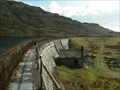 view gallery view gallery SW1.6 km SW1.6 km
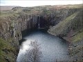
|  Seathwaite Tarn Dam. Seathwaite Tarn Dam.
in Water Dams Seathwaite Tarn Reservoir,Cumbria England posted by: fellsmanhiker location: United Kingdom date approved: 01/24/2008 last visited: 01/12/2008 |
 view gallery view gallery S1.6 km S1.6 km
| Dow Crag in Mountain Summits What better way is there of climbing a mountain than to do a rock climb direct to the summit. My friend and I did the "Ordinary Route" on C Buttress on a beautiful sunny day in March 2007. posted by: charlieg0pzo location: United Kingdom date approved: 03/25/2007 last visited: 02/12/2015 |
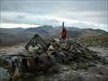
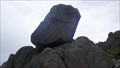
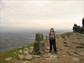 view gallery view gallerySE1.8 km |  CONISTON OLD MAN TRIG PILLAR CONISTON OLD MAN TRIG PILLAR
in U.K. and Ireland Trigpoints Coniston Old Man, Cumbria, England. (Lake district National park) It sits at an elevation of 2634 ft above sea level. posted by: Grimspound & Jem location: United Kingdom date approved: 09/04/2006 last visited: 02/12/2015 |
 view gallery view gallerySE1.8 km | Coniston Old Man in Mountain Summits Coniston Old Man (G/LD-013) This popular lakeland summit is near the village of Coniston in the southern Lake District. posted by: charlieg0pzo location: United Kingdom date approved: 03/25/2007 last visited: 02/12/2015 |
 view gallery view galleryS1.8 km |  Dow Crag, Coniston, Cumbria Dow Crag, Coniston, Cumbria
in Established Rock Climbing Areas Dow Crag was first climbed in 1904 and has remained a classic crag since. Often cold, needing a walk in, ending up the scree to the foot of the crag. posted by:  flipflopnick flipflopnick location: North West England, United Kingdom date approved: 07/12/2010 last visited: 12/20/2015 |
 view gallery view galleryS1.9 km |  Perched Boulders, Goat Crag, Coniston Cumbria Perched Boulders, Goat Crag, Coniston Cumbria
in Places of Geologic Significance Scattered all over Goat Crag are perched boulders. This is the most prominent boulder nearest the path. posted by: flipflopnick location: North West England, United Kingdom date approved: 06/24/2011 last visited: never |
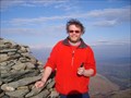
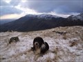 view gallery view galleryNE2.3 km | Black Sails. in Mountain Summits Black Sails stands at 2443 feet and is of the Coniston Range. posted by: fellsmanhiker location: United Kingdom date approved: 01/19/2008 last visited: 08/20/2014 |
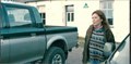 view gallery view gallery E2.6 km E2.6 km
|  YHA, Coppermines, Coniston, Cumbria, UK - Deep Water (2019) YHA, Coppermines, Coniston, Cumbria, UK - Deep Water (2019)
in Movie Locations Lisa confesses to Joe in front of the Coppermines YHA posted by: bill&ben location: North West England, United Kingdom date approved: 09/07/2019 last visited: never |
 view gallery view galleryNE2.7 km | Wetherlam, in Mountain Summits Wetherlam stands at 2502 feet and is one of the Coniston Fells. posted by: fellsmanhiker location: United Kingdom date approved: 01/19/2008 last visited: 02/12/2015 |
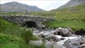 view gallery view galleryS3.1 km |  Torver Bridge, Walna Scar Road, Cumbria Torver Bridge, Walna Scar Road, Cumbria
in Stone Bridges Torver Bridge carries the B.O.A.T. Walna Scar road over Torver Beck. posted by: flipflopnick location: North West England, United Kingdom date approved: 07/13/2010 last visited: 06/09/2013 |
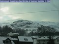 view gallery view gallerySE3.2 km |  Old Man of Coniston Web camera, Cumbria Old Man of Coniston Web camera, Cumbria
in Web Cameras Skyline view of Old Man of Coniston, a 'fell' (mountain) in English Lake District. Summit is at an altitude of 803 metres.
Updated every five minutes during daylight hours. Looking west. Timezone GMT posted by: flipflopnick location: North West England, United Kingdom date approved: 03/12/2006 last visited: 09/25/2009 |
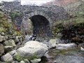 view gallery view gallerySE3.2 km | Miner's Bridge, Coniston, Cumbria in Stone Bridges Miner's Bridge is at the entrance to Coppermines valley above Coniston village. The two paths either side of Church Beck meet here. 10 minutes walk from free parking. posted by: flipflopnick location: North West England, United Kingdom date approved: 12/14/2007 last visited: 02/16/2008 |
 view gallery view galleryN3.5 km |  Three Shires Stone, Wrynose Pass, Cumbria Three Shires Stone, Wrynose Pass, Cumbria
in Border Crossings Three Shires Stone is on the summit of Wrynose Pass, linking Langdale with Dunnerdale in Cumbria. It used to mark where the old counties of Lancashire, Westmorland and Cumberland came together, as this area is all in the county of Cumbria now. posted by: flipflopnick location: North West England, United Kingdom date approved: 04/20/2007 last visited: 09/18/2019 |
 view gallery view galleryS3.5 km |  Banishead water falls. Banishead water falls.
in Man-made Waterfalls Banishead Waterfalls posted by: fellsmanhiker location: United Kingdom date approved: 01/23/2008 last visited: 02/06/2008 |
 view gallery view gallerySE3.7 km |  Coniston Hydro Gen - Coniston, Cumbria, England Coniston Hydro Gen - Coniston, Cumbria, England
in Hydroelectric Power Stations Coniston's newest power supply was commissioned in 2007. Fed from water from Church Beck. This is not Coniston's first hydro power scheme. Read on .. posted by: flipflopnick location: North West England, United Kingdom date approved: 08/31/2012 last visited: never |
 view gallery view galleryNE3.7 km | Birk Fell. in Mountain Summits Birk fell stands at 1800 feet and is a summit of the Coniston massive. posted by: fellsmanhiker location: United Kingdom date approved: 01/19/2008 last visited: 08/13/2014 |
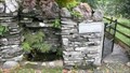 view gallery view gallerySE3.9 km |  Dixon Ground Water Trough, Coniston, Cumbria Dixon Ground Water Trough, Coniston, Cumbria
in Historic Upping Stones, Hitching Posts, and Carriage Blocks Dixon Ground is the old farm which lends its name to this area of Coniston. The water trough is on the main route up to Coppermines valley. posted by: flipflopnick location: North West England, United Kingdom date approved: 08/31/2012 last visited: never |
 view gallery view gallerySE3.9 km |  1762 - Dixon Ground Farm, Coniston, Cumbria 1762 - Dixon Ground Farm, Coniston, Cumbria
in Dated Buildings and Cornerstones Dixon Ground Farm is a grade 2 listed building, available to stay in as a holiday rental. The farm gives its name to this area of Coniston. posted by: flipflopnick location: North West England, United Kingdom date approved: 01/04/2013 last visited: never |
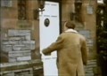 view gallery view gallerySE3.9 km | Sun Hotel, Coniston, Cumbria, UK – Across the Lake (1988) in Movie Locations The Sun Hotel was used as the hotel where Campbell stayed whilst preparing for the record attempt. posted by: bill&ben location: North West England, United Kingdom date approved: 08/30/2011 last visited: 02/16/2023 |
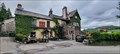 view gallery view gallerySE3.9 km |  The Sun Inn - Coniston, Cumbria The Sun Inn - Coniston, Cumbria
in Pubs and Inns The Sun Inn / Hotel. A 16th century inn on Station Road, Coniston. posted by: SMacB location: North West England, United Kingdom date approved: 02/15/2023 last visited: never |
|