 view gallery view gallery SE1.3 km SE1.3 km
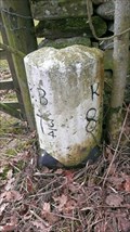
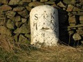
|   Borrowbridge 7¾ - Kirkby Lonsdale 8¾ Milestone, Killington, Cumbria Borrowbridge 7¾ - Kirkby Lonsdale 8¾ Milestone, Killington, Cumbria
in Milestones A milestone off the main turnpike between Sedbergh and Kirkby Lonsdale. On a connection leading to Kendal to Sedbergh turnpike. Sedbergh was a hub of turnpikes. posted by:  flipflopnick flipflopnick location: North West England, United Kingdom date approved: 03/06/2013 last visited: never |
 view gallery view gallery N2.4 km N2.4 km
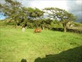
|  Fox's Pulpit Quaker burial ground, Sedbergh, Cumbria Fox's Pulpit Quaker burial ground, Sedbergh, Cumbria
in Worldwide Cemeteries High up on the fell side of Firbank next to Fox's Pulpit is a disused burial ground. A classic Quaker burial ground with shoulder high walls, squarish outline with one entrance gap. No horizontal stones in wall to form seats. posted by: flipflopnick location: North West England, United Kingdom date approved: 08/06/2007 last visited: 02/13/2008 |
 view gallery view gallery E2.6 km E2.6 km
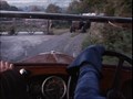
|  Holme Open Farm, Middleton, Cumbria, UK – Poirot, Double Sin (1990) Holme Open Farm, Middleton, Cumbria, UK – Poirot, Double Sin (1990)
in Movie Locations The entrance gateway to Holme Open Farm was used to stage a car crash in this episode of Poirot. posted by: bill&ben location: North West England, United Kingdom date approved: 08/30/2011 last visited: never |
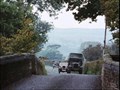 view gallery view gallerySE2.6 km | Middleton Bridge, Middleton, Cumbria, UK – Poirot, Double Sin (1990) in Movie Locations This bridge is used as part of a car chase sequence. Here Captain Hastings undertakes a lorry. posted by: bill&ben location: North West England, United Kingdom date approved: 08/30/2011 last visited: never |
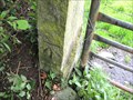 view gallery view galleryE2.9 km |  Cut Benchmark - A684 - Sedbergh - Cumbria - UK Cut Benchmark - A684 - Sedbergh - Cumbria - UK
in U.K. and Ireland Trigpoints Cut mark on S face of gatepost at W side of gateway. posted by:  BenchmarkTraveller BenchmarkTraveller location: North West England, United Kingdom date approved: 09/10/2011 last visited: never |
 view gallery view gallery NW2.9 km NW2.9 km
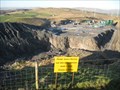
|  Roan Edge Quarry - Cumbria, UK Roan Edge Quarry - Cumbria, UK
in Active Quarries Roan Edge quarry has come back to life in the last few years after being granted planning permission for an extension. It produces high-performance gritstone for use in road building. posted by: martlakes location: North West England, United Kingdom date approved: 02/11/2008 last visited: 02/12/2008 |
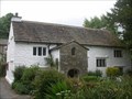 view gallery view galleryE2.9 km |  Briggflatts Meeting House Briggflatts Meeting House
in Wikipedia Entries Brigflatts Meeting House is the oldest purpose built Quaker meeting place still in use in north of England. One 'g' is preferred spelling. posted by: flipflopnick location: North West England, United Kingdom date approved: 02/05/2008 last visited: never |
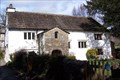 view gallery view galleryE2.9 km |  Brigflatts Meeting House, Cumbria Brigflatts Meeting House, Cumbria
in This Old Church Brigflatts Meeting House is the oldest Quaker meeting house. Purpose built on land bought by the Religious Society of Friends from a fellow Quaker. posted by: flipflopnick location: North West England, United Kingdom date approved: 02/05/2008 last visited: never |
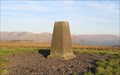 view gallery view gallery W2.9 km W2.9 km
| Roan Edge Trig - Cumbria, UK in U.K. and Ireland Trigpoints A trig point in good nick and on an excellent view point. A bridleway gives access from the north or south. Easiest approach from north - park on quarry road. posted by: martlakes location: United Kingdom date approved: 02/11/2008 last visited: 04/19/2008 |
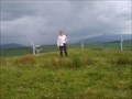
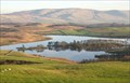 view gallery view galleryW2.9 km |  Roan Edge - Cumbria, UK Roan Edge - Cumbria, UK
in Scenic Overlooks Roan Edge gives an excellent panoramic view around South Lakeland. To the east the first hills of the Dales line the horizon above Killington Reservoir, north are the Howgills, west the arc of the Lakes, south looks down to Morecambe Bay. posted by: martlakes location: United Kingdom date approved: 02/12/2008 last visited: 02/13/2008 |
 view gallery view gallerySE3.1 km | Junction Jordan’s Lane and A683, Middleton, Cumbria, UK – Poirot, Double Sin (1990) in Movie Locations This junction is used in the car chase between an authoress and Captain Hastings in a Police car. posted by: bill&ben location: North West England, United Kingdom date approved: 08/30/2011 last visited: never |
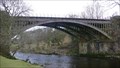 view gallery view galleryE3.2 km |  Rawthey Viaduct, Sedbergh, Cumbria Rawthey Viaduct, Sedbergh, Cumbria
in Photos Then and Now The viaduct over the river Rawthey used to carry the Low Gill to Ingleton railway, near Sedbergh in Cumbria. The bridge is off limits as it carries a gas pipeline across the river. Looking east. posted by: flipflopnick location: North West England, United Kingdom date approved: 01/18/2011 last visited: never |
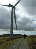 view gallery view galleryNW3.2 km |  Lambrigg Fell Wind Farm near Kendal Cumbria Lambrigg Fell Wind Farm near Kendal Cumbria
in Windmills Five wind turbines generating electricity, visible from M6 motorway, junction 37. Few hundred metres north of A684 between Kendal and Sedbergh. One kilometre from M6 J37, easy to visit. posted by: flipflopnick location: North West England, United Kingdom date approved: 05/09/2006 last visited: 04/16/2008 |
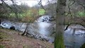 view gallery view galleryE3.7 km |  CONFLUENCE - Rivers Dee and Rawthey, Sedbergh, Cumbria CONFLUENCE - Rivers Dee and Rawthey, Sedbergh, Cumbria
in River Origins, Destinations and Confluences The Rawthey drains the eastern side of the Howgills. The Dee drains Dentdale. Here is where Dee empties in to Rawthey river. posted by: flipflopnick location: North West England, United Kingdom date approved: 12/18/2010 last visited: never |
 view gallery view galleryNW3.7 km |  Lambrigg Fell Lambrigg Fell
in Mountain Summits Lambrigg Fell (G/NW-046) This summit is found near the M6 motorway to the East of Kendal. It has a wind farm with 5 wind turbines. posted by: charlieg0pzo location: United Kingdom date approved: 06/26/2007 last visited: 08/16/2011 |
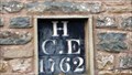 view gallery view galleryE4 km |  1762 - Low Birks, Sedbergh, Cumbria 1762 - Low Birks, Sedbergh, Cumbria
in Dated Buildings and Cornerstones There are two date stones on Low Birks. The older to mark the building by the Quaker miller, Charles Holme, and Elizabeth his wife. posted by: flipflopnick location: North West England, United Kingdom date approved: 01/15/2011 last visited: never |
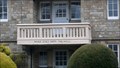 view gallery view galleryE4 km |  Psalm 121 - Newholme, Sedbergh, Cumbria Psalm 121 - Newholme, Sedbergh, Cumbria
in Etched in Stone The opening words of Psalm 121 are appropriately carved in to the balcony of Newholme, in Sedbergh. posted by: flipflopnick location: North West England, United Kingdom date approved: 12/20/2010 last visited: never |
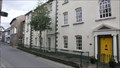 view gallery view galleryE4.5 km |  Martins bank (Evans House) - Sedbergh, Cumbria, UK Martins bank (Evans House) - Sedbergh, Cumbria, UK
in Converted Bank Buildings Before moving to purpose made building, Martins bank operated out of Evans House. posted by: flipflopnick location: North West England, United Kingdom date approved: 11/07/2017 last visited: never |
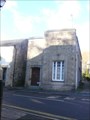 view gallery view galleryE4.7 km | Barclays (formerly Martins) bank - Sedbergh, Cumbria, UK in Converted Bank Buildings This branch was formerly a Martins bank, who built it. posted by: flipflopnick location: North West England, United Kingdom date approved: 11/07/2017 last visited: 04/18/2019 |
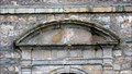
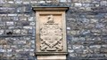 view gallery view galleryE4.7 km |  SEDBERGH SCHOOL Coat of Arms, CUMBRIA SEDBERGH SCHOOL Coat of Arms, CUMBRIA
in Coats of Arms Sedbergh School was founded by Roger Lupton and the school takes his Coat of Arms. This example is attached to the school library. posted by: flipflopnick location: North West England, United Kingdom date approved: 12/21/2010 last visited: 04/18/2019 |
 view gallery view galleryE4.7 km | 1716 - Sedbergh School Library, Cumbria in Dated Buildings and Cornerstones Sedbergh school's current library building was not always the school library. This site was used for the original grammar school. Grade 2 listed building. posted by: flipflopnick location: North West England, United Kingdom date approved: 12/19/2010 last visited: never |
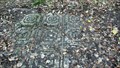 view gallery view galleryE4.7 km |  Akay House Floor, Sedbergh, Cumbria Akay House Floor, Sedbergh, Cumbria
in Mosaics Akay House had been knocked down and among the remains are the mosaic floor showing through the leaves of the woodland that has grown. posted by: flipflopnick location: North West England, United Kingdom date approved: 01/18/2011 last visited: never |
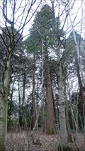 view gallery view galleryE4.7 km |  Redwoods, Akay, Sedbergh, Cumbria Redwoods, Akay, Sedbergh, Cumbria
in Sequoioideae Trees There are several redwood trees in the former garden of Akay House. The house has gone and the grounds are now a woodland owned by the school. posted by: flipflopnick location: North West England, United Kingdom date approved: 12/22/2010 last visited: never |
 view gallery view galleryW4.8 km | A684 New Hutton, Kendal in Milestones The A684 runs from Kendal to Sedbergh. Along the way it passes the hamlet of New Hutton. A painted milestone can be found near the turning to the hamlet. posted by: martlakes location: United Kingdom date approved: 02/11/2008 last visited: never |
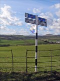 view gallery view gallery NE5 km NE5 km
|  Cycle Route 68 - Four Lane Ends - Howgill, UK Cycle Route 68 - Four Lane Ends - Howgill, UK
in Cycling Routes National Route 68 of the National Cycle Network is known as the Pennine Cycleway, and runs up the spine of England from Derby to Berwick-upon-Tweed. The route is fully opened and signed. posted by: martlakes location: United Kingdom date approved: 03/07/2008 last visited: never |
|