 view gallery view gallery W0.3 km W0.3 km
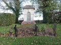
|   Aberford Cenotaph - Aberford, UK Aberford Cenotaph - Aberford, UK
in World War I Memorials and Monuments This cenotaph is situated to the south of the town of Aberford at the side of Bunkers Hill.
This road is the main north to south road that passes through the town and used to be part of the main route between London and Edinburgh. posted by:  dtrebilc dtrebilc location: Yorkshire, United Kingdom date approved: 11/03/2022 last visited: never |
 view gallery view gallery NW0.3 km NW0.3 km
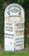
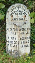
|  Milestone - Great North Road, Aberford, Yorkshire, UK. Milestone - Great North Road, Aberford, Yorkshire, UK.
in Milestones As with it's partner to the north of Aberford, this milestone would benefit from a bit of care. posted by:  HitchinLookers HitchinLookers location: Yorkshire, United Kingdom date approved: 10/09/2011 last visited: 01/29/2017 |
 view gallery view gallery N1 km N1 km
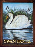
|  Swan - Main Street, Aberford, Yorkshire, UK. Swan - Main Street, Aberford, Yorkshire, UK.
in Pictorial Pub Signs This is a traditional depiction of a white swan. posted by: HitchinLookers location: Yorkshire, United Kingdom date approved: 12/20/2011 last visited: 01/29/2017 |
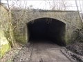
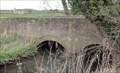
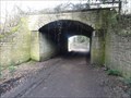 view gallery view galleryW1.1 km |  The Light Arch Bridge - Parlington, UK The Light Arch Bridge - Parlington, UK
in Arch Bridges This single arch stone bridge carries a carriageway over a former coal wagonway that later became a railway line. posted by: dtrebilc location: Yorkshire, United Kingdom date approved: 03/28/2021 last visited: never |
 view gallery view galleryW1.1 km |  The Light Arch Bridge - Parlington, UK The Light Arch Bridge - Parlington, UK
in Stone Bridges This single arch stone bridge carries a carriageway over a former coal wagonway that later became a railway line. posted by: dtrebilc location: Yorkshire, United Kingdom date approved: 03/29/2021 last visited: never |
 view gallery view galleryN1.1 km | The Arabian Horse - Aberford, UK in Pictorial Pub Signs This pub sign shows a black and white drawing of an Arabian Horse, a popular breed of horse especially in racing circles. posted by: dtrebilc location: Yorkshire, United Kingdom date approved: 06/30/2021 last visited: never |
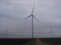 view gallery view gallery SE1.3 km SE1.3 km
|  Hook Moor Windfarm Turbine T2 - Hook Moor, UK Hook Moor Windfarm Turbine T2 - Hook Moor, UK
in Windmills This is wind turbine number T2 in a wind farm of 5 turbines. posted by: dtrebilc location: Yorkshire, United Kingdom date approved: 11/30/2020 last visited: 12/08/2020 |
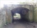
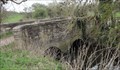
 view gallery view galleryW1.4 km |  The Dark Arch - Parlington, UK The Dark Arch - Parlington, UK
in Abandoned Train Tunnels This tunnel was originally erected to cover a wagonway on the Parlington Estate so that coal being moved from a coal mine could not be seen from Parlington Hall. It was later used by steam engines on a private railway line to carry the coal. posted by: dtrebilc location: Yorkshire, United Kingdom date approved: 03/28/2021 last visited: never |
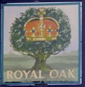 view gallery view galleryN1.4 km | Royal Oak - Main Street, Aberford, Yorkshire, UK. in Pictorial Pub Signs The Royal Oak is one of the country's more common pub names and is widespread. posted by: HitchinLookers location: Yorkshire, United Kingdom date approved: 12/21/2011 last visited: 01/29/2017 |
 view gallery view galleryN1.8 km | Milestone - Old Great North Road / Main Street, Aberford, Yorkshire, UK. in Milestones This milestone could do with a bit of maintenance. posted by: HitchinLookers location: Yorkshire, United Kingdom date approved: 10/09/2011 last visited: 01/29/2017 |
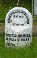 view gallery view gallery SW2.4 km SW2.4 km
| Milestone - Aberford Road, Sturton, Yorkshire, UK. in Milestones This milestone may have been re-sited a short way from it's original position. posted by: HitchinLookers location: Yorkshire, United Kingdom date approved: 06/27/2012 last visited: never |
 view gallery view gallery E2.7 km E2.7 km
| Lead Hall Farm Bridge - Saxton, UK in Stone Bridges This double arched stone bridge crosses a small stream and looks oversized for the size of the stream. posted by: dtrebilc location: Yorkshire, United Kingdom date approved: 04/02/2021 last visited: never |
 view gallery view galleryE2.7 km | Lead Hall Farm Bridge - Saxton, UK in Arch Bridges This double arched stone bridge crosses a small stream and looks oversized for the size of the stream. posted by: dtrebilc location: Yorkshire, United Kingdom date approved: 04/03/2021 last visited: never |
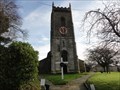
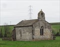 view gallery view galleryE2.9 km |  St. Mary's Chapel - Lead, UK St. Mary's Chapel - Lead, UK
in Wikipedia Entries St Mary's Church, Lead, is a redundant Anglican chapel standing in an isolated position in fields some 0.75 miles (1.2 km) to the west of the village of Saxton, North Yorkshire, England. posted by: dtrebilc location: Yorkshire, United Kingdom date approved: 04/02/2021 last visited: never |
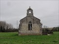 view gallery view galleryE2.9 km |  St. Mary's Chapel - Lead, UK St. Mary's Chapel - Lead, UK
in This Old Church St Mary's Church, Lead, is a redundant Anglican chapel standing in an isolated position in fields some 0.75 miles (1.2 km) to the west of the village of Saxton, North Yorkshire, England. posted by: dtrebilc location: Yorkshire, United Kingdom date approved: 04/01/2021 last visited: never |
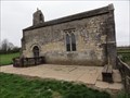 view gallery view galleryE2.9 km |  St. Mary's Chapel - Lead, UK St. Mary's Chapel - Lead, UK
in Medieval Churches St Mary's Church, Lead, is a redundant Anglican chapel standing in an isolated position in fields some 0.75 miles (1.2 km) to the west of the village of Saxton, North Yorkshire, England. posted by: dtrebilc location: Yorkshire, United Kingdom date approved: 04/01/2021 last visited: never |
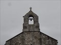 view gallery view galleryE2.9 km |  St. Mary's Chapel Bell Cote - Lead, UK St. Mary's Chapel Bell Cote - Lead, UK
in Bell Towers This bell cote is on top of a redundant chapel in the former manorial village of Lead. posted by: dtrebilc location: Yorkshire, United Kingdom date approved: 04/05/2021 last visited: never |
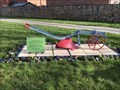 view gallery view gallery S2.9 km S2.9 km
|  Horse Drawn Plough - Micklefield, UK Horse Drawn Plough - Micklefield, UK
in Old Agricultural Equipment This horse drawn plough in a small grassed area in the centre of the village has a plaque with some information. posted by: dtrebilc location: Yorkshire, United Kingdom date approved: 03/03/2021 last visited: never |
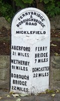 view gallery view galleryS2.9 km | Milestone - Great North Road, Micklefield, Yorkshire, UK. in Milestones This milestone is well looked after and has pride of place in a roadside garden. posted by: HitchinLookers location: Yorkshire, United Kingdom date approved: 10/09/2011 last visited: 02/27/2021 |
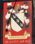 view gallery view galleryS3.2 km | The Blands Arms - Micklefield, UK in Pictorial Pub Signs This pub sign in the small village of Micklefield shows the coat of arms of the Blands family, Lords of the Manor from 1600 to the 1920s and sole landowners in Micklefield from 1750 to 1830. posted by: dtrebilc location: Yorkshire, United Kingdom date approved: 04/24/2021 last visited: never |
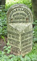 view gallery view galleryS3.4 km | Milestone - Ridge Road, Micklefield, Yorkshire, UK. in Milestones Away from the road and surrounded by trees. posted by: HitchinLookers location: Yorkshire, United Kingdom date approved: 06/28/2012 last visited: 01/07/2017 |
 view gallery view gallerySW3.5 km |  Quirky Craft Ales - Garforth, UK Quirky Craft Ales - Garforth, UK
in Brewpubs This brew pub is in a small industrial unit off Ash Lane, within walking distance of Garforth Town Centre. posted by: dtrebilc location: Yorkshire, United Kingdom date approved: 02/26/2023 last visited: never |
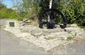 view gallery view galleryS3.7 km |  The Mining Community - Micklefield, UK The Mining Community - Micklefield, UK
in Citizen Memorials This commemorative stone and winding wheel are dedicated to the mining community that worked in Peckfield Colliery between 1876 and 1981. posted by: dtrebilc location: Yorkshire, United Kingdom date approved: 04/24/2021 last visited: never |
 view gallery view galleryW3.7 km | All Saints Church - Barwick In Elmet, UK in Medieval Churches Parts of this church date back to the 14th Century. posted by: dtrebilc location: Yorkshire, United Kingdom date approved: 12/10/2020 last visited: never |
 view gallery view galleryW3.7 km | All Saints Church - Barwick In Elmet, UK in This Old Church Parts of this Anglican church date back to the 14th Century. posted by: dtrebilc location: Yorkshire, United Kingdom date approved: 12/10/2020 last visited: never |
|