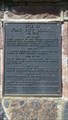
 view gallery view gallery SE16.1 km SE16.1 km
|   Fort Pitt School Fort Pitt School
in Saskatchewan Historical Markers Site of Fort Pitt School located Northeast of Provincial Historical Site. posted by:  Altima Voyageur Altima Voyageur location: Saskatchewan, Canada date approved: 09/16/2017 last visited: never |
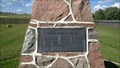 view gallery view gallery S17.5 km S17.5 km
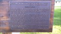
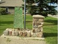
| R. H. Hougham in Saskatchewan Historical Markers Located inside the Fort Pit historical site is a cairn describing God's Half Acre. posted by: Altima Voyageur location: Saskatchewan, Canada date approved: 09/16/2017 last visited: never |
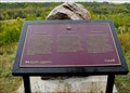
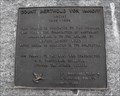
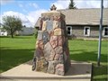
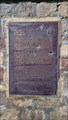 view gallery view galleryS17.9 km | Big Bear in Saskatchewan Historical Markers This is located on the back side of the Fort
Pitt Historical Cairn at Fort Pitt. posted by: Altima Voyageur location: Saskatchewan, Canada date approved: 09/16/2017 last visited: never |
 view gallery view galleryS17.9 km |  NHP Big Bear NHP Big Bear
in Canadian National Historic Sites This national historic person, is located on the back side of the Fort Pitt National Site cairn at the Fort Pitt Provincial Historic Site. posted by: Altima Voyageur location: Saskatchewan, Canada date approved: 10/05/2017 last visited: never |
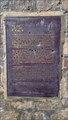
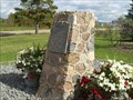
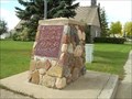
 view gallery view galleryS17.9 km | CNHS Fort Pitt in Canadian National Historic Sites West of French Butte. Big Bear Monument is on other side of cairn. posted by: Altima Voyageur location: Saskatchewan, Canada date approved: 09/21/2017 last visited: never |
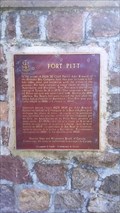
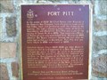 view gallery view galleryS17.9 km | Fort Pitt in Saskatchewan Historical Markers Fort Pitt Provincial Historic Park, west of Paradise Hill near the Alberta border. posted by: Altima Voyageur location: Saskatchewan, Canada date approved: 09/22/2009 last visited: never |
 view gallery view gallerySE23.3 km | CNHS Frenchman Butte in Canadian National Historic Sites Located north of the small community of Frenchman Butte. posted by: Altima Voyageur location: Saskatchewan, Canada date approved: 11/19/2017 last visited: never |
 view gallery view gallerySE23.3 km | Frenchman Butte National Historic Site in Saskatchewan Historical Markers Located North of the community of Frenchman Butte. posted by: Altima Voyageur location: Saskatchewan, Canada date approved: 10/09/2013 last visited: never |
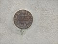 view gallery view gallery E46.3 km E46.3 km
|  866-F (Geodetic Survey of Canada) - St Walburg, SK 866-F (Geodetic Survey of Canada) - St Walburg, SK
in Canadian Benchmarks Benchmark on the wall of the post office posted by: Bon Echo location: Saskatchewan, Canada date approved: 11/14/2015 last visited: never |
 view gallery view galleryE46.3 km | Trotzuk Millstone in Saskatchewan Historical Markers Located in front of the St. Walburg Museum at the end of Main Street. posted by: Altima Voyageur location: Saskatchewan, Canada date approved: 09/16/2017 last visited: never |
 view gallery view galleryS46.5 km | Barr Colony Campsite in Saskatchewan Historical Markers Barr Colony Campsite just a short distance north on the skirt of the city. Inside the Saskatchewan side of Lloydminster. posted by: Altima Voyageur location: Saskatchewan, Canada date approved: 09/28/2010 last visited: 02/22/2014 |
 view gallery view galleryE46.7 km | Count Berthold Von Imhoff in Saskatchewan Historical Markers Located in St. Walburg. posted by: Altima Voyageur location: Saskatchewan, Canada date approved: 10/09/2013 last visited: never |
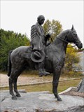 view gallery view galleryE46.7 km |  Count Berthold Von Imhoff Count Berthold Von Imhoff
in Equestrian Statues Located in small community of St. Walburg, Saskatchewan posted by: Altima Voyageur location: Saskatchewan, Canada date approved: 11/28/2017 last visited: never |
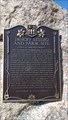 view gallery view galleryE47.5 km | Imhoff Studio and Farm Site in Saskatchewan Historical Markers Located outside of St Walburg, Saskatchewan posted by: Altima Voyageur location: Saskatchewan, Canada date approved: 09/16/2017 last visited: never |
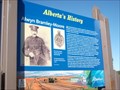
 view gallery view galleryS49.6 km | George Exton Lloyd National Historic Monument in Saskatchewan Historical Markers George Exton Lloyd an Anglican missionary and teacher, Chaplain onwards to become Principal and onto Bishop of Saskatchewan. posted by: Altima Voyageur location: Saskatchewan, Canada date approved: 09/28/2010 last visited: 08/28/2018 |
 view gallery view galleryS49.6 km | One mile marker in Saskatchewan Historical Markers This waymark is located in the same vicinity of the three other plaques. posted by: Altima Voyageur location: Saskatchewan, Canada date approved: 09/28/2010 last visited: 02/22/2014 |
 view gallery view galleryS49.6 km | Oil and Gas in Saskatchewan Historical Markers Oil and Gas Discoveries, located in the middle of two other cairns. Enjoy posted by: Altima Voyageur location: Saskatchewan, Canada date approved: 09/28/2010 last visited: 02/22/2014 |
 view gallery view galleryS49.6 km | St. John's in Saskatchewan Historical Markers A few steps away this marker is located on the the old church. posted by: Altima Voyageur location: Saskatchewan, Canada date approved: 09/29/2010 last visited: 12/25/2013 |
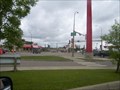 view gallery view galleryS49.6 km |  Saskatchewan / Alberta Provincial Border crossing #1 Saskatchewan / Alberta Provincial Border crossing #1
in Border Crossings One of the view borders anywhere that actually cuts a town in half - that of the town of Lloydminster. posted by: StagsRoar location: Saskatchewan, Canada date approved: 05/27/2006 last visited: 08/29/2018 |
 view gallery view gallery SW51.5 km SW51.5 km
|  Alwyn Bramley-Moore Alwyn Bramley-Moore
in Alberta Heritage Markers Alwyn Bramley-Moore on Hwy 16, east of Kitscoty, Ab posted by:  yellowmojo yellowmojo location: Alberta, Canada date approved: 08/30/2011 last visited: 12/24/2013 |
 view gallery view gallery NE51.8 km NE51.8 km
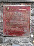
| CNHS Steele Narrows in Canadian National Historic Sites Located South of Makwa Lake, East of Village of Loon Lake, on Hwy 699. This national monument is located at Steele Narrows Provincial Park. posted by: Altima Voyageur location: Saskatchewan, Canada date approved: 11/19/2017 last visited: never |
 view gallery view galleryNE51.8 km | Steele Narrows National Historic Monument in Saskatchewan Historical Markers Located South of Makwa Lake, East of Village of Loon Lake, on Hwy 699. This national monument is located at Steele Narrows Provincial Park. posted by: Altima Voyageur location: Saskatchewan, Canada date approved: 09/29/2011 last visited: 07/02/2015 |
 view gallery view galleryS51.8 km |  Buffalo Twins - Lloydminster, AB Buffalo Twins - Lloydminster, AB
in Murals Here is a huge mural that totally blew us away. In the area of Lloydminster, AB/SK, this is an absolute must see. posted by: T0SHEA location: Alberta, Canada date approved: 12/29/2012 last visited: 02/12/2014 |
 view gallery view galleryS51.8 km |  Buffalo Twins - Lloydminster, AB Buffalo Twins - Lloydminster, AB
in Mosaics Here is a huge mosaic that totally blew us away. In the area of Lloydminster, AB/SK, this is an absolute must see. posted by: T0SHEA location: Alberta, Canada date approved: 12/29/2012 last visited: 02/13/2014 |
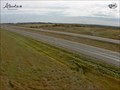 view gallery view gallerySW52 km |  Lloydminster Traffic Webcam - Lloydminster, AB Lloydminster Traffic Webcam - Lloydminster, AB
in Web Cameras Hiway 16, Near Lloydminster and East of Hiway 897. posted by: T0SHEA location: Alberta, Canada date approved: 11/06/2013 last visited: 05/26/2014 |
|