 view gallery view gallery W4 km W4 km
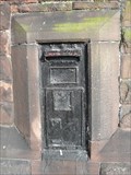
|   Disused Victorian box at Gateacre, Liverpool Disused Victorian box at Gateacre, Liverpool
in Victorian Post Boxes A wall mounted box at the junction of Gateacre Brow and Rose Brow posted by:  John Stead John Stead location: North West England, United Kingdom date approved: 10/27/2009 last visited: 10/27/2009 |
 view gallery view gallery SE4.5 km SE4.5 km
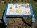
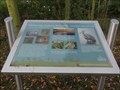
|  Wetland Plants Survive Here - Halebank, UK Wetland Plants Survive Here - Halebank, UK
in Flora and Fauna Information Signs This low information board is in the north east corner of Pickering Pastures local nature reserve and has information about rare wetland plants that survive here. posted by:  dtrebilc dtrebilc location: North West England, United Kingdom date approved: 10/17/2016 last visited: never |
 view gallery view gallerySE4.5 km | Cornfield Meadow - Halebank, UK in Flora and Fauna Information Signs This information board stands at the entrance near to the car park of Pickerings Pasture nature reserve. posted by: dtrebilc location: North West England, United Kingdom date approved: 10/17/2016 last visited: never |
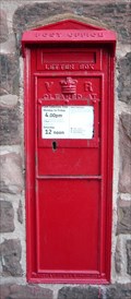
 view gallery view gallery N4.7 km N4.7 km
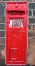
| Prescot Railway Station in Victorian Post Boxes A wall box in the car park side of the station building posted by: John Stead location: North West England, United Kingdom date approved: 02/24/2010 last visited: 02/22/2010 |
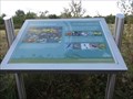
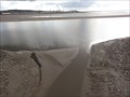
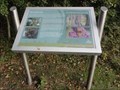
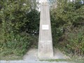 view gallery view gallerySE4.7 km |  Site Of Navigation Marker - Ditton Marsh, UK Site Of Navigation Marker - Ditton Marsh, UK
in Obelisks This obelisk was erected as part of a land reclamation scheme and marks the site of a former navigation beacon on the banks of the River Mersey. posted by: dtrebilc location: North West England, United Kingdom date approved: 10/15/2016 last visited: never |
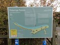
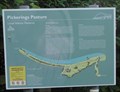 view gallery view gallerySE4.7 km | Pickerings Pasture (Eastern Entrance) - Ditton Marsh, UK in Flora and Fauna Information Signs This map and information board stands at the eastern entrance to Pickerings Pasture on the Trans Pennine Trail. posted by: dtrebilc location: North West England, United Kingdom date approved: 10/17/2016 last visited: never |
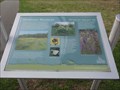
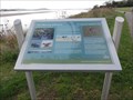 view gallery view gallerySE4.7 km | The Mersey Estuary - Halebank, UK in Flora and Fauna Information Signs This information board stands on the north bank of the River Mersey alongside the Trans Pennine Trail in the middle of the nature reserve called Pickering's Pasture.. posted by: dtrebilc location: North West England, United Kingdom date approved: 10/17/2016 last visited: never |
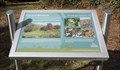 view gallery view gallerySE4.7 km | Control Meadow - Halebank, UK in Flora and Fauna Information Signs This information board is in the Pickering Pastures local nature reserve and has information about plants and wild life in a control meadow on the site. posted by: dtrebilc location: North West England, United Kingdom date approved: 10/17/2016 last visited: never |
 view gallery view gallerySE4.7 km |  CONFLUENCE - Ditton Brook, River Mersey - Ditton Marsh, UK CONFLUENCE - Ditton Brook, River Mersey - Ditton Marsh, UK
in River Origins, Destinations and Confluences This spot marks the confluence of Ditton Brook and The River Mersey and is crossed by a foot / cycle bridge over the brook. posted by: dtrebilc location: North West England, United Kingdom date approved: 10/16/2016 last visited: never |
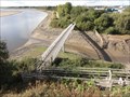 view gallery view gallerySE4.7 km |  Trans Pennine Trail Bridge - Ditton Marsh, UK Trans Pennine Trail Bridge - Ditton Marsh, UK
in Hiking Path Footbridges This metal foot / cycle bridge carries the Trans Pennine Trail over Ditton Brook at its confluence with the River Mersey. posted by: dtrebilc location: North West England, United Kingdom date approved: 10/17/2016 last visited: never |
 view gallery view gallery S4.8 km S4.8 km
| Pickerings Pasture (North Western Entrance) - Hale Bank, UK in Flora and Fauna Information Signs This map and information board stands at the western entrance to Pickerings Pasture on the Trans Pennine Trail. posted by: dtrebilc location: North West England, United Kingdom date approved: 10/17/2016 last visited: never |
 view gallery view gallerySE4.8 km | Wildflower Meadows - Halebank, UK in Flora and Fauna Information Signs This information board is in the Pickering Pastures local nature reserve and has information about plants in various wild flower meadows on the site. posted by: dtrebilc location: North West England, United Kingdom date approved: 10/17/2016 last visited: never |
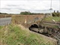 view gallery view galleryS4.8 km |  Marsh Bridge - Hale, UK Marsh Bridge - Hale, UK
in Arch Bridges This single arch bridge carries a minor road over Ram's Brook. posted by: dtrebilc location: North West England, United Kingdom date approved: 10/17/2016 last visited: never |
 view gallery view gallerySE4.8 km | Woodlands - Halebank, UK in Flora and Fauna Information Signs This information board is in the Pickering Pastures local nature reserve and has information about plants and wild life in the woodlands at the western edge of the site. posted by: dtrebilc location: North West England, United Kingdom date approved: 10/17/2016 last visited: never |
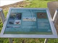
 view gallery view gallerySE5 km | Pickerings Pasture Bird Hide - Halebank, UK in Flora and Fauna Information Signs This information board is on the western edge of Pickering Pastures local nature reserve and has information about birds and other wild life that can be seen on Hale Marsh next to this site. posted by: dtrebilc location: North West England, United Kingdom date approved: 10/17/2016 last visited: never |
 view gallery view gallerySE5 km | The Mersey Estuary - Halebank, UK in Flora and Fauna Information Signs This information board stands on the north bank of the River Mersey alongside the Trans Pennine Trail, at the south western edge of the nature reserve called Pickering's Pasture. posted by: dtrebilc location: North West England, United Kingdom date approved: 10/17/2016 last visited: never |
 view gallery view galleryW5.1 km |  John Lennon Blue Plaque John Lennon Blue Plaque
in Beatlemania! The Blue Plaque is displayed on the wall of 251 Menlove Avenue, named Mendips, which was the childhood home of John Lennon, singer and songwriter with The Beatles, and is now preserved by the National Trust. posted by:  Sparks68 Sparks68 location: North West England, United Kingdom date approved: 01/17/2010 last visited: never |
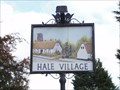 view gallery view galleryS5.1 km |  Hale - Halton, UK Hale - Halton, UK
in Pictorial Village Signs This village sign was erected on the village green in the year 2000. posted by: dtrebilc location: North West England, United Kingdom date approved: 10/26/2016 last visited: 09/06/2017 |
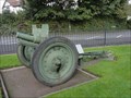 view gallery view galleryS5.3 km |  Captured Russian Anti-Tank Gun - Hale, UK Captured Russian Anti-Tank Gun - Hale, UK
in Static Artillery Displays This artillery piece stands next to a combined World War I and World War II memorial on the village green posted by: dtrebilc location: United Kingdom date approved: 10/16/2016 last visited: never |
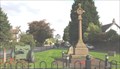 view gallery view galleryS5.3 km |  Combined World Wars Memorial, Hale, UK Combined World Wars Memorial, Hale, UK
in World War I Memorials and Monuments This stone cross was erected to commemorate the First World War. It has subsequently been expanded to include a group of memorials commemorating both World Wars. posted by: dtrebilc location: North West England, United Kingdom date approved: 10/17/2016 last visited: never |
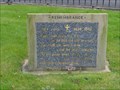 view gallery view galleryS5.3 km |  World War I Poems - Hale, UK World War I Poems - Hale, UK
in Etched in Stone In 2004 two commemorative tablets were added to the combined World War I and World War II monument in the village of Hale. posted by: dtrebilc location: North West England, United Kingdom date approved: 10/21/2016 last visited: never |
 view gallery view galleryW5.3 km | Childwall Abbey, Liverpool in Victorian Post Boxes Box mounted in the wall of the Childwall Abbey Hotel in suburban Liverpool posted by: John Stead location: United Kingdom date approved: 10/26/2009 last visited: 10/26/2009 |
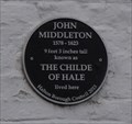 view gallery view galleryS5.3 km |  John Middleton Black Plaque- Hale, UK John Middleton Black Plaque- Hale, UK
in Blue Plaques This plaque on the gable end of a thatched cottage marks the home of John Middleton, 'The Childe of Hale', a giant of 9 feet 3 inches. posted by: dtrebilc location: North West England, United Kingdom date approved: 10/14/2016 last visited: never |
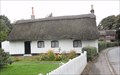 view gallery view galleryS5.3 km |  John Middleton's Cottage - Hale, UK John Middleton's Cottage - Hale, UK
in Thatch Cottages This thatched cottage in the village of Hale was the the home of local giant, reputed to be 9 feet 3 inches tall, and who lived between 1578 and 1623. posted by: dtrebilc location: North West England, United Kingdom date approved: 10/22/2016 last visited: never |
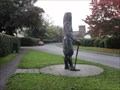 view gallery view galleryS5.5 km |  John Middleton, The Childe of Hale - Hale, UK John Middleton, The Childe of Hale - Hale, UK
in Roadside Attractions This statue is of local man John Middleton, 'The Childe of Hale', a giant of 9 feet 3 inches. It stands at the side of Church Road and is accessible 24/7. posted by: dtrebilc location: North West England, United Kingdom date approved: 10/21/2016 last visited: never |
|