 view gallery view gallery NW3.9 km NW3.9 km
|   Llandudno Pier - Satellite Oddity - Llandudno, Conwy, North Wales, Llandudno Pier - Satellite Oddity - Llandudno, Conwy, North Wales,
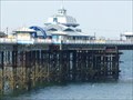
in Satellite Imagery Oddities Llandudno Pier built in 1877 at 2,295 feet is the longest pier in Wales. Located in the seaside resort of Llandudno on the coast of North Wales. posted by:  veritas vita veritas vita location: North Wales, United Kingdom date approved: 10/20/2013 last visited: 07/26/2013 |
 view gallery view galleryNW3.9 km |  The North Wales Inn, Rhyl, Denbighshire, Wales The North Wales Inn, Rhyl, Denbighshire, Wales
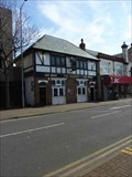
in Pubs and Inns The North Wales Inn, 27 Wellington Road, Rhyl (also known as "The North". posted by: The_Senior_Crabbes location: North Wales, United Kingdom date approved: 06/25/2019 last visited: never |
 view gallery view gallery SW5.6 km SW5.6 km
|  Black Park Colliery, Chirk, Wrexham, Wales, UK Black Park Colliery, Chirk, Wrexham, Wales, UK
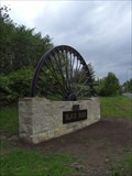
in UK Historical Markers A historical marker to the Black Park Colliery that was located on this site from 1863 to 1969. posted by: Ddraig Ddu location: North Wales, United Kingdom date approved: 05/10/2011 last visited: never |
 view gallery view gallery W6.4 km W6.4 km
|  Pentre WW1 & WW2 Memorial - Wrexham, Wales, UK Pentre WW1 & WW2 Memorial - Wrexham, Wales, UK
in Non-Specific Veteran Memorials A war memorial to those in Pentre who gave their lives in the first and second world wars. posted by: Ddraig Ddu location: North Wales, United Kingdom date approved: 08/04/2013 last visited: never |
 view gallery view galleryNW6.4 km |  Dovecote, Erddig Estate, Wrexham, Wales, UK Dovecote, Erddig Estate, Wrexham, Wales, UK
in Octagon Buildings A dovecote in the Erddig estate just south of Wrexham. posted by: Ddraig Ddu location: North Wales, United Kingdom date approved: 07/04/2011 last visited: never |
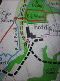 view gallery view galleryNW6.6 km |  Sign, Drink Area, Erddig Estate, Wrexham, Wales, UK Sign, Drink Area, Erddig Estate, Wrexham, Wales, UK
in 'You Are Here' Maps A sign near a drinks area on the Erddig estate, a great circular walk. posted by: Ddraig Ddu location: North Wales, United Kingdom date approved: 07/18/2011 last visited: never |
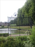 view gallery view gallery N6.6 km N6.6 km
|  Stansty Main Gates - Erddig Estate, Wrexham, Wales, UK Stansty Main Gates - Erddig Estate, Wrexham, Wales, UK
in Gates of Distinction A set of beautiful gates at the east end of the the garden grounds to the front of the building. posted by: Ddraig Ddu location: North Wales, United Kingdom date approved: 07/08/2011 last visited: never |
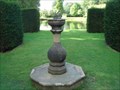 view gallery view galleryN6.6 km |  Erddig House (2), Wrexham, Wales, UK Erddig House (2), Wrexham, Wales, UK
in Sundials Second of 2 sundials in the grounds of Erddig House National Trust property in Wales. This one is at the end of the lake behind the house. posted by: GeoRams location: United Kingdom date approved: 08/26/2006 last visited: 04/14/2012 |
 view gallery view galleryNW6.8 km | Erddig House (1), Wrexham, Wales, UK in Sundials One of 2 sundials in the grounds of Erddig House National Trust property in Wales.
This one is directly behind the house. posted by: GeoRams location: United Kingdom date approved: 08/26/2006 last visited: 04/14/2012 |
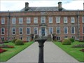
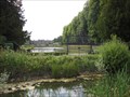
 view gallery view galleryNW6.8 km |  Erddig Manor & Gardens, Erddig Estate, Wrexham, Wales, UK Erddig Manor & Gardens, Erddig Estate, Wrexham, Wales, UK
in National Trust U.K. Erddig house is a 18thC house set in a series of magnificent gardens is now after 250 years in a family's hands, is now under the control of the National Trust. posted by: Ddraig Ddu location: North Wales, United Kingdom date approved: 07/05/2011 last visited: 04/11/2014 |
 view gallery view galleryNW6.8 km |  Erddig Manor & Gardens, Erddig Estate, Wrexham, Wales, UK Erddig Manor & Gardens, Erddig Estate, Wrexham, Wales, UK
in Wikipedia Entries Erddig house is a 18thC house set in a series of magnificent gardens is now after 250 years in a family's hands, is now under the control of the National Trust. posted by: Ddraig Ddu location: North Wales, United Kingdom date approved: 09/27/2011 last visited: never |
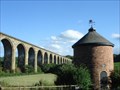
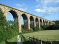 view gallery view galleryW6.8 km |  Cefn Mawr Viaduct - River Dee, Wales, U.K. Cefn Mawr Viaduct - River Dee, Wales, U.K.
in Railroad Bridges The Cefn Mawr sandstone Viaduct, built by Thomas Brassey in 1848 to carry the Shrewsbury and Chester railway across the valley of the River Dee. posted by: GeoRams location: United Kingdom date approved: 09/02/2006 last visited: 06/27/2017 |
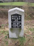 view gallery view galleryW6.9 km |  Milestone, Holyhead Road, Chirk, Wrexham, Wales, UK Milestone, Holyhead Road, Chirk, Wrexham, Wales, UK
in Milestones A milestone on the south side of the Holyhead road, or A5 as its more commonly known, showing the local distances. posted by: Ddraig Ddu location: North Wales, United Kingdom date approved: 02/07/2013 last visited: never |
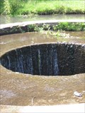 view gallery view galleryNW6.9 km |  Waterfall, Erddig Estate, Wrexham, Wales, UK Waterfall, Erddig Estate, Wrexham, Wales, UK
in Man-made Waterfalls A manmade hole that works as a waterfall to capture water for a Hydralic Ram in use from 1822 to 1926. posted by: Ddraig Ddu location: North Wales, United Kingdom date approved: 07/25/2011 last visited: never |
 view gallery view galleryW6.9 km |  Welsh Dragon - Ty Mawr Country Park, Wales, U.K. Welsh Dragon - Ty Mawr Country Park, Wales, U.K.
in Unique Weathervanes Welsh Dragon Weathervane atop a dovecote. This is a memorial to a Royal Welch Fusilier. posted by: GeoRams location: United Kingdom date approved: 09/02/2006 last visited: 08/24/2006 |
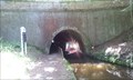 view gallery view galleryW6.9 km |  Whitehouse Tunnel, Chirk, Wrexham, Wales, UK Whitehouse Tunnel, Chirk, Wrexham, Wales, UK
in Canal Tunnels The Whitehouse tunnel is the shorter cousin of the canal tunnel to the south, it stretches 174 meters and allows two way traffic. posted by: Ddraig Ddu location: North Wales, United Kingdom date approved: 07/29/2013 last visited: 10/18/2015 |
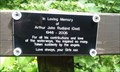 view gallery view galleryW6.9 km |  Arthur John Rudland, Whitehouse Tunnel, Chirk, Wrexham, Wales, UK Arthur John Rudland, Whitehouse Tunnel, Chirk, Wrexham, Wales, UK
in Dedicated Benches A dedicated bench on the south entrance to the Whitehouse canal tunnel to the memory of Arthur John Rudland. posted by: Ddraig Ddu location: North Wales, United Kingdom date approved: 07/29/2013 last visited: never |
 view gallery view galleryW7.1 km | Bridge, Plas Kynaston Lane, Acrefair, Wrexham, Wales, UK in Railroad Bridges A railway bridge that crosses the Plas Kynaston Lane just outside of Acrefair to the east of Trevor. posted by: Ddraig Ddu location: North Wales, United Kingdom date approved: 08/04/2013 last visited: never |
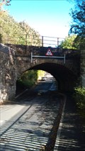 view gallery view galleryW7.1 km |  Bridge, Plas Kynaston Lane, Acrefair, Wrexham, Wales, UK Bridge, Plas Kynaston Lane, Acrefair, Wrexham, Wales, UK
in Arch Bridges A railway bridge that crosses the Plas Kynaston Lane just outside of Acrefair to the east of Trevor. posted by: Ddraig Ddu location: North Wales, United Kingdom date approved: 08/04/2013 last visited: never |
 view gallery view galleryW7.1 km |  Bridge, Plas Kynaston Lane, Acrefair, Wrexham, Wales, UK Bridge, Plas Kynaston Lane, Acrefair, Wrexham, Wales, UK
in Stone Bridges A railway bridge that crosses the Plas Kynaston Lane just outside of Acrefair to the east of Trevor. posted by: Ddraig Ddu location: North Wales, United Kingdom date approved: 08/04/2013 last visited: never |
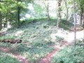 view gallery view galleryN7.1 km |  Erddig Motte & Bailey Castle, Erddig Estate, Wrexham, Wales, UK Erddig Motte & Bailey Castle, Erddig Estate, Wrexham, Wales, UK
in English Heritage - Cadw - Historic Scotland A ruined Motte & Bailey castle protected by CADW on the Erddig estate. The shape of the distinct terrain remains to this day, and is all that can still be seen of the wooden construction. posted by: Ddraig Ddu location: North Wales, United Kingdom date approved: 07/05/2011 last visited: never |
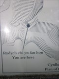 view gallery view galleryN7.1 km | Sign, Motte and Bailey, Erddig Estate, Wrexham, Wales, UK in 'You Are Here' Maps A sign at the center of a Motte and Bailey remnant on the Erddig estate. posted by: Ddraig Ddu location: North Wales, United Kingdom date approved: 07/04/2011 last visited: never |
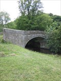 view gallery view galleryN7.1 km | Erddig Bridge, Erddig Estate, Wrexham, Wales, UK in Stone Bridges A bridge on the Erddig estate that was once used as the road to enter the estate, now only used for odd estate traffic around the Cadw estate. posted by: Ddraig Ddu location: North Wales, United Kingdom date approved: 07/04/2011 last visited: never |
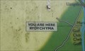 view gallery view galleryW7.2 km | Sign, Chirk Marina, Chirk, Wrexham, Wales, UK in 'You Are Here' Maps A sign showing your position with respect to the Chirk marina and the local area. posted by: Ddraig Ddu location: North Wales, United Kingdom date approved: 07/29/2013 last visited: never |
 view gallery view gallerySW7.2 km |  Chirk, United Methodist Church Chirk, United Methodist Church
in U.K. and Ireland Trigpoints Cut mark: On NE angle of United Methodist Church on Chapel Lane, Chirk, Wrexham. posted by: Meirion location: North Wales, United Kingdom date approved: 01/26/2010 last visited: never |
|