 view gallery view gallery SW3.7 km SW3.7 km
|   Moel Y Golfa Moel Y Golfa
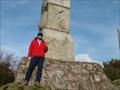
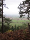
in Mountain Summits Moel Y Golfa (GW/MW-027) The highest point of a fine little group of hills to the west of Shrewsbury. On the summit there is a massive memorial monument. posted by:  charlieg0pzo charlieg0pzo location: United Kingdom date approved: 10/08/2006 last visited: 05/23/2010 |
 view gallery view gallery NE8 km NE8 km
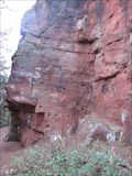
|  Nesscliffe Cliff Faces, Iron Age Hill Fort, Nesscliffe, Shrewsbury, Shropshire, England, UK Nesscliffe Cliff Faces, Iron Age Hill Fort, Nesscliffe, Shrewsbury, Shropshire, England, UK
in Established Rock Climbing Areas Nesscliffe has a series of cliff faces running north-south and formed part of the Iron age hill fort as a natural defence. posted by:  Ddraig Ddu Ddraig Ddu location: West Midlands, United Kingdom date approved: 11/21/2011 last visited: never |
 view gallery view galleryNE8 km |  Humphrey Kynaston, Nesscliffe Cave, Nesscliffe, Shropshire, England, UK Humphrey Kynaston, Nesscliffe Cave, Nesscliffe, Shropshire, England, UK
in Infamous Crime Scenes A local highwayman that some believe gave robin hood some of his myth by his action. This is the place that holds his history on the run and while he worked as a highwayman. Here was the location where he planned his attacks and hid from capture. posted by: Ddraig Ddu location: West Midlands, United Kingdom date approved: 11/21/2011 last visited: never |
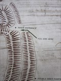
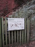 view gallery view galleryNE8 km |  Kynastons Cave, Cliffs, Nesscliffe, Shrewsbury, Shropshire, England, UK Kynastons Cave, Cliffs, Nesscliffe, Shrewsbury, Shropshire, England, UK
in Signs of History A sign with he history of the nearby Kynaston Cave on it. A cave entrance caved to look like a door and window which was home to 'Wild Humphrey' who was a fugitive and highwaysman in the 16th Century. posted by: Ddraig Ddu location: West Midlands, United Kingdom date approved: 11/21/2011 last visited: never |
 view gallery view galleryNE8 km | ") Kynastons Cave, Cliffs, Nesscliffe, Shrewsbury, Shropshire, England, UK Kynastons Cave, Cliffs, Nesscliffe, Shrewsbury, Shropshire, England, UK
in Cave Entrances (Artificial) A cave entrance caved to look like a door and window which was home to 'Wild Humphrey' who was a fugitive and highwaysman in the 16th Century. posted by: Ddraig Ddu location: West Midlands, United Kingdom date approved: 11/22/2011 last visited: never |
 view gallery view galleryNE8 km |  Nesscliffe, Shrewsbury, Shropshire, England, UK Nesscliffe, Shrewsbury, Shropshire, England, UK
in Wikipedia Entries A small village with a long standing history back to the Iron age on the Welsh-English border. posted by: Ddraig Ddu location: West Midlands, United Kingdom date approved: 11/21/2011 last visited: never |
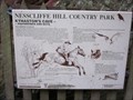
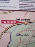
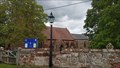
 view gallery view galleryNE8.2 km |  Sign, Nesscliffe Hill Fort, Nesscliffe, Shropshire, England, UK Sign, Nesscliffe Hill Fort, Nesscliffe, Shropshire, England, UK
in 'You Are Here' Maps A sign on the top of the old iron age hill fort that shows your location within the area of the woods. posted by: Ddraig Ddu location: West Midlands, United Kingdom date approved: 11/21/2011 last visited: never |
 view gallery view galleryNE8.4 km | Sign, Nesscliffe, Shrewsbury, Shropshire, England, UK in 'You Are Here' Maps A sign showing the walks around the local woods and former iron age hill fort. posted by: Ddraig Ddu location: West Midlands, United Kingdom date approved: 11/21/2011 last visited: never |
 view gallery view gallery NW8.7 km NW8.7 km
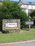
|  Wales/England, A483, UK Wales/England, A483, UK
in Border Crossings A border crossing with nothing to stop you entering Wales or England. Although this is the current border, the wars over the line that separated Wales and England was under dispute for many years in history. posted by: Ddraig Ddu location: North Wales, United Kingdom date approved: 07/05/2011 last visited: never |
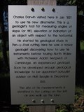 view gallery view galleryNW8.7 km |  Charles Darwin, Llanymynech, Powys, Wales, UK Charles Darwin, Llanymynech, Powys, Wales, UK
in UK Historical Markers A plaque showing that Charles Darwin came to this spot in July 1831. posted by: Ddraig Ddu location: North Wales, United Kingdom date approved: 07/04/2011 last visited: never |
 view gallery view galleryNE8.7 km |  St Andrew's church - Great Ness, Shropshire St Andrew's church - Great Ness, Shropshire
in Anglican and Episcopal Churches St Andrew's church, Great Ness. An active Anglican parish church in the deanery of Ellesmere, the archdeaconry of Salop, and the diocese of Lichfield. posted by: SMacB location: West Midlands, United Kingdom date approved: 06/23/2019 last visited: never |
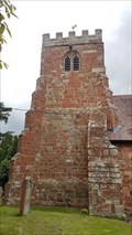 view gallery view galleryNE8.7 km |  Bell Tower - St Andrew - Great Ness, Shropshire Bell Tower - St Andrew - Great Ness, Shropshire
in Bell Towers Bell tower of St Andrew's church, Great Ness, with a ring of 6 bells. posted by: SMacB location: West Midlands, United Kingdom date approved: 06/23/2019 last visited: never |
 view gallery view galleryNE8.7 km | St Andrew's church - Great Ness, Shropshire, UK in Wikipedia Entries Parish church of St Andrew, Great Ness. posted by: SMacB location: West Midlands, United Kingdom date approved: 06/23/2019 last visited: never |
 view gallery view galleryNE8.7 km |  St Andrew - Great Ness, Shropshire St Andrew - Great Ness, Shropshire
in Medieval Churches 11th century church of St Andrew, Great Ness. An active Anglican parish church in the deanery of Ellesmere, the archdeaconry of Salop, and the diocese of Lichfield. posted by: SMacB location: West Midlands, United Kingdom date approved: 06/23/2019 last visited: never |
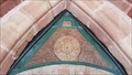 view gallery view galleryNE8.7 km |  Tudor Rose - St Andrew - Great Ness, Shropshire Tudor Rose - St Andrew - Great Ness, Shropshire
in Frieze Art Tudor rose carved over the south entrence to St Andrew's church, Great Ness. posted by: SMacB location: West Midlands, United Kingdom date approved: 06/23/2019 last visited: never |
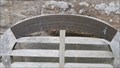 view gallery view galleryNE8.9 km |  Kathleen, Charles & Gerald Embrey - St Andrew - Great Ness, Shropshire Kathleen, Charles & Gerald Embrey - St Andrew - Great Ness, Shropshire
in Dedicated Benches Wooden bench dedicated to members of the Embrey family, Kathleen, Charles & Gerald, outside St Andrew's church, Great Ness. posted by: SMacB location: West Midlands, United Kingdom date approved: 06/23/2019 last visited: never |
 NW9.5 km |  Llanymynech Golf Links Llanymynech Golf Links
in U.K. and Ireland Trigpoints Located in Powys County posted by: Team Maddie UK location: United Kingdom date approved: 08/16/2005 last visited: never |
 view gallery view gallery N10.3 km N10.3 km
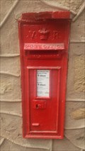
|  Victorian Post Box - Weirbrook, Shropshire Victorian Post Box - Weirbrook, Shropshire
in Victorian Post Boxes A Victorian letterbox incorporated into the aptly named 'Letterbox Cottage', Weirbrook, nr. West Felton. posted by: SMacB location: West Midlands, United Kingdom date approved: 07/02/2019 last visited: never |
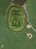 view gallery view gallerySW10.5 km |  Royal View, Hope, Leighton, Powys, Wales Royal View, Hope, Leighton, Powys, Wales
in Satellite Imagery Oddities An odd Royal nod to the raining monarch HRH Elisabeth the Second, found while viewing the local area for viable Geocache hunts, located near Hope in Leighton. posted by: Ddraig Ddu location: North Wales, United Kingdom date approved: 01/04/2011 last visited: never |
 view gallery view gallerySW10.5 km | Long Mountain-Beacon Ring in Mountain Summits This summit is in fact an Iron Age fort and the Trig. Point is in the middle of a wood surrouded by the walls of the fort. posted by: charlieg0pzo location: United Kingdom date approved: 08/23/2006 last visited: 10/10/2009 |
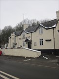 view gallery view galleryNW10.8 km |  The Lime Kiln, Porth-y-Waen, Oswestry, Shropshire, England, UK The Lime Kiln, Porth-y-Waen, Oswestry, Shropshire, England, UK
in Pubs and Inns The lime kiln is a privately owned public house and restaurant on the north side of the road in Porth-y-Waen, which beside its name is just on the English side of the Anglo-Welsh border. posted by: Ddraig Ddu location: West Midlands, United Kingdom date approved: 02/03/2013 last visited: never |
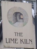 view gallery view galleryNW10.8 km |  The Lime Kiln, Porth-y-Waen, Oswestry, Shropshire, England, UK The Lime Kiln, Porth-y-Waen, Oswestry, Shropshire, England, UK
in Pictorial Pub Signs The lime kiln is a privately owned public house and restaurant on the north side of the road in Porth-y-Waen, which beside its name is just on the English side of the Anglo-Welsh border. The sign links to its name, showing a lime kiln. posted by: Ddraig Ddu location: West Midlands, United Kingdom date approved: 01/26/2013 last visited: never |
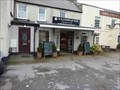 view gallery view galleryNE11.1 km |  N S James & Son, Raglan, Gwent, Wales N S James & Son, Raglan, Gwent, Wales
in Ye Olde Butcher Shoppe N S James & Son, Raglan posted by: The_Senior_Crabbes location: South Wales, United Kingdom date approved: 10/31/2016 last visited: never |
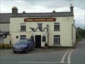 view gallery view galleryNE11.1 km | The Crown Inn, Raglan, Gwent, Wales in Pubs and Inns The Crown Inn, Raglan posted by: The_Senior_Crabbes location: South Wales, United Kingdom date approved: 10/29/2016 last visited: never |
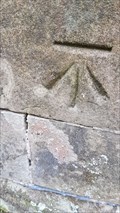 view gallery view galleryN11.1 km | Benchmark - Pradoe Church - Oswestry, Shropshire in U.K. and Ireland Trigpoints Cut benchmark on the south west corner of Pradoe church, Oswestry. posted by: SMacB location: West Midlands, United Kingdom date approved: 07/02/2019 last visited: never |
|