 view gallery view gallery N1.9 km N1.9 km
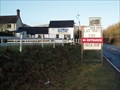
|   Lazy Trout - A49, Shropshire, UK Lazy Trout - A49, Shropshire, UK
in Truck Stops A popular vintage Truck Stop which has been open since 1937. posted by:  Superted Superted location: West Midlands, United Kingdom date approved: 01/25/2010 last visited: never |
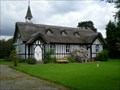 view gallery view galleryN3.1 km |  All Saints' Church, Little Stretton, Shropshire All Saints' Church, Little Stretton, Shropshire
in This Old Church All Saints’ Church is located in the centre of the village of Little Stretton. posted by: DesG location: United Kingdom date approved: 06/10/2009 last visited: 08/31/2017 |
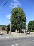
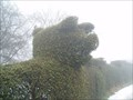 view gallery view galleryN3.9 km |  Pig and Piglets - Church Stretton, Shropshire, UK Pig and Piglets - Church Stretton, Shropshire, UK
in Topiaries A pig and piglets have been carved into the top of this hedge that borders Clemcroft Farm on the hill above the Shropshire town of Church Stretton. posted by: Superted location: West Midlands, United Kingdom date approved: 01/26/2010 last visited: 09/02/2012 |
 view gallery view gallery NE3.9 km NE3.9 km
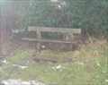
|  Ken & Jessie Evans - Church Stretton, Shropshire, UK Ken & Jessie Evans - Church Stretton, Shropshire, UK
in Dedicated Benches A wooden bench on a country lane that allows those who rest there a view upwards to the slopes of Shropshire. posted by: Superted location: West Midlands, United Kingdom date approved: 01/23/2010 last visited: 09/02/2012 |
 view gallery view gallery S4 km S4 km
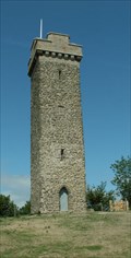
|  Flounders' Folly - Shropshire, UK Flounders' Folly - Shropshire, UK
in UK Historical Markers Flounders' Folly is a tower, built in 1838, on Callow Hill, between Craven Arms and Ludlow, Shropshire, England. The tower is approximately 80 feet (24 m) tall and 16 feet (4.9 m) square. posted by: Superted location: West Midlands, United Kingdom date approved: 01/21/2010 last visited: never |
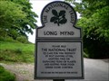 view gallery view galleryN5.3 km |  Long Mynd, Shropshire Long Mynd, Shropshire
in National Trust U.K. The Long Mynd in Shropshire, is a part of the Shropshire Hills an Area of Outstanding Natural Beauty. posted by: DesG location: United Kingdom date approved: 06/08/2009 last visited: 12/15/2000 |
 view gallery view gallery SW6.1 km SW6.1 km
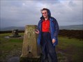
|  Wart Hill trig point - Round Oak, Shropshire, UK Wart Hill trig point - Round Oak, Shropshire, UK
in U.K. and Ireland Trigpoints A white painted trig on the tree-topped Wart Hill in Shropshire. posted by: Superted location: West Midlands, United Kingdom date approved: 01/19/2010 last visited: 10/30/2018 |
 view gallery view galleryS6.3 km | Land of Lost Content - Craven Arms, Shropshire UK in Oddball Museums Land of Lost Content, which also calls itself the National Museum of British Popular Culture, is in an old market building in the town of Craven Arms, Shropshire. posted by: Superted location: West Midlands, United Kingdom date approved: 02/02/2010 last visited: 04/17/2011 |
 view gallery view gallery NW6.4 km NW6.4 km
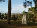
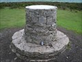
|  Long Mynd Toposcope, Shropshire Long Mynd Toposcope, Shropshire
in Orientation Tables Long Mynd Toposcope 516 metres (1693 ft) posted by: DesG location: United Kingdom date approved: 06/18/2009 last visited: 08/31/2017 |
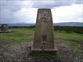 view gallery view galleryNW6.4 km | Long Mount (Pole Bank/Long Mynd) Triangulation Pillar in U.K. and Ireland Trigpoints Trig Point situated at the highest point on the Long Mynd, a beautiful range of hills to the west of Church Stretton in Shropshire.
posted by: DesG location: United Kingdom date approved: 06/08/2009 last visited: 08/31/2017 |
 view gallery view galleryNW6.4 km |  Long Mynd - Pole Bank Long Mynd - Pole Bank
in Mountain Summits Long Mynd - Pole Bank (G/WB-005) This is the highest point of a beautiful range of hills to the west of Church Stretton in Shropshire. posted by:  charlieg0pzo charlieg0pzo location: United Kingdom date approved: 01/02/2007 last visited: 08/31/2017 |
 view gallery view galleryN6.6 km |  All Stretton Youth Hostel - Shropshire, UK All Stretton Youth Hostel - Shropshire, UK
in Hostels A modernised small stone building that sleeps up to ten people. posted by: Superted location: West Midlands, United Kingdom date approved: 01/20/2010 last visited: 06/09/2013 |
 view gallery view galleryS7.2 km |  Stokesay Castle Stokesay Castle
in Castles The finest and best preserved 13th century fortified manor house in England. posted by: reelcutter location: United Kingdom date approved: 02/13/2009 last visited: 08/21/2018 |
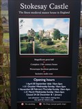 view gallery view galleryS7.2 km |  Stokesay Castle Stokesay Castle
in English Heritage - Cadw - Historic Scotland A 13th century fortified manor house. posted by: reelcutter location: United Kingdom date approved: 02/14/2009 last visited: 08/21/2018 |
 view gallery view galleryS7.2 km |  WWI memorial, Stokesay, Shropshire, England WWI memorial, Stokesay, Shropshire, England
in World War I Memorials and Monuments World War I memorial to the fallen and the survivors from the village posted by: The_Senior_Crabbes location: West Midlands, United Kingdom date approved: 08/24/2012 last visited: 08/21/2018 |
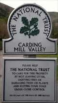 view gallery view galleryNE8 km | Carding Mill Valley in National Trust U.K. A secluded valley flanked by the long mynd. posted by: reelcutter location: United Kingdom date approved: 04/13/2009 last visited: 12/08/2012 |
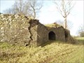 view gallery view galleryS8.4 km |  Stokesay Lime kilns - Craven Arms, Shropshire, UK Stokesay Lime kilns - Craven Arms, Shropshire, UK
in Ovens and Kilns A pair of lime kilns close to the village of Stokesay near Craven Arms in Shropshire. posted by: Superted location: West Midlands, United Kingdom date approved: 01/19/2010 last visited: 04/11/2010 |
 view gallery view gallerySW9 km |  The Arbor Tree - Aston-on-Clun, Shropshire. SY7 8EN The Arbor Tree - Aston-on-Clun, Shropshire. SY7 8EN
in Historic Trees One of the last trees celebrated in an Arbor Day festival. posted by: greysman location: West Midlands, United Kingdom date approved: 10/25/2018 last visited: never |
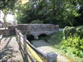 view gallery view gallerySW9 km |  Two-arch Bridge, School Bank, Aston-on-Clun, Shropshire. SY7 8ES Two-arch Bridge, School Bank, Aston-on-Clun, Shropshire. SY7 8ES
in Arch Bridges A two-arch road bridge over a tributary of the River Clun. posted by: greysman location: West Midlands, United Kingdom date approved: 11/02/2018 last visited: never |
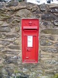 view gallery view galleryNW9.3 km |  Victorian Post Box - Bridges, Shropshire Victorian Post Box - Bridges, Shropshire
in Victorian Post Boxes Wall mounted post box in small rural community. posted by: Greygeeza&Tike location: West Midlands, United Kingdom date approved: 09/08/2009 last visited: never |
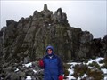 view gallery view galleryNW12.6 km | Stiperstones in Mountain Summits Stiperstones (G/WB-003) This summit is one of the best known landmarks in the county of Shropshire with the famous Devil's Chair and superb views. posted by: charlieg0pzo location: United Kingdom date approved: 02/11/2007 last visited: 02/25/2014 |
 view gallery view gallery SE15.4 km SE15.4 km
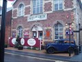
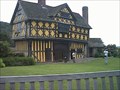
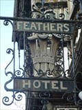
|  The Feathers Hotel, Bull Ring, Ludlow, Shropshire, England The Feathers Hotel, Bull Ring, Ludlow, Shropshire, England
in Pictorial Pub Signs The Feathers Hotel, Ludlow posted by: The_Senior_Crabbes location: West Midlands, United Kingdom date approved: 06/27/2015 last visited: 08/20/2018 |
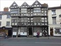 view gallery view gallerySE15.4 km |  The Feathers Hotel, Bull Ring, Ludlow, Shropshire, England The Feathers Hotel, Bull Ring, Ludlow, Shropshire, England
in Pubs and Inns The Feathers Hotel, Ludlow posted by: The_Senior_Crabbes location: West Midlands, United Kingdom date approved: 06/29/2015 last visited: 08/20/2018 |
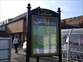 view gallery view gallerySE15.6 km |  A "You are here" Ludlow, Shropshire UK A "You are here" Ludlow, Shropshire UK
in 'You Are Here' Maps A "You are here" map in a carpark in Ludlow, it shows a map of the town centre. posted by: Brentorboxer location: United Kingdom date approved: 10/16/2007 last visited: 01/19/2014 |
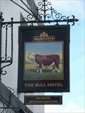 view gallery view gallerySE15.6 km | The Bull Hotel, Bull Ring, Ludlow, Shropshire, England in Pictorial Pub Signs The Bull Hotel, Ludlow posted by: The_Senior_Crabbes location: West Midlands, United Kingdom date approved: 06/27/2015 last visited: 08/20/2018 |
|