 view gallery view gallery NE0.3 km NE0.3 km
|   Red Telephone Box - Lea Bridge Road, London, UK Red Telephone Box - Lea Bridge Road, London, UK
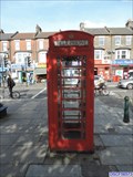
in Red Telephone Boxes This red telephone box is located on a large, pedestrianised traffic island on the south east side of Lea Bridge Road at the junction with Church Road. posted by:  Master Mariner Master Mariner location: London, United Kingdom date approved: 09/29/2015 last visited: never |
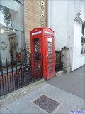 view gallery view galleryNE0.3 km | Red Telephone Box - Lea Bridge Road, London, UK in Red Telephone Boxes This red K6 telephone box is on the south east side of Lea Bridge Road outside the Carnegie Lea Bridge Library. posted by: Master Mariner location: London, United Kingdom date approved: 10/05/2015 last visited: never |
 view gallery view gallery W0.3 km W0.3 km
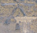
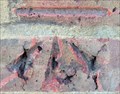
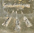
|  Cut Bench Mark - Lea Bridge Road, London, UK Cut Bench Mark - Lea Bridge Road, London, UK
in U.K. and Ireland Trigpoints This mark is cut into a short section of brick wall on the south east side of Lea Bridge Road. posted by: Master Mariner location: London, United Kingdom date approved: 09/29/2015 last visited: never |
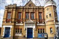
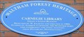 view gallery view galleryNE0.3 km |  Carnegie Library - Lea Bridge Road, London, UK Carnegie Library - Lea Bridge Road, London, UK
in Blue Plaques This Waltham Forest Heritage blue plaque is attached to the north west face of the Carnegie Library in Lea Bridge Road in Leyton, east London. The plaque advises that the building was "erected in 1905". posted by: Master Mariner location: London, United Kingdom date approved: 10/05/2015 last visited: never |
 view gallery view galleryW0.5 km | Cut Bench Mark - Burwell Road, London, UK in U.K. and Ireland Trigpoints This mark is cut into the brickwork of a post at the end of a wall. The mark is on the south west side of Burwell Road. posted by: Master Mariner location: London, United Kingdom date approved: 09/29/2015 last visited: never |
 view gallery view gallery N0.5 km N0.5 km
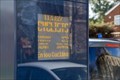
|  Counting Display "Cyclists" - Quietway, Markhouse Road, London, UK Counting Display "Cyclists" - Quietway, Markhouse Road, London, UK
in Counting and Measuring Displays This display counts cyclists that use a Quietway located in north London. The display shows the number of cyclists that pass the display in a day and the total for the year. posted by: Master Mariner location: London, United Kingdom date approved: 02/27/2020 last visited: never |
 view gallery view gallery SE0.6 km SE0.6 km
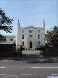
|  Etloe House - Church Road, London, UK Etloe House - Church Road, London, UK
in Satellite Imagery Oddities Etloe House, built in 1760, is a Grade II listed building in Leyton, east London. It is located on the south west side of Church Road behind a high boundary wall. The gates are usually open and the building can be seen from the street. posted by: Master Mariner location: London, United Kingdom date approved: 10/03/2015 last visited: 01/11/2021 |
 view gallery view galleryN0.6 km |  St Saviour's Church - Markhouse Road, London, UK St Saviour's Church - Markhouse Road, London, UK
in This Old Church St Saviour's Anglican church was built in 1874 to the designs of T F Dolman. The Grade II listed building, that was ravaged by fire in 1945, is still used for worship today by the Church of England. posted by: Master Mariner location: London, United Kingdom date approved: 02/28/2020 last visited: never |
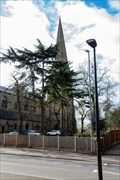 view gallery view galleryN0.6 km |  St Saviour's Church - Markhouse Road, London, UK St Saviour's Church - Markhouse Road, London, UK
in Anglican and Episcopal Churches St Saviour's Anglican church was built in 1874 to the designs of T F Dolman. The Grade II listed building, that was ravaged by fire in 1945, is still used for worship today by the Church of England. posted by: Master Mariner location: London, United Kingdom date approved: 02/28/2020 last visited: never |
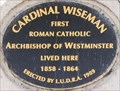 view gallery view gallerySE0.6 km | Cardinal Wiseman - Church Road, London, UK in Blue Plaques This black plaque, to Cardinal Wiseman, is housed in a purpose-made stone mount atop a wall along the boundary of Etloe House in Leyton, east London. It is to be found on the south west side of Church Road and advises the Cardinal "lived here". posted by: Master Mariner location: London, United Kingdom date approved: 09/29/2015 last visited: 01/11/2021 |
 view gallery view galleryNE0.6 km |  Victorian Pillar Box - Boundary Road - Walthamstow - London - UK Victorian Pillar Box - Boundary Road - Walthamstow - London - UK
in Victorian Post Boxes A Victorian pillar box on Boundary Road in Walthamstow, London, UK. posted by:  ntpayne ntpayne location: London, United Kingdom date approved: 02/19/2020 last visited: 02/26/2020 |
 view gallery view galleryW0.6 km |  Lea Bridge Railway Station - Argall Way, London, UK Lea Bridge Railway Station - Argall Way, London, UK
in Wikipedia Entries Leab Bridge railway station re-opened as recently as 2016. It handles services operated by Greater Anglia and is located on the south west side of Argall Way at the junction with Lea Bridge Road. posted by: Master Mariner location: London, United Kingdom date approved: 01/31/2021 last visited: never |
 view gallery view galleryW0.6 km |  Lea Bridge Railway Station - Argall Way, London, UK Lea Bridge Railway Station - Argall Way, London, UK
in Train Stations/Depots Lea Bridge railway station re-opened as recently as 2016. It handles services operated by Greater Anglia and is located on the south west side of Argall Way at the junction with Lea Bridge Road. posted by: Master Mariner location: London, United Kingdom date approved: 02/01/2021 last visited: 02/10/2021 |
 view gallery view gallery SW0.6 km SW0.6 km
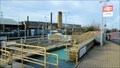
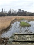
|  WaterWorks Nature Reserve - Leyton, London, UK WaterWorks Nature Reserve - Leyton, London, UK
in Birdwatching Locations A redundant water treatment works, now protected as a nature reserve and education resource. posted by: OrientGeo location: London, United Kingdom date approved: 01/11/2021 last visited: 01/31/2021 |
 view gallery view galleryN0.8 km | The Lighthouse Methodist Church - Markhouse Road, London, UK in This Old Church The Lighthouse or, to give it its full name, the Lighthouse Methodist Church, is located at the junction of Markhouse Road and Downsfield Road. It was built in 1872 and opened in 1873. It is a Grade II listed building. posted by: Master Mariner location: London, United Kingdom date approved: 02/28/2020 last visited: never |
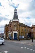 view gallery view galleryN0.8 km |  The Lighthouse Methodist Church - Markhouse Road, London, UK The Lighthouse Methodist Church - Markhouse Road, London, UK
in Methodist Churches The Lighthouse or, to give it its full name, the Lighthouse Methodist Church, is located at the junction of Markhouse Road and Downsfield Road. It was built in 1872 and opened in 1873. It is a Grade II listed building. posted by: Master Mariner location: London, United Kingdom date approved: 02/28/2020 last visited: never |
 view gallery view galleryN0.8 km |  1892 - The Lighthouse Methodist Church - Markhouse Road, London, UK 1892 - The Lighthouse Methodist Church - Markhouse Road, London, UK
in Dated Buildings and Cornerstones The Lighthouse or, to give it its full name, the Lighthouse Methodist Church, is located at the junction of Markhouse Road and Downsfield Road. It was built in 1872 and opened in 1873. It is a Grade II listed building. posted by: Master Mariner location: London, United Kingdom date approved: 02/29/2020 last visited: never |
 view gallery view gallery E1 km E1 km
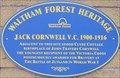
| Jack Cornwell VC - Clyde Place, London, UK in Blue Plaques This Waltham Forest Heritage blue plaque indicates that Victoria Cross recipient Jack Cornwell was born in a cottage that stood near the building on which the plaque is mounted. posted by: Master Mariner location: London, United Kingdom date approved: 10/05/2015 last visited: never |
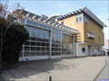 view gallery view gallerySE1 km |  Leyton Fire Station Leyton Fire Station
in Firehouses Leyton fire station is located on the south west side of Church Road, where it bends, at the junction with Oliver Road in east London. posted by: Master Mariner location: London, United Kingdom date approved: 10/03/2015 last visited: 01/11/2021 |
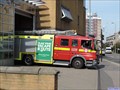 view gallery view gallerySE1 km | Pump Engine DPL1236 - Leyton Fire Station, London, UK in Fire Fighting Vehicles This pump was photographed leaving Leyton fire station in Church Road, Leyton, east London. posted by: Master Mariner location: London, United Kingdom date approved: 10/03/2015 last visited: never |
 view gallery view gallerySE1 km | Leyton Fire Station - Church Road, London, UK in Satellite Imagery Oddities Leyton fire station is located on the south west side of Church Road, where it bends, at the junction with Oliver Road in east London. posted by: Master Mariner location: London, United Kingdom date approved: 10/03/2015 last visited: never |
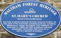 view gallery view gallerySE1 km | St Mary's Church - Church Road, London, UK in Blue Plaques This Waltham Forest Heritage blue plaque is mounted on St Mary's the parish church of Leyton. The church is located on the north west side of Church Road with the plaque being close to the door on the south east face of the building. posted by: Master Mariner location: London, United Kingdom date approved: 09/29/2015 last visited: never |
 view gallery view galleryNE1.1 km | Cut Bench Mark - Boundary Road, London, UK in U.K. and Ireland Trigpoints This mark is cut into the brickwork of the buttress of a railway bridge that carries tracks across Boundary Road. The mark is on the north west side of Boundary Road at the western side of the bridge. posted by: Master Mariner location: London, United Kingdom date approved: 10/02/2015 last visited: never |
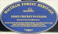 view gallery view galleryE1.1 km | Essex Cricket Pavilion - High Road Leyton, London, UK in Blue Plaques This Waltham Forest Heritage blue plaque is attached to the front of the cricket pavilion in, what is now, Leyton Cricket Ground but was once the home of Essex CCC. The wooden pavilion was built in 1886. posted by: Master Mariner location: London, United Kingdom date approved: 10/04/2015 last visited: never |
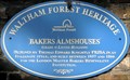 view gallery view galleryNE1.1 km | Bakers Almshouses - Lea Bridge Road, London, UK in Blue Plaques This Waltham Forest Heritage blue plaque is attached to a wall at the entrance to the Baker's Almshouses gardens on the north west side of Lea Bridge Road in Leyton. posted by: Master Mariner location: London, United Kingdom date approved: 10/09/2015 last visited: never |
|