 view gallery view gallery NE1.1 km NE1.1 km
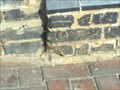
|   Cut Bench Mark, Norwood Junction Station, London UK Cut Bench Mark, Norwood Junction Station, London UK
in U.K. and Ireland Trigpoints A Cut Bench Mark on the railway station building. posted by:  AngelPick AngelPick location: London, United Kingdom date approved: 08/27/2011 last visited: 12/26/2020 |
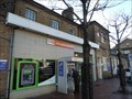
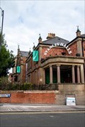
 view gallery view galleryNE1.1 km |  Norwood Junction Station - Station Road, South Norwood, London, UK Norwood Junction Station - Station Road, South Norwood, London, UK
in Train Stations/Depots Norwood Junction station serves both mainline services and London Overground. The station can be accessed from the north west side (Station Road) and south east side (Clifford Road) of the tracks. posted by:  Master Mariner Master Mariner location: London, United Kingdom date approved: 07/28/2014 last visited: 12/26/2020 |
 view gallery view galleryNE1.1 km |  Norwood Junction Station - Station Road, South Norwood, London, UK Norwood Junction Station - Station Road, South Norwood, London, UK
in Wikipedia Entries Norwood Junction station serves both mainline services and London Overground. The station can be accessed from the north west side (Station Road) and south east side (Clifford Road) of the tracks. posted by: Master Mariner location: London, United Kingdom date approved: 07/25/2014 last visited: never |
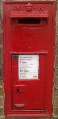 view gallery view galleryNE1.1 km |  Norwood Junction Station Post Box, Norwood, London SE25. UK Norwood Junction Station Post Box, Norwood, London SE25. UK
in Victorian Post Boxes Norwood Junction Station set in station building wall. posted by: AngelPick location: London, United Kingdom date approved: 05/18/2011 last visited: 12/26/2020 |
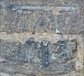 view gallery view galleryNE1.1 km |  Cut Bench Mark - Clifford Road, South Norwood, London, UK Cut Bench Mark - Clifford Road, South Norwood, London, UK
in European Historic Survey Stones, Monuments and Benchmarks This mark is cut into brickwork on the west side of Clifford Road. The building is a part of Norwood Junction railway station with the being just to the north of the entry of a subway that leads under the tracks to the other side of the station. posted by: Master Mariner location: London, United Kingdom date approved: 07/25/2014 last visited: never |
 view gallery view galleryNE1.1 km | Cut Bench Mark - Clifford Road, South Norwood, London, UK in U.K. and Ireland Trigpoints This mark is cut into brickwork on the west side of Clifford Road. The building is a part of Norwood Junction railway station with the being just to the north of the entry of a subway that leads under the tracks to the other side of the station. posted by: Master Mariner location: London, United Kingdom date approved: 07/25/2014 last visited: never |
 view gallery view galleryNE1.3 km |  Stanley Tech, South Norwood Hill Stanley Tech, South Norwood Hill
in Immortalized in Lyrics Captain Sensible sings that he attended Stanley Tech in his song "Croydon" posted by: Team Sieni location: London, United Kingdom date approved: 06/22/2021 last visited: 07/27/2021 |
 view gallery view gallery SW1.6 km SW1.6 km
| West Croydon Station - Station Road, Croydon, UK in Train Stations/Depots Croydon West Station is orientated in a north east/south west direction with exits on both Station Road, on the south east side of the station, and London Road on the south west side of the station. posted by: Master Mariner location: London, United Kingdom date approved: 09/19/2013 last visited: 09/27/2013 |
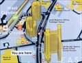
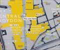
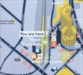 view gallery view gallerySW1.6 km |  You Are Here - Station Road, Croydon, UK You Are Here - Station Road, Croydon, UK
in 'You Are Here' Maps This "you are here" map is outside the eastern entrance to West Croydon station on the west side of Station Road - opposite the bus station. posted by: Master Mariner location: London, United Kingdom date approved: 09/17/2013 last visited: 09/23/2013 |
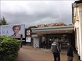 view gallery view gallerySW1.6 km | West Croydon Station - Station Road, Croydon, UK in Wikipedia Entries Croydon West Station is orientated in a north east/south west direction with exits on both Station Road, on the south east side of the station, and London Road on the south west side of the station. posted by: Master Mariner location: London, United Kingdom date approved: 09/18/2013 last visited: 09/30/2013 |
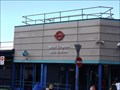 view gallery view gallerySW1.8 km |  West Croydon Bus Station - Station Road, Croydon, UK West Croydon Bus Station - Station Road, Croydon, UK
in Bus Stations West Croydon bus station is on the east side of Station Road opposite West Croydon railway station. posted by: Master Mariner location: London, United Kingdom date approved: 09/19/2013 last visited: 09/27/2013 |
 view gallery view gallerySW1.8 km | You Are Here - Wellesley Road, Croydon, UK in 'You Are Here' Maps This "you are here" map is on the west side of Wellesley Road close to the junction with Poplar Walk and St Michael's Road in Croydon. posted by: Master Mariner location: London, United Kingdom date approved: 06/15/2014 last visited: never |
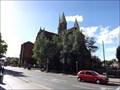 view gallery view gallerySW1.8 km |  St Michael and All Angels - Poplar Walk, Croydon, UK St Michael and All Angels - Poplar Walk, Croydon, UK
in This Old Church The Anglican church of St Michael and All Angels is on the north west side of Poplar Walk in Croydon. The foundation stone was laid on 20th April 1880. posted by: Master Mariner location: London, United Kingdom date approved: 09/19/2013 last visited: 07/07/2013 |
 view gallery view gallerySW1.8 km |  Saint Michael and All Angels - Poplar Walk, Croydon, UK Saint Michael and All Angels - Poplar Walk, Croydon, UK
in Anglican and Episcopal Churches The Anglican church of St Michael and All Angels is on the north west side of Poplar Walk in Croydon. The foundation stone was laid on 20th April 1880. posted by: Master Mariner location: London, United Kingdom date approved: 09/19/2013 last visited: 07/07/2013 |
 view gallery view gallerySW1.9 km |  The Old Fox & Hounds - London Road, Croydon, UK The Old Fox & Hounds - London Road, Croydon, UK
in Pictorial Pub Signs The Old Fox & Hounds is on the south west side of London Road at the junction with Derby Road and is opposite the entrance to West Croydon station. posted by: Master Mariner location: London, United Kingdom date approved: 09/18/2013 last visited: 11/11/2013 |
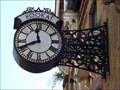
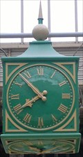 view gallery view gallerySW2.1 km |  Clock, Whitgift Centre, North End, Croydon, Surrey UK Clock, Whitgift Centre, North End, Croydon, Surrey UK
in Town Clocks Right in the heart of one of Croydons Shopping Centres you will find this five faced clock. posted by: AngelPick location: South East England, United Kingdom date approved: 06/22/2012 last visited: 09/16/2013 |
 view gallery view gallerySW2.1 km |  Chimney Pots, North End, Croydon, Surrey UK Chimney Pots, North End, Croydon, Surrey UK
in Unique Chimneys and Chimney Pots In the middle of the pedestrianised North End, right in the heart of Croydons main shopping area you will see these tudoresque chimney pots. posted by: AngelPick location: South East England, United Kingdom date approved: 06/22/2012 last visited: 09/16/2013 |
 view gallery view gallery S2.1 km S2.1 km
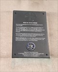
|  Stay or Stake Cross Plaque, George Street, Croydon, Surrey UK Stay or Stake Cross Plaque, George Street, Croydon, Surrey UK
in UK Historical Markers The Stay or Stake Cross was one of four crosses marking the boundaries of Croydon in Elizabethan times. posted by: AngelPick location: South East England, United Kingdom date approved: 06/17/2012 last visited: 09/17/2013 |
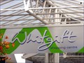 view gallery view gallerySW2.1 km |  Whitgift Centre - North End, Croydon, UK Whitgift Centre - North End, Croydon, UK
in Indoor Malls The Whitgift Centre is a large shopping mall in Croydon. It sits between Wellesley Road, on its east side, and North End, a pedestrianised street, on its west side. posted by: Master Mariner location: London, United Kingdom date approved: 09/29/2013 last visited: 09/30/2013 |
 view gallery view gallerySW2.1 km | Whitgift Centre - North End, Croydon, UK in Wikipedia Entries The Whitgift Centre is a large shopping mall in Croydon. It sits between Wellesley Road, on its east side, and North End, a pedestrianised street, on its west side. posted by: Master Mariner location: London, United Kingdom date approved: 09/19/2013 last visited: 09/25/2013 |
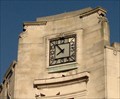 view gallery view galleryS2.1 km | Clock, George Street, Croydon, Surrey UK in Town Clocks An “Art Deco” clockface that tells the right time! On an unnamed building in the centre of Croydon. posted by: AngelPick location: South East England, United Kingdom date approved: 06/17/2012 last visited: 09/17/2013 |
 view gallery view gallerySW2.1 km | Kookai Clock - North End, Croydon, UK in Town Clocks This clock is on the west side of the pedestrianised street, North End, opposite the Whitgift Centre. posted by: Master Mariner location: London, United Kingdom date approved: 09/19/2013 last visited: 09/25/2013 |
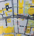 view gallery view galleryS2.1 km | You Are Here - George Street, Croydon in 'You Are Here' Maps This "you are here" mao is on the north side of George Street to the south of the Whitgift Centre. posted by: Master Mariner location: London, United Kingdom date approved: 06/15/2014 last visited: never |
 view gallery view gallerySW2.1 km | You Are Here - North End, Croydon, UK in 'You Are Here' Maps This "you are here" map is in the pedestrianised North End about 150 mtres north of George Street. posted by: Master Mariner location: London, United Kingdom date approved: 09/17/2013 last visited: 09/19/2013 |
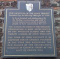 view gallery view galleryS2.3 km | Hospital of the Holy Trinity/Whitgift Almshouses, George Street, Croydon Surrey UK in UK Historical Markers So much history here, built in 1596, it was a hospital originally and latterly an Almshouse for the poor etc. posted by: AngelPick location: South East England, United Kingdom date approved: 11/19/2011 last visited: 09/17/2013 |
|