 view gallery view gallery N1.9 km N1.9 km
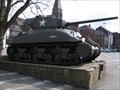
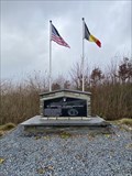
|   M4A1(76) Sherman, La-Roche-en-Ardenne M4A1(76) Sherman, La-Roche-en-Ardenne
in Military Ground Equipment Displays M4A1(76) Sherman in the centre of the town posted by:  afvregister.org afvregister.org location: Belgium date approved: 11/13/2008 last visited: 06/03/2011 |
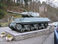 view gallery view galleryN1.9 km | M10 17Pdr, La-Roche-en-Ardenne, Belgium in Military Ground Equipment Displays M10 Achilles, monument for the liberation of La-Roche-en-Ardenne posted by: afvregister.org location: Belgium date approved: 11/13/2008 last visited: 04/30/2010 |
 view gallery view gallery NW6 km NW6 km
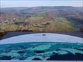
|  Vue sur la vallée de l'Ourthe - Rendeux - Belgique Vue sur la vallée de l'Ourthe - Rendeux - Belgique
in Orientation Tables FR] Table semi-circulaire d'orientation sur la vallée de l'Ourthe. [EN] Semi-circular orientation table over the Ourthe valley. posted by:  PaulLassiter PaulLassiter location: Luxembourg, Belgium date approved: 12/11/2020 last visited: never |
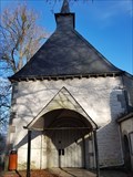
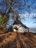 view gallery view galleryNW6 km |  Ermitage et chapelle Saint-Thibaut - Rendeux - Belgique Ermitage et chapelle Saint-Thibaut - Rendeux - Belgique
in Wikipedia Entries [FR] Edifice religieux de deux pièces construit sur un éperon rocheux dominant la vallée de l’Ourthe [EN] Two-room religious building built on a rocky spur overlooking the valley of the river Ourthe. posted by: PaulLassiter location: Luxembourg, Belgium date approved: 12/09/2020 last visited: never |
 view gallery view galleryNW6 km |  1639 - Ermitage et chapelle Saint-Thibaut - Rendeux - Belgique 1639 - Ermitage et chapelle Saint-Thibaut - Rendeux - Belgique
in Dated Buildings and Cornerstones [FR] Pierre armoriée au-dessus de la porte de la chapelle. [EN] Armorial stone above the door of the chapel. posted by: PaulLassiter location: Luxembourg, Belgium date approved: 12/13/2020 last visited: never |
 view gallery view galleryNW6 km |  Ermitage et chapelle Saint-Thibaut - Rendeux - Belgique Ermitage et chapelle Saint-Thibaut - Rendeux - Belgique
in Belgium Monument Registers [FR] Edifice religieux de deux pièces construit sur un éperon rocheux dominant la vallée de l’Ourthe [EN] Two-room religious building built on a rocky spur overlooking the valley of the river Ourthe. posted by: PaulLassiter location: Luxembourg, Belgium date approved: 12/11/2020 last visited: never |
 view gallery view gallery E8 km E8 km
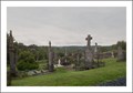
|  Ollomont cemetery - Ollomont - Luxembourg - Belgium Ollomont cemetery - Ollomont - Luxembourg - Belgium
in Worldwide Cemeteries Verry old cemetery of Ollomont in Belgium-Ardennes posted by: lopac44 location: Luxembourg, Belgium date approved: 08/25/2011 last visited: 06/04/2011 |
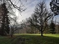 view gallery view galleryNW8.5 km |  Arboretum Robert Lenoir - Rendeux - Belgique Arboretum Robert Lenoir - Rendeux - Belgique
in Arboretums [FR] Vaste et exceptionnel arboretum en bordure de l’Ourthe. [EN] Vast and exceptional arboretum on the banks of the river Ourthe. posted by: PaulLassiter location: Luxembourg, Belgium date approved: 12/11/2020 last visited: never |
 view gallery view galleryNW8.5 km | Arboretum Robert Lenoir - Rendeux - Belgique in Wikipedia Entries [FR] Vaste et exceptionnel arboretum en bordure de l’Ourthe. [EN] Vast and exceptional arboretum on the banks of the river Ourthe. posted by: PaulLassiter location: Luxembourg, Belgium date approved: 12/09/2020 last visited: never |
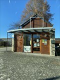 view gallery view gallery SE11.9 km SE11.9 km
|  Office du Tourisme - Bertogne Office du Tourisme - Bertogne
in Tourist Information Centers - Visitor Centers Office du tourisme de Bertogne posted by: Cecticide location: Luxembourg, Belgium date approved: 12/02/2021 last visited: never |
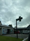 view gallery view gallerySE11.9 km |  T&T Pharmacie Detry - Bertogne, Belgium T&T Pharmacie Detry - Bertogne, Belgium
in Time and Temperature Signs Next to pharmacy you can find the time and temperature sign. posted by: Cecticide location: Luxembourg, Belgium date approved: 06/11/2022 last visited: never |
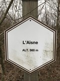 view gallery view gallery NE12.2 km NE12.2 km
|  560 m. Signe d'altitude du lieu L'Aisne - Manhay - Belgique 560 m. Signe d'altitude du lieu L'Aisne - Manhay - Belgique
in Elevation Signs Signe d'altitude du lieu L'Aisne posted by: franketmuriel location: Luxembourg, Belgium date approved: 12/02/2018 last visited: never |
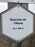 view gallery view galleryNE12.9 km | 600 m. Signe d'altitude du lieu Sources de l'Aisne - Manhay - Belgique in Elevation Signs Signe d'altitude du lieu Sources de l'Aisne posted by: franketmuriel location: Luxembourg, Belgium date approved: 12/02/2018 last visited: 10/26/2023 |
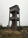 view gallery view galleryNE12.9 km |  Tour d'observation du Plateau des Tailles - Manhay - Belgique Tour d'observation du Plateau des Tailles - Manhay - Belgique
in Look-Out Towers Cet tour permet d'observer la fagne du Pouhon, tourbière qui accueille les sources de l’Aisne et la nature environante. posted by: franketmuriel location: Luxembourg, Belgium date approved: 12/02/2018 last visited: 10/26/2023 |
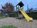 view gallery view gallerySE13.4 km |  Givry - Le toboggan Givry - Le toboggan
in Public Playgrounds Le toboggan de Givry posted by: Cecticide location: Luxembourg, Belgium date approved: 10/27/2021 last visited: never |
 view gallery view gallery S13.4 km S13.4 km
|  Barriere Hinck - WW2 - Saint-Ode, Belgium Barriere Hinck - WW2 - Saint-Ode, Belgium
in Field Hospitals Division Clearing Station of the 326th Airborne Medical Company with small hospital posted by: Cecticide location: Luxembourg, Belgium date approved: 12/13/2021 last visited: never |
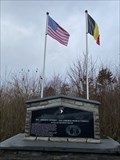
 view gallery view galleryS13.4 km |  101st Airborne Division & 326th Airborne Medical Company Memorial - Saint-Ode 101st Airborne Division & 326th Airborne Medical Company Memorial - Saint-Ode
in World War II Memorials / Monuments Memorial for the 101st Airborne Division & 326th Airborne Medical Company posted by: Cecticide location: Luxembourg, Belgium date approved: 12/16/2021 last visited: never |
 view gallery view gallerySE13.4 km |  Vous êtes ici - Givry, Belgium Vous êtes ici - Givry, Belgium
in 'You Are Here' Maps Plan à coté de la table de picnic posted by: Cecticide location: Luxembourg, Belgium date approved: 01/27/2022 last visited: never |
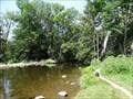
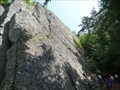 view gallery view galleryNW13.5 km |  Plage de Renissart - Hotton - LUX - Belgium Plage de Renissart - Hotton - LUX - Belgium
in Established Rock Climbing Areas Famous Rocks in Hotton called "Plage de Raissart" posted by: CADS11 location: Luxembourg, Belgium date approved: 07/28/2019 last visited: 07/27/2019 |
 view gallery view galleryNW13.5 km | Plage de Renissart - Hotton - LUX - Belgium in Belgium Monument Registers Ensemble formé par les rochers surplombant l'Ourthe, à l'endroit dénommé "Plage de Renissart" sur lesquels subsistent les vestiges d'un antique camp de refuge connu sous le nom de "Ti-Château" posted by: CADS11 location: Luxembourg, Belgium date approved: 07/27/2019 last visited: never |
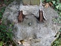 view gallery view galleryNW13.7 km |  NGI Meetpunt Uak19.1 - Hotton - Luxemburg - Belgium NGI Meetpunt Uak19.1 - Hotton - Luxemburg - Belgium
in Belgium Benchmarks Route Manhay - Hotton posted by: CADS11 location: Luxembourg, Belgium date approved: 08/14/2019 last visited: never |
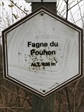 view gallery view galleryNE13.8 km | 635 m. Signe d'altitude du lieu Fagne du Pouhon - Manhay - Belgique in Elevation Signs Signe d'altitude du lieu Fagne du Pouhon posted by: franketmuriel location: Luxembourg, Belgium date approved: 12/02/2018 last visited: 10/26/2023 |
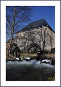 view gallery view galleryNW13.8 km |  Moulin Faber, Hotton, Luxemburg, Belgie Moulin Faber, Hotton, Luxemburg, Belgie
in Water Mills Watermill build in 1729 near the city of Hotton. posted by: lopac44 location: Luxembourg, Belgium date approved: 03/08/2010 last visited: 07/23/2019 |
 view gallery view galleryNW13.8 km | MOULIN FABER - Hotton - LUX - Belgium in Wikipedia Entries The Faber Mill is a watermill in Hotton posted by: CADS11 location: Luxembourg, Belgium date approved: 07/28/2019 last visited: 07/27/2019 |
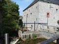
 view gallery view galleryNW13.8 km |  MUSÉE MOULIN FABER - Hotton - LUX - Belgium MUSÉE MOULIN FABER - Hotton - LUX - Belgium
in History Museums The Faber Mill is a watermill in Hotton posted by: CADS11 location: Luxembourg, Belgium date approved: 07/28/2019 last visited: 07/27/2019 |
|