 view gallery view gallery E12.4 km E12.4 km
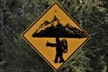
|   Hitchhiking sasquatches – Xwakw’áyak’in / Cheakamus 11 Hitchhiking sasquatches – Xwakw’áyak’in / Cheakamus 11
in Uncommon Crossing Signs Watching out for hitchhiking sasquatches in the Squamish Valley can be a real concern posted by:  Dunbar Loop Dunbar Loop location: British Columbia, Canada date approved: 02/10/2022 last visited: never |
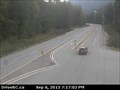
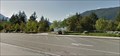
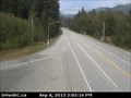 view gallery view galleryE14.5 km |  Hwy 99 at Alice Lake Webcam - Squamish, BC Hwy 99 at Alice Lake Webcam - Squamish, BC
in Web Cameras Our second webcam on the Sea to Sky is at Squamish Valley Road, west, and Alice Lake Road, east, about 10 km north of Squamish. posted by:  T0SHEA T0SHEA location: British Columbia, Canada date approved: 09/30/2013 last visited: 01/14/2014 |
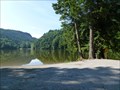 view gallery view galleryE14.8 km |  Alice Lake Provincial Park - British Columbia Alice Lake Provincial Park - British Columbia
in State/Provincial Parks Alice Lake is a very popular park between Vancouver and Whistler, BC. posted by: gypsie2 location: British Columbia, Canada date approved: 10/22/2012 last visited: never |
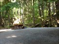 view gallery view galleryE15 km |  Alice Lake Campground, BC Alice Lake Campground, BC
in Campgrounds Camping in a provincial park close to Vancouver, BC. posted by: gypsie2 location: British Columbia, Canada date approved: 10/17/2012 last visited: never |
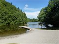
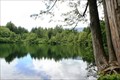
 view gallery view galleryE15.3 km |  Alice Lake, BC Alice Lake, BC
in Swimming Holes Lovely sandy beach in a provincial park. posted by: gypsie2 location: British Columbia, Canada date approved: 10/18/2012 last visited: never |
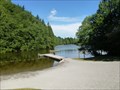
 view gallery view galleryE15.3 km |  Alice Lake, BC Alice Lake, BC
in Beaches Sandy swimming beach in a provincial park. posted by: gypsie2 location: British Columbia, Canada date approved: 10/26/2012 last visited: never |
 view gallery view galleryE15.8 km |  Alice Lake, BC Alice Lake, BC
in Natural Lakes One of 4 lakes in Alice Lake Provincial Park, BC. posted by: gypsie2 location: British Columbia, Canada date approved: 10/16/2012 last visited: never |
 view gallery view gallery SE16.7 km SE16.7 km
|  Subway, Squamish, BC Subway, Squamish, BC
in Subway Restaurants An easy stop if you're heading from Vancouver to Whistler, BC posted by: gypsie2 location: British Columbia, Canada date approved: 09/26/2012 last visited: 04/19/2013 |
 view gallery view gallerySE16.7 km |  Starbucks - Squamish, BC Starbucks - Squamish, BC
in Starbucks Stores An easy stop if you're headed from Vancouver to Whistler, BC. posted by: gypsie2 location: British Columbia, Canada date approved: 10/05/2012 last visited: never |
 view gallery view gallerySE18.2 km |  Panago Pizza, Squamish, BC Panago Pizza, Squamish, BC
in Pizza Shops - Regional Chains Downtown Squamish, BC posted by: gypsie2 location: British Columbia, Canada date approved: 10/29/2012 last visited: never |
 view gallery view gallery NE20.1 km NE20.1 km
| Hwy 99 Garibaldi Traffic Webcam - Whistler, BC in Web Cameras The third webcam is at the Chance Creek FSR. Doubtless someone took a chance here. posted by: T0SHEA location: British Columbia, Canada date approved: 09/30/2013 last visited: 01/14/2014 |
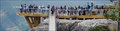
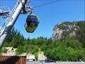 view gallery view gallerySE20.1 km |  Sea to Sky Gondola — Squamish, BC Sea to Sky Gondola — Squamish, BC
in Aerial Lifts There are three ways to get up the 885 meter Stawamus Chief. One, climb the 700 meter rock face that is close to vertical. Two, hike the 550 meter elevation gain on a trail. Or three, take the Sea to Sky Gondola service that opened in 2014. posted by: Dunbar Loop location: British Columbia, Canada date approved: 05/21/2015 last visited: never |
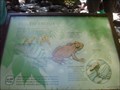 view gallery view gallerySE20.3 km |  Tailed Frogs - Shannon Falls, BC Tailed Frogs - Shannon Falls, BC
in Flora and Fauna Information Signs This sign has been slightly vandalized, but is still interesting. posted by: gypsie2 location: British Columbia, Canada date approved: 08/10/2010 last visited: never |
 view gallery view gallerySE20.3 km | Shannon Falls Provincial Park - British Columbia in State/Provincial Parks Day use park near Squamish, BC posted by: gypsie2 location: British Columbia, Canada date approved: 08/06/2010 last visited: 08/27/2008 |
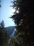
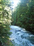
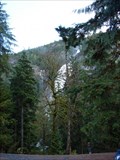 view gallery view gallerySE20.3 km |  Shannon Falls, Squamish, B.C. Shannon Falls, Squamish, B.C.
in Waterfalls Shannon Falls is located with easy highway access off of the Sea to Sky Highway (99) near Squamish, B.C.. posted by: Phoneguy Canuck location: British Columbia, Canada date approved: 11/11/2008 last visited: 05/19/2015 |
 view gallery view gallerySE21.1 km | Murrin Provincial Park - Squamish, BC in State/Provincial Parks This small wayside park along Highway 99 - The Sea to Sky Highway - has about ten rock faces that a popular rock climbing destinations. For those who do not clambering there are plenty of picnic tables along the shore of Browning Lake. posted by: Dunbar Loop location: British Columbia, Canada date approved: 06/11/2010 last visited: 04/12/2014 |
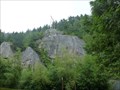 view gallery view gallerySE21.1 km |  Murrin Park, Squamish, BC Murrin Park, Squamish, BC
in Established Rock Climbing Areas Number of climbing areas in this small provincial park. posted by: gypsie2 location: British Columbia, Canada date approved: 10/28/2012 last visited: 04/12/2014 |
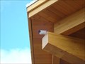 view gallery view gallerySE21.7 km | Sea to Sky Gondola web-cam SQUAMISH B.C. in Web Cameras This camera is located under the outside overhang of the 'Visitor Lodge' and Restaurant' of the upper gondola platform. posted by: Jake39 location: British Columbia, Canada date approved: 06/03/2014 last visited: never |
 view gallery view gallerySE21.7 km |  Sea to Sky Viewing Platform ~ SQUAMISH B.C. Sea to Sky Viewing Platform ~ SQUAMISH B.C.
in Look-Out Towers This is the "Main" upper viewing platform of the S&S gondola overlooking Howe Sound far below. posted by: Jake39 location: British Columbia, Canada date approved: 06/13/2014 last visited: never |
 view gallery view gallerySE22.2 km |  Highway 99 'Britannia Beach' View-Point ~ B.C. Highway 99 'Britannia Beach' View-Point ~ B.C.
in Scenic Roadside Look-Outs One of many Roadside stops along the "Sea to Sky" highway from Vancouver to north of Whistler. posted by: Jake39 location: British Columbia, Canada date approved: 10/02/2013 last visited: 08/20/2014 |
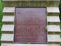 view gallery view gallerySE23.3 km |  CNHS - Britannia Mines Concentrator - Concentrateur-des-Mines-Britannia CNHS - Britannia Mines Concentrator - Concentrateur-des-Mines-Britannia
in Canadian National Historic Sites The plaque related to this National Historic Site is located along the Sea to Sky Highway in Britannia Beach. La plaque reliée à ce Lieu historique national est située le long de la route Sea to Sky à Britannia Beach. posted by: Weathervane location: British Columbia, Canada date approved: 06/17/2012 last visited: 11/06/2016 |
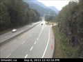 view gallery view gallery S26.2 km S26.2 km
| Hwy 99 at Furry Creek Webcam - Squamish, BC in Web Cameras Out of the city, out into the country and up the Sea to Sky Highway we go. Our first webcam is about 12 km. south of Squamish. Furry Creek - one wonders how it could have gotten its name. posted by: T0SHEA location: British Columbia, Canada date approved: 09/30/2013 last visited: 01/14/2014 |
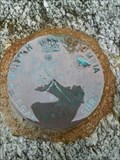 view gallery view galleryS26.9 km |  British Columbia Legal Survey - 2000 WT R R/W 661 British Columbia Legal Survey - 2000 WT R R/W 661
in Canadian Benchmarks Located on top of a boulder on the beach. Nice view of Howe Sound at this location. posted by: grafinator location: British Columbia, Canada date approved: 04/22/2013 last visited: 11/02/2013 |
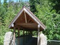 view gallery view galleryNE28.6 km |  Brandywine Falls Provincial Park, Whistler, BC Brandywine Falls Provincial Park, Whistler, BC
in Covered Bridges Covered pedestrian bridge in a provincial park. posted by: gypsie2 location: British Columbia, Canada date approved: 08/11/2010 last visited: never |
 view gallery view galleryNE28.6 km | Brandywine Falls Provincial Park - Whistler, BC in State/Provincial Parks Day use park just south of Whistler, BC posted by: gypsie2 location: British Columbia, Canada date approved: 08/09/2010 last visited: 08/25/2010 |
|