 view gallery view gallery SW3.4 km SW3.4 km
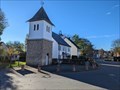
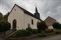
|   Belltower - Talling - Germany / Rhineland-Palatinate Belltower - Talling - Germany / Rhineland-Palatinate
in Bell Towers A belltower in a village in the Hochwald ringing in the morning and evening. posted by:  ColleIsarco ColleIsarco location: Rheinland-Pfalz, Germany date approved: 06/07/2023 last visited: never |
 view gallery view gallery SE3.4 km SE3.4 km
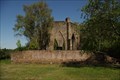
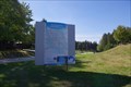
|  Kriegerdenkmal 1914/1918 - Thalfang, Deutschland Kriegerdenkmal 1914/1918 - Thalfang, Deutschland
in Deutsche Denkmallisten - German Monument Registers Kriegerdenkmal 1914/1918 östlich oberhalb des Ortes Thalfang, Deutschland. posted by:  dreamhummie dreamhummie location: Rheinland-Pfalz, Germany date approved: 02/01/2023 last visited: never |
 view gallery view gallerySE3.4 km |  Kriegerdenkmal 1914/1918 - Thalfang, Germany Kriegerdenkmal 1914/1918 - Thalfang, Germany
in World War I Memorials and Monuments Kriegerdenkmal 1914/1918 a World War I Memorial located east above the village of Thalfang, Germany. posted by: dreamhummie location: Rheinland-Pfalz, Germany date approved: 02/01/2023 last visited: never |
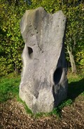
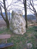 view gallery view gallerySW4 km |  Schönberg Menhir Schönberg Menhir
in Megalithic Monuments This menhir lies very close to a country road. posted by: RakeInTheCache location: Rheinland-Pfalz, Germany date approved: 03/17/2007 last visited: 11/14/2022 |
 view gallery view gallery W6.1 km W6.1 km
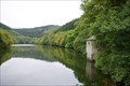
|  Dhrontalsperre - Heidenburg, Germany Dhrontalsperre - Heidenburg, Germany
in Wikipedia Entries The Dhrontalsperre in the valley of the Kleine Dhron near Heidenburg in Rhineland-Palatinate, Germany. posted by: dreamhummie location: Rheinland-Pfalz, Germany date approved: 10/14/2016 last visited: never |
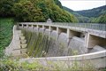 view gallery view galleryW6.3 km |  Water Dam Dhrontalsperre - Heidenburg, Germany Water Dam Dhrontalsperre - Heidenburg, Germany
in Water Dams Water Dam of Dhrontalsperre is a gravity dam located at the L148 near Heidenburg, Germany. posted by: dreamhummie location: Rheinland-Pfalz, Germany date approved: 10/15/2016 last visited: never |
 view gallery view gallerySE7.7 km |  Alfred Brotkorb - Thalfang, Germany Alfred Brotkorb - Thalfang, Germany
in Out of Place Graves A soldier's grave of Alfred Brotkorb along the road (L164) located between Allenbach and Thalfang, Germany. posted by: dreamhummie location: Rheinland-Pfalz, Germany date approved: 02/01/2023 last visited: never |
 view gallery view gallerySE7.9 km |  636,8m - Thalfang, Germany 636,8m - Thalfang, Germany
in Elevation Signs Elevation Sign on between direction arrows at a parking along the road (L164) located between Allenbach and Thalfang, Germany. posted by: dreamhummie location: Rheinland-Pfalz, Germany date approved: 02/01/2023 last visited: never |
 view gallery view gallerySE8.7 km |  Summstein auf dem Erbeskopf - Rheinland-Pfalz, Germany Summstein auf dem Erbeskopf - Rheinland-Pfalz, Germany
in Humming Stones Der Summstein ist Teil des Sinneserfahrungswegs auf dem Erbeskopf, der höchsten Erhebung in Rheinland-Pfalz. ##### You can find this humming stone as a part of the "Sinneserfahrungsweg" on the top of the highest mountain in Rhineland-Palatinate. posted by: dieSulzer location: Rheinland-Pfalz, Germany date approved: 11/09/2017 last visited: 09/19/2018 |
 view gallery view gallerySE8.9 km |  Wintersportzentrum Erbeskopf - Thalfang, Germany Wintersportzentrum Erbeskopf - Thalfang, Germany
in Winter Sports Locations Wintersportzentrum Erbeskopf at the highest point of Rheinland-Pfalz nearby Thalfang, Germany. posted by: dreamhummie location: Rheinland-Pfalz, Germany date approved: 04/28/2019 last visited: never |
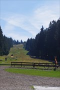 view gallery view gallerySE9 km |  Sommerrodelbahn Erbeskopf - Thalfang, Germany Sommerrodelbahn Erbeskopf - Thalfang, Germany
in Roller Coasters Sommerrodelbahn to the highest point of Rheinland-Pfalz nearby Thalfang, Germany. posted by: dreamhummie location: Rheinland-Pfalz, Germany date approved: 10/03/2018 last visited: 10/08/2018 |
 view gallery view gallery NW9.5 km NW9.5 km
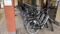
|  Fahrradverleih Eurostrand Resort Moseltal - Leiwen, RP, Germany Fahrradverleih Eurostrand Resort Moseltal - Leiwen, RP, Germany
in Bicycle Rentals Fahrradverleih im Eurostrand Resort Moseltal in Leiwen. posted by: kaschper69 location: Rheinland-Pfalz, Germany date approved: 04/27/2018 last visited: 04/25/2018 |
 view gallery view galleryNW9.5 km |  Arrows Eurostrand Resort Moseltal - Leiwen, RP, Germany Arrows Eurostrand Resort Moseltal - Leiwen, RP, Germany
in Direction and Distance Arrows Arrows at the Eurostrand Resort Moseltal, Leiwen. posted by: kaschper69 location: Rheinland-Pfalz, Germany date approved: 05/01/2018 last visited: 04/25/2018 |
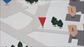 view gallery view galleryNW9.5 km |  Übersichtsplan Eurostrand Resort Moseltal - Leiwen, RP, Germany Übersichtsplan Eurostrand Resort Moseltal - Leiwen, RP, Germany
in 'You Are Here' Maps Map with own Location at the Eurostrand Resort Moseltal at Leiwen. posted by: kaschper69 location: Rheinland-Pfalz, Germany date approved: 04/26/2018 last visited: 04/25/2018 |
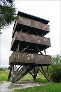 view gallery view gallerySE9.7 km |  NATO Air Defense Radar Tech Site Erbeskopf - Germany NATO Air Defense Radar Tech Site Erbeskopf - Germany
in Abandoned Air Force Radar Sites Former Radar Site at a height of 816 metres (2,677 ft) on top of the Mountain named Erbeskopf in Naturpark Saar-Hunsrück near Hilscheid, Germany. posted by: dreamhummie location: Rheinland-Pfalz, Germany date approved: 10/16/2016 last visited: 09/12/2020 |
 view gallery view gallerySE9.7 km |  Erbeskopf - Hilscheid, Germany Erbeskopf - Hilscheid, Germany
in Geographic High Points Erbeskopf - Hilscheid, the Highest Point in Rhineland-Palatinate, Germany. Elevation 816m. posted by: dreamhummie location: Rheinland-Pfalz, Germany date approved: 10/05/2017 last visited: 09/12/2020 |
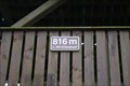 view gallery view gallerySE9.7 km | 816m - Erbeskopf - Hilscheid, Germany in Elevation Signs Elevation Sign, 816m, at the look out tower on top of the Mountain named Erbeskopf in Naturpark Saar-Hunsrück near Hilscheid, Germany. posted by: dreamhummie location: Rheinland-Pfalz, Germany date approved: 10/13/2016 last visited: 09/12/2020 |
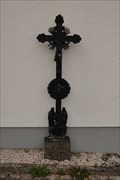
 view gallery view gallerySW10.5 km |  Churchyard Cross - Hinzert, Hinzert-Pölert, Germany Churchyard Cross - Hinzert, Hinzert-Pölert, Germany
in Churchyard Crosses Churchyard Cross located on the cemetery at Alte Kirchstraße 4 in Hinzert, Hinzert-Pölert, Germany. posted by: dreamhummie location: Rheinland-Pfalz, Germany date approved: 01/16/2023 last visited: never |
 view gallery view gallerySW10.5 km | Grabkreuz Hinzert - Hinzert-Pölert, Deutschland in Deutsche Denkmallisten - German Monument Registers Grabkreuz auf dem Kirchhof an der Alte Kirchstraße 4 in Hinzert, Hinzert-Pölert, Deutschland. posted by: dreamhummie location: Rheinland-Pfalz, Germany date approved: 09/14/2022 last visited: never |
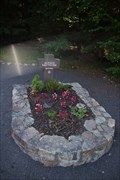
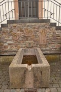 view gallery view gallerySW10.5 km |  Brunnen - Hinzert - Hinzert-Pölert, Germany Brunnen - Hinzert - Hinzert-Pölert, Germany
in Fountains Fountain in front of the Kapelle "St. Johannes der Täufer" at Johannisplatz 2 in Hinzert, Hinzert-Pölert, Germany. posted by: dreamhummie location: Rheinland-Pfalz, Germany date approved: 12/03/2022 last visited: never |
 view gallery view gallerySW10.5 km | Kapelle "St. Johannes der Täufer" Hinzert - Hinzert-Pölert, Deutschland in Deutsche Denkmallisten - German Monument Registers Kapelle "St. Johannes der Täufer" am Johannisplatz 2 in Hinzert, Hinzert-Pölert, Deutschland. posted by: dreamhummie location: Rheinland-Pfalz, Germany date approved: 09/13/2022 last visited: never |
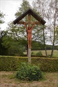
 view gallery view gallerySW10.5 km |  Memorial War-Fallen Son - Hinzert-Pölert, Germany Memorial War-Fallen Son - Hinzert-Pölert, Germany
in World War II Memorials / Monuments Memorial Cross along the Hochwaldstraße between Hinzert and Pölert, Germany. posted by: dreamhummie location: Rheinland-Pfalz, Germany date approved: 01/22/2023 last visited: never |
 view gallery view gallery NE10.6 km NE10.6 km
|  Bank vor der Grauen Ley - Morbach, Rheinland-Pfalz, Germany Bank vor der Grauen Ley - Morbach, Rheinland-Pfalz, Germany
in Artistic Seating Eine schicke Bank, mitten im Wald, vor dem Naturdenkmal "Graue Ley". ***
A bench amidst forest in front of the natural monument "Graue Ley". posted by: dieSulzer location: Rheinland-Pfalz, Germany date approved: 09/17/2016 last visited: 02/04/2017 |
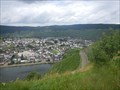 view gallery view gallery N10.6 km N10.6 km
|  Aussichtspunkt Pestkapelle - Minheim, Germany Aussichtspunkt Pestkapelle - Minheim, Germany
in Scenic Roadside Look-Outs On a voyage trough the Mosel vale, stop here at the chapel to get a great view! posted by: Becktracker location: Rheinland-Pfalz, Germany date approved: 04/02/2021 last visited: 07/12/2016 |
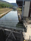 view gallery view galleryW10.6 km |  Schleuse Detzem, Detzem, Germany Schleuse Detzem, Detzem, Germany
in Waterway Locks, Planes and Lifts Eine weitere Schleuse am Fluss Mosel *** The lock is required for ships using the river Mosel posted by: 4spring location: Rheinland-Pfalz, Germany date approved: 10/01/2016 last visited: 09/22/2016 |
|