 view gallery view gallery SW7.2 km SW7.2 km
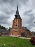
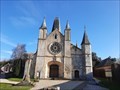
|   Église Saint-Pierre-Saint-Paul - Grémonville, France Église Saint-Pierre-Saint-Paul - Grémonville, France
in Wikipedia Entries [EN] The church, the work of Rouen architect Charles Thibault, was built from 1774 to 1777.
[FR] L'église, oeuvre de l'architecte rouennais Charles Thibault, a été construite de 1774 à 1777. posted by:  pmaupin pmaupin location: Normandie, France date approved: 08/12/2023 last visited: never |
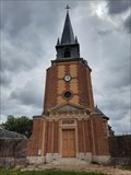
 view gallery view gallerySW7.2 km |  Église Saint-Pierre-Saint-Paul - Grémonville, France Église Saint-Pierre-Saint-Paul - Grémonville, France
in This Old Church [EN] The church, the work of Rouen architect Charles Thibault, was built from 1774 to 1777.
[FR] L'église, oeuvre de l'architecte rouennais Charles Thibault, a été construite de 1774 à 1777. posted by: pmaupin location: Normandie, France date approved: 08/12/2023 last visited: never |
 view gallery view gallerySW7.2 km | Église Saint-Pierre-Saint-Paul - Grémonville, France in Roman Catholic Churches [EN] The church, the work of Rouen architect Charles Thibault, was built from 1774 to 1777.
[FR] L'église, oeuvre de l'architecte rouennais Charles Thibault, a été construite de 1774 à 1777. posted by: pmaupin location: Normandie, France date approved: 08/13/2023 last visited: never |
 view gallery view gallerySW7.2 km |  Église Saint-Pierre-Saint-Paul - Grémonville, France Église Saint-Pierre-Saint-Paul - Grémonville, France
in Monuments Historiques Français [FR] L'église, oeuvre de l'architecte rouennais Charles Thibault, a été construite de 1774 à 1777.
[EN] The church, the work of Rouen architect Charles Thibault, was built from 1774 to 1777. posted by: pmaupin location: Normandie, France date approved: 08/12/2023 last visited: never |
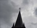
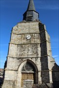
 view gallery view gallerySW7.2 km |  Le Clocher de l'Église Saint-Pierre-Saint-Paul - Grémonville, France Le Clocher de l'Église Saint-Pierre-Saint-Paul - Grémonville, France
in Bell Towers [EN] The church, the work of Rouen architect Charles Thibault, was built from 1774 to 1777.
[FR] L'église, oeuvre de l'architecte rouennais Charles Thibault, a été construite de 1774 à 1777. posted by: pmaupin location: Normandie, France date approved: 08/12/2023 last visited: never |
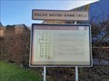
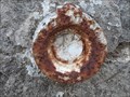
 view gallery view gallerySW7.2 km |  Benchmark - Point géodésique - Église Saint-Pierre-Saint-Paul - Grémonville, France Benchmark - Point géodésique - Église Saint-Pierre-Saint-Paul - Grémonville, France
in French Benchmarks Repère géodésique du point 1, sur le centre de la croix du clocher avec un Azimut de la prise de vue égal à 148 gr. posted by: pmaupin location: Normandie, France date approved: 08/12/2023 last visited: never |
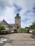
 view gallery view gallery N15.4 km N15.4 km
| Église Notre-Dame - Le Bourg-Dun, France in Monuments Historiques Français [FR] L’Eglise du Bourg-Dun fut construite en l’an 1015, sur les ruines d’une ancienne abbaye détruite au IXème siècle lors d’une incursion normande.
[EN] The Bourg-Dun Church was built in the year 1015, on the ruins of an old abbey destroyed in the 9th century during a Norman incursion. posted by: pmaupin location: Normandie, France date approved: 02/26/2021 last visited: 06/03/2023 |
 view gallery view galleryN15.4 km | ") Église Notre-Dame - Le Bourg-Dun, France Église Notre-Dame - Le Bourg-Dun, France
in Histoires de France (French historical markers) [FR] L’Eglise du Bourg-Dun fut construite en l’an 1015, sur les ruines d’une ancienne abbaye détruite au IXème siècle lors d’une incursion normande. [EN] The Bourg-Dun Church was built in the year 1015, on the ruins of an old abbey destroyed in the 9th century during a Norman incursion. posted by: pmaupin location: Normandie, France date approved: 03/06/2021 last visited: 06/03/2023 |
 view gallery view galleryN15.4 km | Église Notre-Dame - Le Bourg-Dun, France in Roman Catholic Churches [EN] The Bourg-Dun Church was built in the year 1015, on the ruins of an old abbey destroyed in the 9th century during a Norman incursion. [FR] L’Eglise du Bourg-Dun fut construite en l’an 1015, sur les ruines d’une ancienne abbaye détruite au IXème siècle lors d’une incursion normande. posted by: pmaupin location: Normandie, France date approved: 02/27/2021 last visited: 06/03/2023 |
 view gallery view galleryN15.4 km | Église Notre-Dame - Le Bourg-Dun, France in This Old Church [EN] The Bourg-Dun Church was built in the year 1015, on the ruins of an old abbey destroyed in the 9th century during a Norman incursion. [FR] L’Eglise du Bourg-Dun fut construite en l’an 1015, sur les ruines d’une ancienne abbaye détruite au IXème siècle lors d’une incursion normande. posted by: pmaupin location: Normandie, France date approved: 02/26/2021 last visited: 06/03/2023 |
 view gallery view galleryN15.4 km |  Vous Etes Ici : Église Notre-Dame - Le Bourg-Dun, France Vous Etes Ici : Église Notre-Dame - Le Bourg-Dun, France
in 'You Are Here' Maps [EN] The indications "you are here" can be found on a panel to the right of Notre-Dame church.
[FR] Les indications "vous êtes ici" se trouve sur un panneau situé à droite de l'église Notre-Dame. posted by: pmaupin location: Normandie, France date approved: 03/06/2021 last visited: 02/24/2021 |
 view gallery view galleryN15.4 km |  Église Notre-Dame - Le Bourg-Dun, France Église Notre-Dame - Le Bourg-Dun, France
in Medieval Churches [EN] The Bourg-Dun Church was built in the year 1015, on the ruins of an old abbey destroyed in the 9th century during a Norman incursion.
[FR] L’Eglise du Bourg-Dun fut construite en l’an 1015, sur les ruines d’une ancienne abbaye détruite au IXème siècle lors d’une incursion normande. posted by: pmaupin location: Normandie, France date approved: 02/26/2021 last visited: 06/03/2023 |
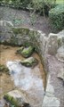
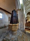 view gallery view galleryN15.4 km |  Les Fonts Baptismaux - Église Notre-Dame - Le Bourg-Dun, France Les Fonts Baptismaux - Église Notre-Dame - Le Bourg-Dun, France
in Stone Church Artefacts [EN] The baptismal fonts of the Church of Notre-Dame date from the 16th century.
[FR] Les Fonts baptismaux de l'Église Notre-Dame datent du 16ème siècle. posted by: pmaupin location: Normandie, France date approved: 03/06/2021 last visited: 02/24/2021 |
 view gallery view galleryN15.4 km | Benchmark - Eglise Notre-Dame - Le Bourg-Dun, France in French Benchmarks Le repère Cylindrique du Nivellement Général se situe sur le soubassement du mur de façade nord-ouest de la tourelle à l'angle nord-ouest du bâtiment. posted by: pmaupin location: Normandie, France date approved: 03/06/2021 last visited: 02/24/2021 |
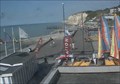
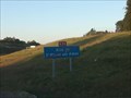 view gallery view gallerySW16.7 km |  Aire de Saint-Martin aux Arbres Sud - A29 - Yerville, France Aire de Saint-Martin aux Arbres Sud - A29 - Yerville, France
in Highway Rest Areas [EN] Rest area on the A29 motorway towards Calais (between Le Havre and Calais).
[FR] Aire de repos sur l'autoroute A29 en direction de Calais (entre Le Havre et Calais). posted by: pmaupin location: Normandie, France date approved: 09/19/2020 last visited: 07/21/2020 |
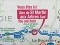 view gallery view gallerySW16.7 km | You Are Here - Aire de Saint-Martin aux Arbres Sud - Yerville, France in 'You Are Here' Maps [EN] The indications "you are here" can be found on a sign located on the Saint-Martin aux Arbres Sud motorway service area.
[FR] Les indications "vous êtes ici" se trouve sur un panneau situé sur l'aire d'autoroute de Saint-Martin aux Arbres Sud. posted by: pmaupin location: Normandie, France date approved: 08/26/2020 last visited: 07/21/2020 |
 view gallery view galleryN16.9 km |  ORIGIN - La Veules - Veules -les-Roses, France ORIGIN - La Veules - Veules -les-Roses, France
in River Origins, Destinations and Confluences [EN] La Veules, which flows into the Channel, is the smallest coastal river in France.
[FR] La Veules qui se jette dans la Manche, est le fleuve côtier le plus petit de France. posted by: pmaupin location: Normandie, France date approved: 07/29/2017 last visited: 06/03/2023 |
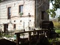 view gallery view galleryN17.2 km |  Moulin des aïeux - Veules les roses, France Moulin des aïeux - Veules les roses, France
in Water Mills FR - Moulin à blé, seul à présenter encore un équipement complet.
EN - Wheat mill, the only one to present complete equipment. posted by: geotrouvtou59 location: Normandie, France date approved: 04/05/2020 last visited: 01/30/2023 |
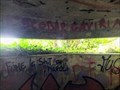 view gallery view galleryN17.9 km |  WWII relicts - Bunker in Veules-les-Roses WWII relicts - Bunker in Veules-les-Roses
in World War II Sites Freely accessible bunker. posted by: GEOrgCACHING location: Normandie, France date approved: 06/05/2023 last visited: never |
 view gallery view galleryN17.9 km |  Un petit fleuve tranquille. Un petit fleuve tranquille.
in Web Cameras Joli village Normand sur la côte d'Albatre. Plage de galets à marée haute, mais deux heures après on aperçoit le sable fin. Pretty village on the Albâtre coast. Pebble beach at high tide but two hours afterwards, one sees fine sand. posted by:  Gendarmenry Gendarmenry location: France date approved: 07/10/2010 last visited: 06/03/2023 |
 view gallery view gallery W19 km W19 km
| Eglise Saint-Martin - Cany-Barville, France in Medieval Churches [EN] Dated at the end of the 3rd century, the church continued to be rebuilt in the 13th, 16th and 19th centuries.
[FR] Datée de la fin du 3ème siècle, l’église ne cessa d’être reconstruite, au 13ème, 16ème et 19 ème siècle. posted by: pmaupin location: Normandie, France date approved: 03/07/2021 last visited: 02/24/2021 |
 view gallery view galleryW19 km | Eglise Saint-Martin - Cany-Barville, France in Roman Catholic Churches [EN] Dated at the end of the 3rd century, the church continued to be rebuilt in the 13th, 16th and 19th centuries. [FR] Datée de la fin du 3ème siècle, l’église ne cessa d’être reconstruite, au 13ème, 16ème et 19 ème siècle. posted by: pmaupin location: Normandie, France date approved: 03/08/2021 last visited: 02/24/2021 |
 view gallery view galleryW19 km | Eglise Saint-Martin - Cany-Barville, France in This Old Church [EN] Dated at the end of the 3rd century, the church continued to be rebuilt in the 13th, 16th and 19th centuries. [FR] Datée de la fin du 3ème siècle, l’église ne cessa d’être reconstruite, au 13ème, 16ème et 19 ème siècle. posted by: pmaupin location: Normandie, France date approved: 03/07/2021 last visited: 02/24/2021 |
 view gallery view galleryW19 km | Eglise Saint-Martin - Cany-Barville, France in Monuments Historiques Français [FR] Datée de la fin du 3ème siècle, l’église ne cessa d’être reconstruite, au 13ème, 16ème et 19 ème siècle.
[EN] Dated at the end of the 3rd century, the church continued to be rebuilt in the 13th, 16th and 19th centuries. posted by: pmaupin location: Normandie, France date approved: 03/07/2021 last visited: 02/24/2021 |
 view gallery view galleryN21.7 km |  Phare d'Ailly - Sainte-Marguerite-sur-Mer (Seine-Maritime), France Phare d'Ailly - Sainte-Marguerite-sur-Mer (Seine-Maritime), France
in Coastal Lighthouses [FR] Les travaux débutent en 1951. Il est allumé en janvier 1953. [EN] Construction began in 1951. It was lit in January, 1953. posted by: RakeInTheCache location: Normandie, France date approved: 07/04/2021 last visited: 06/02/2023 |
|