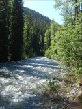
 view gallery view gallery NE4.5 km NE4.5 km
|   E.C. Manning Provincial Park - British Columbia E.C. Manning Provincial Park - British Columbia
in State/Provincial Parks Very large provincial park with something for everyone. posted by:  gypsie2 gypsie2 location: British Columbia, Canada date approved: 10/22/2011 last visited: 07/01/2002 |
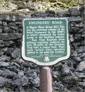 view gallery view galleryNE5.6 km |  Dewdney Trail - Manning Park, BC Dewdney Trail - Manning Park, BC
in Wagon Roads and Trails "Engineers Road" section of the Dewdney Trail. posted by: gypsie2 location: British Columbia, Canada date approved: 08/08/2011 last visited: 08/21/2022 |
 view gallery view galleryNE5.6 km |  Engineers Road, Manning Park, BC Engineers Road, Manning Park, BC
in British Columbia Heritage Markers Along Highway 3 in Manning Provincial Park. posted by: gypsie2 location: British Columbia, Canada date approved: 07/27/2011 last visited: 08/21/2022 |
 view gallery view gallery N5.6 km N5.6 km
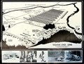
| Tashme Japanese Canadian Internment Camp 1942 - 1946 - Sunshine Valley, BC in British Columbia Heritage Markers Upon entering the Sunshine Valley community from Highway 3, one spies a BC Stop of Interest marker. Further along, one will encounter a more comprehensive marker at the Tashme Museum. posted by: ScroogieII location: British Columbia, Canada date approved: 06/13/2020 last visited: 08/07/2019 |
 view gallery view galleryN5.6 km |  Tashme Japanese-Canadian Internment Camp - Sunshine Valley, BC Tashme Japanese-Canadian Internment Camp - Sunshine Valley, BC
in WWII Prisoner of War Camps Upon entering the Sunshine Valley community from Highway 3, one spies a BC Stop of Interest marker. Further along, one will encounter a more comprehensive marker at the Tashme Museum. posted by: ScroogieII location: British Columbia, Canada date approved: 09/21/2020 last visited: 08/07/2019 |
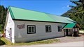
 view gallery view galleryN5.6 km |  Tashme Museum - Sunshine Valley, BC Tashme Museum - Sunshine Valley, BC
in War and Military Museums Upon entering the Sunshine Valley community from Highway 3, one spies a BC Stop of Interest marker. Further along, one will encounter a more comprehensive marker at the Tashme Museum. posted by: ScroogieII location: British Columbia, Canada date approved: 06/14/2020 last visited: 08/07/2019 |
 view gallery view galleryN5.6 km |  Tashme Museum - Sunshine Valley, BC Tashme Museum - Sunshine Valley, BC
in Official Local Tourism Attractions Upon entering the Sunshine Valley community from Highway 3, one spies a BC Stop of Interest marker. Further along, one will encounter a more comprehensive marker at the Tashme Museum. posted by: ScroogieII location: British Columbia, Canada date approved: 06/15/2020 last visited: 08/07/2019 |
 view gallery view galleryN5.6 km |  LARGEST Japanese Internment Camp in BC - Sunshine Valley, BC LARGEST Japanese Internment Camp in BC - Sunshine Valley, BC
in Superlatives Upon entering the Sunshine Valley community from Highway 3, one spies a BC Stop of Interest marker. Further along, one will encounter a more comprehensive marker at the Tashme Museum. posted by: ScroogieII location: British Columbia, Canada date approved: 06/14/2020 last visited: 08/07/2019 |
 view gallery view galleryN5.6 km |  Sunshine Valley, BC, Canada Sunshine Valley, BC, Canada
in Wikipedia Entries Upon entering the Sunshine Valley community from Highway 3, one spies a BC Stop of Interest marker. Further along, one will encounter a more comprehensive marker at the Tashme Museum. posted by: ScroogieII location: British Columbia, Canada date approved: 06/14/2020 last visited: 08/07/2019 |
 view gallery view galleryN5.6 km |  Canada's largest Japanese-Canadian internment camp remembered at museum Canada's largest Japanese-Canadian internment camp remembered at museum
in News Article Locations Upon entering the Sunshine Valley community from Highway 3, one spies a BC Stop of Interest marker. Further along, one will encounter a more comprehensive marker at the Tashme Museum. posted by: ScroogieII location: British Columbia, Canada date approved: 06/14/2020 last visited: 08/07/2019 |
 view gallery view galleryN5.6 km |  Tashme Museum - Sunshine Valley, BC Tashme Museum - Sunshine Valley, BC
in History Museums Upon entering the Sunshine Valley community from Highway 3, one spies a BC Stop of Interest marker. Further along, one will encounter a more comprehensive marker at the Tashme Museum. posted by: ScroogieII location: British Columbia, Canada date approved: 06/15/2020 last visited: 08/07/2019 |
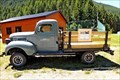 view gallery view galleryN5.8 km |  Dodge WD15 3/4 Ton Pickup - Tashme Museum - Sunshine Valley, BC Dodge WD15 3/4 Ton Pickup - Tashme Museum - Sunshine Valley, BC
in Permanent Car Displays At the Tashme Museum in Sunshine Valley one will find a wartime Dodge pickup on display. posted by: ScroogieII location: British Columbia, Canada date approved: 06/14/2020 last visited: 09/18/2020 |
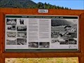
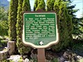 view gallery view galleryN6.1 km | Tashme - Sunshine Valley, BC in British Columbia Heritage Markers To the side of Sumallo River Road, leading to the Tashme Museum and site of the Tashme Detention Camp is this BC Stop of Interest marker. posted by: ScroogieII location: British Columbia, Canada date approved: 06/13/2020 last visited: 09/17/2020 |
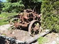 view gallery view galleryN6.1 km |  McCormick Deering 15-30 - Sunshine Valley, BC McCormick Deering 15-30 - Sunshine Valley, BC
in Old Tractors To the side of Sumallo River Road, leading to the Tashme Museum and site of the Tashme Detention Camp, is this BC Stop of Interest marker. Hiding behind those cedars is most of a rusting McCormick Deering 15-30. posted by: ScroogieII location: British Columbia, Canada date approved: 06/16/2020 last visited: 09/18/2020 |
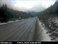 view gallery view galleryN9 km |  Hope Slide Webcam - Hope, BC Hope Slide Webcam - Hope, BC
in Web Cameras Fourteen kilometres southeast of exit 173 for Hope is where one will find the Hope Slide and this webcam. posted by: T0SHEA location: British Columbia, Canada date approved: 02/08/2016 last visited: never |
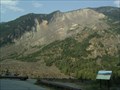
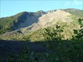 view gallery view galleryN9 km | Hope Slide - Hope, British Columbia, Canada in Wikipedia Entries Hope Slide is located 12 kilometres southeast of Hope on the Crowsnest Highway. There is a parking area for viewing the slide. posted by: T0SHEA location: British Columbia, Canada date approved: 12/11/2012 last visited: 08/21/2022 |
 view gallery view galleryN9 km |  Victims of the Hope Slide — Hope Slide, BC Victims of the Hope Slide — Hope Slide, BC
in Citizen Memorials An earthquake in 1965 triggered a massive landslide that brought down a side of mountain. At that moment two cars were travelling along the Crowsnest Highway and four lives were lost. posted by:  Dunbar Loop Dunbar Loop location: British Columbia, Canada date approved: 04/03/2012 last visited: 08/21/2022 |
 view gallery view galleryN9.2 km |  The Hope Slide - Hope, BC Canada The Hope Slide - Hope, BC Canada
in Satellite Imagery Oddities The largest land side in Western Canada. posted by: bcrockcrawler, xstitcher, & BMXer location: British Columbia, Canada date approved: 07/25/2010 last visited: 08/21/2022 |
 view gallery view galleryN9.2 km |  The Hope Slide - Hope, BC Canada The Hope Slide - Hope, BC Canada
in Places of Geologic Significance The largest land side in Western Canada. posted by: bcrockcrawler, xstitcher, & BMXer location: British Columbia, Canada date approved: 07/22/2010 last visited: 08/21/2022 |
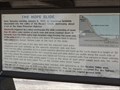 view gallery view galleryN9.2 km |  Hope Slide - Hope, British Columbia Hope Slide - Hope, British Columbia
in Signs of History Hope Slide sign of history is located in the viewing area overlooking the slide area. There is a large parking area and EV charging stations. posted by: T0SHEA location: British Columbia, Canada date approved: 07/10/2019 last visited: 08/21/2022 |
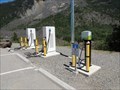 view gallery view galleryN9.2 km |  Hope Slide Viewpoint - Hope, British Columbia Canada Hope Slide Viewpoint - Hope, British Columbia Canada
in Electric Car Charging Stations Hope Slide Viewpoint overlooks the slide area. There is a large parking area and EV charging stations. As you enter the rest area off the Crowsnet Hwy. there is a paved road that ascends up a hill were the viewing area is located There is sign. posted by: T0SHEA location: British Columbia, Canada date approved: 07/11/2019 last visited: 08/21/2022 |
 view gallery view galleryN9.2 km |  Hope Slide Viewpoint - Hope, BC Hope Slide Viewpoint - Hope, BC
in Scenic Roadside Look-Outs A big viewpoint for one of the largest landslides in Western Canada. posted by: bcrockcrawler, xstitcher, & BMXer location: British Columbia, Canada date approved: 07/24/2010 last visited: 08/21/2022 |
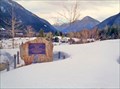
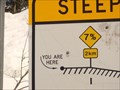 view gallery view galleryN9.2 km |  "You Are Here" Steep Grades Ahead — Hope Slide, BC "You Are Here" Steep Grades Ahead — Hope Slide, BC
in 'You Are Here' Maps As trucks begin to approach Hope they are asked to stop to check their brakes. At this pull off is a sign showing 7% descent over 6 kilometers with a "you are here" indicator. posted by: Dunbar Loop location: British Columbia, Canada date approved: 04/03/2012 last visited: never |
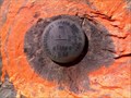 view gallery view galleryN9.7 km |  83C010 83C010
in Canadian Benchmarks Brass Cap posted by: tubby and location: British Columbia, Canada date approved: 07/21/2010 last visited: never |
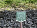
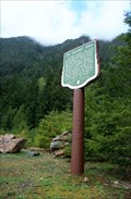 view gallery view gallery E12.1 km E12.1 km
| The Dewdney Trail — Cascade Recreation Area, BC in British Columbia Heritage Markers The Dewdney Trail was developed through the 1860s to provide an all-British Columbia route from the Interior of the colony to water access on the Pacific Ocean. posted by: Dunbar Loop location: British Columbia, Canada date approved: 06/04/2013 last visited: never |
|