 view gallery view gallery E1.4 km E1.4 km
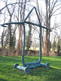
|   La Caravane Passe La Caravane Passe
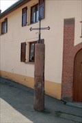
in Abstract Public Sculptures [FR] Une sculpture en plein coeur du Kochersberg, secteur de l'Alsace, près de Strasbourg. L'oeuvre est de Michel Déjean.
[ENG] A sculpture in the Kochersberg area of the Alsace Region, near Strasbourg. This sculpture is by Michel Déjean. posted by:  Chris777 Chris777 location: Grand-Est, France date approved: 04/02/2007 last visited: 11/14/2010 |
 view gallery view gallery N2.3 km N2.3 km
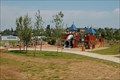
|  Aire de jeux - Truchtersheim, France Aire de jeux - Truchtersheim, France
in Public Playgrounds [FR] Aire de jeux près du stade de football de Truchtersheim.
[ENG] Playground close to the soccer field of Truchtersheim. posted by: Chris777 location: Grand-Est, France date approved: 03/10/2008 last visited: 06/27/2008 |
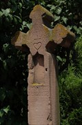 view gallery view galleryN3.4 km |  Croix Hans Dosman - Truchtersheim, France Croix Hans Dosman - Truchtersheim, France
in Christian Crosses [FR] Croix située dans le village de Truchtersheim
[ENG] Cross located in the village of Truchtersheim. posted by: Chris777 location: Grand-Est, France date approved: 03/08/2008 last visited: 06/10/2007 |
 view gallery view gallery NW3.4 km NW3.4 km
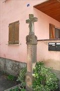
| Croix Lehmann-Dossmann - Kleinfrankenheim, France in Christian Crosses [FR] Croix avec niche de 1756 dans le village de Kleinfrankenheim, dans le Kochersberg (Bas-Rhin, Alsace, France)
[ENG] Cross with niche of 1756 in the village of Kleinfrankenheim, Kochersberg (Bas-Rhin, Alsace, France) posted by: Chris777 location: Grand-Est, France date approved: 06/10/2007 last visited: 11/14/2010 |
 view gallery view galleryNW3.5 km | "Colonne de la Peste" - Schnersheim, France in Christian Crosses [FR]Croix du 16e siècle dans le Kochersberg, à Schnersheim.
[ENG]Cross of the 16th century in Kochersberg area, in Schnersheim. posted by: Chris777 location: Grand-Est, France date approved: 06/24/2007 last visited: 11/14/2010 |
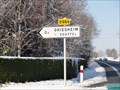 view gallery view galleryE5.6 km |  Départementale 666 - Griesheim s/ Souffel, France Départementale 666 - Griesheim s/ Souffel, France
in 666 Sightings [FR] Le numéro de la départementale 666 à l'entrée de Griesheim sur Souffel.
[EN] The number of the 666 road at the entrance of Griesheim sur Souffel. posted by: Chris777 location: Grand-Est, France date approved: 11/30/2010 last visited: 10/27/2021 |
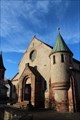
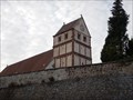 view gallery view galleryNW7.9 km |  Église Saint-Maurice - Willgottheim, France Église Saint-Maurice - Willgottheim, France
in Monuments Historiques Français Classée monument historique par arrêté du 3 juillet 1900, seule la tour-chœur subsiste de l'église romane construite vers 1170-1180. Elle se compose de quatre niveaux ornés, sauf le dernier, de frises d'arceaux et de lésènes. Le premier niveau est en pierre de taille tandis que les suivants sont en moellons recouverts d'enduit avec chaînage d'angle en pierre de taille. posted by: Epiméthée location: Grand-Est, France date approved: 11/06/2014 last visited: 11/05/2014 |
 view gallery view gallery S8.2 km S8.2 km
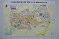
|  Holtzheim Miniatures - France Holtzheim Miniatures - France
in 'You Are Here' Maps A map showing the location of the miniature landmarks that can be found in this town. posted by: rjm1 location: Grand-Est, France date approved: 10/02/2010 last visited: 05/06/2009 |
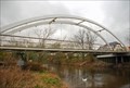 view gallery view galleryS8.5 km |  Passerelle de la Bruche - Holtzheim, France Passerelle de la Bruche - Holtzheim, France
in Pedestrian Suspension Bridges Passerelle enjambant la Bruche et reliant le centre du village de Holtzheim aux nouveaux lotissements construits de l'autre côté de la rivière. posted by: Chris777 location: Grand-Est, France date approved: 03/04/2008 last visited: 01/23/2013 |
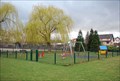 view gallery view galleryS8.9 km | Place de jeux - Holtzheim, France in Public Playgrounds [FR] Place de jeux le long de la Bruche, rivière traversant Holtzheim.
[ENG] Playground close to the Bruche river crossing the village of Holtzheim. posted by: Chris777 location: Grand-Est, France date approved: 03/10/2008 last visited: 01/23/2013 |
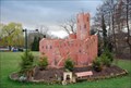 view gallery view galleryS8.9 km |  Château d'Ortenbourg - Holtzheim, France Château d'Ortenbourg - Holtzheim, France
in Exact Replicas [FR] Réplique du château d'Ortenbourg au centre du village de Holtzheim.
[ENG] Replica from the Ortenbourg castle in the center of Holtzheim. posted by: Chris777 location: Grand-Est, France date approved: 03/08/2008 last visited: 01/23/2013 |
 view gallery view gallery NE9.5 km NE9.5 km
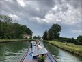
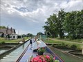
|  Écluse 48 (Rhine slope) - Canal de la Marne au Rhin (eastern section) - Vendenheim - France Écluse 48 (Rhine slope) - Canal de la Marne au Rhin (eastern section) - Vendenheim - France
in Waterway Locks, Planes and Lifts This is lock number 48 on the Rhine slope of the Canal de la Marne au Rhin (eastern section). posted by: ntpayne location: Grand-Est, France date approved: 08/15/2022 last visited: never |
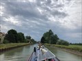
 view gallery view galleryNE9.7 km | Écluse 47 (Rhine slope) - Canal de la Marne au Rhin (eastern section) - Eckwersheim - France in Waterway Locks, Planes and Lifts This is lock number 47 on the Rhine slope of the Canal de la Marne au Rhin (eastern section). posted by: ntpayne location: Grand-Est, France date approved: 08/11/2022 last visited: never |
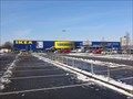 view gallery view galleryE10.3 km |  IKEA Strasbourg - France IKEA Strasbourg - France
in IKEA [FR] Magasin IKEA de Strasbourg
[EN] IKEA store of Strasbourg posted by: Chris777 location: Grand-Est, France date approved: 11/30/2010 last visited: 04/05/2013 |
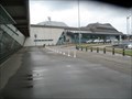 view gallery view galleryS10.5 km |  Aéroport de Strasbourg-Entzheim - Entzheeim, France Aéroport de Strasbourg-Entzheim - Entzheeim, France
in Inside Airports FR - L’aéroport de Strasbourg-Entzheim est un aéroport français situé sur le territoire des communes d'Entzheim.
EN - Strasbourg-Entzheim Airport is a French airport located on the territory of the municipalities of Entzheim. posted by: geotrouvtou59 location: Grand-Est, France date approved: 12/01/2020 last visited: 12/02/2020 |
 view gallery view galleryE10.6 km | Écluse 49 (Rhine slope) - Canal de la Marne au Rhin (eastern section) - Reichstett - France in Waterway Locks, Planes and Lifts This is lock number 49 on the Rhine slope of the Canal de la Marne au Rhin (eastern section). posted by: ntpayne location: Grand-Est, France date approved: 08/15/2022 last visited: never |
 view gallery view gallery SW10.8 km SW10.8 km
|  Eglise Saint-Materne - Avolsheim, France Eglise Saint-Materne - Avolsheim, France
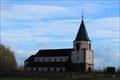
in This Old Church [EN] The Church Saint-Materne d'Avolsheim is built from 1907 until 1911. [FR] L'Eglise Saint-Materne d'Avolsheim est construite de 1907 jusqu'en 1911. posted by: pmaupin location: Grand-Est, France date approved: 12/11/2017 last visited: 11/29/2017 |
 view gallery view gallerySW10.8 km | Eglise Saint-Materne - Avolsheim, France in Roman Catholic Churches [EN] The Church Saint-Materne d'Avolsheim is built from 1907 until 1911.
[FR] L'Eglise Saint-Materne d'Avolsheim est construite de 1907 jusqu'en 1911. posted by: pmaupin location: Grand-Est, France date approved: 12/10/2017 last visited: 11/29/2017 |
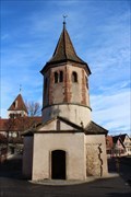
 view gallery view gallerySW10.8 km |  Chapelle Saint-Ulrich - Avolsheim, France Chapelle Saint-Ulrich - Avolsheim, France
in Wikipedia Entries [EN] The St. Ulrich chapel, which stands in the middle of the village is distinguished by its octagonal Romanesque bell tower.
[FR] La chapelle Saint-Ulrich, qui s’élève au milieu du village se signale par son clocher octogonal roman. posted by: pmaupin location: Grand-Est, France date approved: 12/04/2017 last visited: 08/13/2012 |
 view gallery view gallerySW10.8 km | Chapelle Saint-Ulrich - Avolsheim, France in Monuments Historiques Français [FR] La chapelle Saint-Ulrich, qui s’élève au milieu du village se signale par son clocher octogonal roman.
[EN] The St. Ulrich chapel, which stands in the middle of the village is distinguished by its octagonal Romanesque bell tower. posted by: pmaupin location: Grand-Est, France date approved: 12/09/2017 last visited: 08/13/2012 |
 view gallery view gallerySW10.8 km |  Chapelle Saint-Ulrich - Avolsheim (Bas-Rhin), France Chapelle Saint-Ulrich - Avolsheim (Bas-Rhin), France
in Romanesque Architecture [EN] The St. Ulrich chapel, which stands in the middle of the village is distinguished by its octagonal Romanesque bell tower. [FR] La chapelle Saint-Ulrich, qui s’élève au milieu du village se signale par son clocher octogonal roman. posted by: pmaupin location: Grand-Est, France date approved: 07/21/2018 last visited: 08/13/2012 |
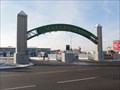 view gallery view galleryE10.8 km |  Arche du Marché Gare - Strasbourg, France Arche du Marché Gare - Strasbourg, France
in Freestanding Arches [FR] Arche à l'entrée du Marché Gare de Strasbourg
[EN] Arch at the entrance of the Marché Gare of Strasbourg posted by: Chris777 location: Grand-Est, France date approved: 11/30/2010 last visited: 01/22/2013 |
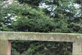 view gallery view gallerySW10.8 km |  Banc-reposoir d'Alsace - 1854 - Avolsheim, France Banc-reposoir d'Alsace - 1854 - Avolsheim, France
in Dated Architectural Structures Multifarious [EN] A bench-rest on the rural road called "Kirchweg", facing a Bildstock.
[FR] Un banc-reposoir sur le chemin rural dit "Kirchweg", face à un Bildstock posted by: pmaupin location: Grand-Est, France date approved: 12/07/2017 last visited: 11/29/2017 |
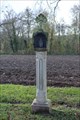 view gallery view gallerySW10.8 km |  Bildstock - Avolsheim, France Bildstock - Avolsheim, France
in Wayside shrines [EN] A Bildstock on the rural road called "Kirchweg", facing a bench.
[FR] Un Bildstock sur le chemin rural dit "Kirchweg", face à un banc reposoir. posted by: pmaupin location: Grand-Est, France date approved: 12/07/2017 last visited: 11/29/2017 |
 view gallery view gallerySW10.9 km | Église Saint-Pierre dite "Dompeter" - Avolsheim, France in Wikipedia Entries [EN] The St. Peter's Church called Dompeter or more simply called the Dompeter is the former parish church of Molsheim.
[FR]L'église Saint-Pierre dite Dompeter ou plus simplement appelée le Dompeter est l'ancienne église paroissiale de Molsheim. posted by: pmaupin location: Grand-Est, France date approved: 12/04/2017 last visited: 01/28/2023 |
|