 view gallery view gallery W0.6 km W0.6 km
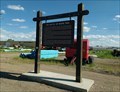
|   The Battle of Bears Paw - Chinook, MT The Battle of Bears Paw - Chinook, MT
in Montana Historical Markers Just west of Chinook, describes a battle that took place some 20 miles to the south posted by:  Bon Echo Bon Echo location: Montana date approved: 07/23/2018 last visited: never |
 view gallery view gallery N5 km N5 km
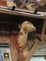
|  Bar with Two-Headed Calf - Columbus, Montana: Bar with Two-Headed Calf - Columbus, Montana:
in Roadside Attractions This two-headed calf is in the New Atlas Bar located at 528 E. Pike Avenue in downtown Columbus. posted by:  T0SHEA T0SHEA location: Montana date approved: 02/24/2018 last visited: never |
 view gallery view gallery S24.1 km S24.1 km
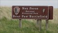
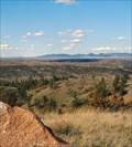
| ") Nez Perce National Historical Park / Bear Paw Battlefield - Chinook, MT Nez Perce National Historical Park / Bear Paw Battlefield - Chinook, MT
in National Parks (U.S.) Located 15 miles south of Chinook, MT on Highway 240, the Bear Paw Battlefield commemorates the final battle of the Nez Perce War of 1877.
posted by: Martin 5 location: Montana date approved: 02/19/2009 last visited: never |
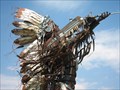
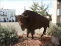 view gallery view galleryW33.2 km |  Buffalo in Havre, MT Buffalo in Havre, MT
in Figurative Public Sculpture This metal scuplture of a "Buffalo" is located in a park in Havre, MT along U. S. Hwy 2. No information is posted about the Buffalo. posted by: The-DuHawks location: Montana date approved: 09/17/2008 last visited: 05/26/2014 |
 view gallery view gallery E33.6 km E33.6 km
|  Ft. Belknap Reservation, Gros Ventre & Assiniboine - Montana, USA Ft. Belknap Reservation, Gros Ventre & Assiniboine - Montana, USA
in Nations Within Nations Gros Ventre & Assiniboine - Nakoda posted by: CerealBoxMonsters location: Montana date approved: 07/30/2009 last visited: never |
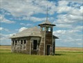 view gallery view galleryW49.9 km |  Burnham School - Burnham, MT Burnham School - Burnham, MT
in One-Room Schoolhouses Not quite abandoned but certainly not in use posted by: Bon Echo location: Montana date approved: 12/07/2018 last visited: never |
 view gallery view gallery SW65.3 km SW65.3 km
| Rocky Boy's Reservation, Chippewa-Cree - Montana, USA in Nations Within Nations Chippewa-Cree - Tansi posted by: CerealBoxMonsters location: Montana date approved: 07/30/2009 last visited: never |
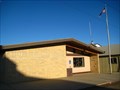
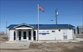 view gallery view galleryE76 km |  Dodson, Montana 59524 Dodson, Montana 59524
in U.S. Post Offices Newer PO in a small town posted by: ZenPanda location: Montana date approved: 11/05/2014 last visited: 10/03/2014 |
 view gallery view gallerySW79.7 km | Big Sandy, MT 59520 in U.S. Post Offices This Post Office serves the town of Big Sandy and its surrounding community of approximately 1,000 people. posted by: CerealBoxMonsters location: Montana date approved: 10/26/2009 last visited: 05/22/2010 |
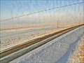 view gallery view gallery SE83.8 km SE83.8 km
|  Hays Site - Hays, MT Hays Site - Hays, MT
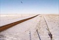
in Web Cameras This is one of 73 (as of January 2017) Road Weather Information System camera sites operated by the Montana Department of Transportation to aid motorists as they make their way across BIG SKY Country. posted by: T0SHEA location: Montana date approved: 01/27/2017 last visited: never |
 view gallery view gallerySE91.6 km |  Zortman - The Friendliest Little Town in Montana Zortman - The Friendliest Little Town in Montana
in Welcome Signs Zortman, a tiny hamlet in eastern Montana, still clings to life, for no obvious reason. posted by: T0SHEA location: Montana date approved: 06/21/2017 last visited: never |
 view gallery view gallerySE91.6 km |  Zortman, Montana, USA Zortman, Montana, USA
in 'Z' Welcome Signs Zortman, a tiny hamlet in eastern Montana, appears to be the answer to the question: "How far would you go for a new category?" posted by: T0SHEA location: Montana date approved: 06/19/2017 last visited: never |
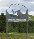 view gallery view gallerySE91.9 km |  Zortman Cemetery - Zortman, Montana Zortman Cemetery - Zortman, Montana
in Worldwide Cemeteries If you want an adventure, Zortman Cemetery is the place to visit. Must caution: do not attempt a visit during the rainy or winter seasons. posted by: T0SHEA location: Montana date approved: 01/05/2018 last visited: never |
 view gallery view galleryN96.6 km |  NWMP Trail Marker NWMP Trail Marker
in Saskatchewan Historical Markers Located on grid road access to Cypress Lake campground. posted by: Altima Voyageur location: Saskatchewan, Canada date approved: 09/25/2013 last visited: never |
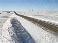
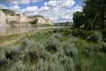 view gallery view gallerySW97.2 km |  The White Cliffs: Upper Missouri National Wild and Scenic River - MT The White Cliffs: Upper Missouri National Wild and Scenic River - MT
in National Wild and Scenic Rivers The Upper Missouri River is one of the premier float trips in the Unites States; running for 149 miles through a spectacular prairie canyon of north-central Montana. The White Cliffs were visited by Lewis & Clark on 31 May, 1805. posted by: CerealBoxMonsters location: Montana date approved: 07/21/2009 last visited: never |
 view gallery view gallerySE98.2 km | Malta North Web Camera - Malta, MT in Web Cameras This is one of 73 (as of January 2017) Road Weather Information System camera sites operated by the Montana Department of Transportation to aid motorists as they make their way across BIG SKY Country. posted by: T0SHEA location: Montana date approved: 02/07/2017 last visited: never |
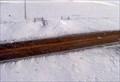 view gallery view gallerySE98.2 km | Malta Roadway Web Camera - Malta, MT in Web Cameras This is one of 73 (as of January 2017) Road Weather Information System camera sites operated by the Montana Department of Transportation to aid motorists as they make their way across BIG SKY Country. posted by: T0SHEA location: Montana date approved: 02/07/2017 last visited: never |
 view gallery view gallerySE98.2 km | Malta South Web Camera - Malta, MT in Web Cameras This is one of 73 (as of January 2017) Road Weather Information System camera sites operated by the Montana Department of Transportation to aid motorists as they make their way across BIG SKY Country. posted by: T0SHEA location: Montana date approved: 02/07/2017 last visited: never |
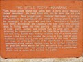 view gallery view gallerySE99.3 km | The Little Rocky Mountains - Zortman, MT in Montana Historical Markers Along Highway 191 in north central Montana, at the junction with Highway 66 are a pair of Montana Historical Highway Markers, each describing a different aspect of the Little Rocky Mountains. posted by: T0SHEA location: Montana date approved: 08/06/2017 last visited: never |
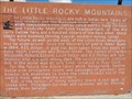 view gallery view gallerySE99.3 km | The Little Rocky Mountains II - Zortman, MT in Montana Historical Markers Along Highway 191 in north central Montana, at the junction with Highway 66 are a pair of Montana Historical Highway Markers, each describing a different aspect of the Little Rocky Mountains. posted by: T0SHEA location: Montana date approved: 08/06/2017 last visited: never |
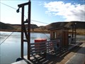 view gallery view gallerySW100.3 km |  Virgelle Ferry - Virgelle, MT Virgelle Ferry - Virgelle, MT
in Ferries and Ferry Landings The Virgelle Ferry crossing has been operating since 1918, and is one of two state owned ferries along the Missouri River found in Montana. posted by: CerealBoxMonsters location: Montana date approved: 10/26/2009 last visited: 07/29/2015 |
 view gallery view galleryN102.2 km | Crazy Horse Camp in Saskatchewan Historical Markers A few kilometers West of Eastend Saskatchewan. posted by: Altima Voyageur location: Saskatchewan, Canada date approved: 09/22/2013 last visited: never |
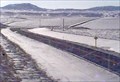
 view gallery view galleryW104.4 km | Inverness Web Camera - Inverness, MT in Web Cameras This is one of 73 (as of January 2017) Road Weather Information System camera sites operated by the Montana Department of Transportation to aid motorists as they make their way across BIG SKY Country. posted by: T0SHEA location: Montana date approved: 01/28/2017 last visited: never |
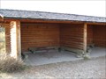 view gallery view gallerySW105.9 km |  Hole-in-the-Wall Shelters - Upper Missouri National Wild and Scenic River, MT Hole-in-the-Wall Shelters - Upper Missouri National Wild and Scenic River, MT
in Remote Backcountry Shelters These twin open-air shelters are located along the Upper Missouri Wild & Scenic River at River Mile 69.2R. They are only accessible by boat, and are available on a first-come basis. posted by: CerealBoxMonsters location: Montana date approved: 10/26/2009 last visited: never |
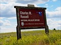 view gallery view galleryS106.1 km |  Charles M. Russell National Wildlife Refuge - Fergus County, MT Charles M. Russell National Wildlife Refuge - Fergus County, MT
in National Wildlife Refuges Established in 1936, the Charles M. Russell Wildlife Refuge has become a very popular hunting and recreational area in Montana. posted by: T0SHEA location: Montana date approved: 05/16/2019 last visited: never |
|