 view gallery view gallery NW0.2 km NW0.2 km
|   N48 31 00.6 W068 28 10.0 - Rimouski, QC N48 31 00.6 W068 28 10.0 - Rimouski, QC
in Permanent Geographic Coordinates These coordinates are written on a geodetic monument situated on the site historique maritime de Pointe-au-Père, Rimouski. posted by:  denben denben location: Québec, Canada date approved: 08/19/2012 last visited: 09/18/2019 |
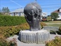
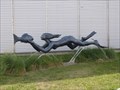 view gallery view galleryNW0.2 km |  La Grande Nageuse - Rimouski, Québec La Grande Nageuse - Rimouski, Québec
in Figurative Public Sculpture Cette sculpture, située a proximité du Pavillon de l'Empress of Ireland, a été réalisée par Roger Langevin en 2004. This sculpture, located in close proximity to the Empress of Ireland Pavilion, was created by Roger Langevin in 2004. posted by:  Weathervane Weathervane location: Québec, Canada date approved: 03/24/2019 last visited: 08/23/2021 |
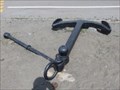 view gallery view galleryNW0.2 km |  Ancre à Jas - Pavillon Empress of Ireland - Stock Anchor - Empress of Ireland Pavilion - Rimouski, Québec Ancre à Jas - Pavillon Empress of Ireland - Stock Anchor - Empress of Ireland Pavilion - Rimouski, Québec
in Anchors Cette ancre de couleur noire est située entre le pavillon de l'Empress of Ireland et la rue de la Plage, à Rimouski. This black anchor is located between the Empress of Ireland's Pavilion and de la Plage Street, in Rimouski. posted by: Weathervane location: Québec, Canada date approved: 03/25/2019 last visited: 07/16/2016 |
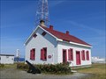
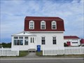
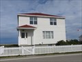 view gallery view galleryNW0.2 km | ") Maison du gardien - Rimouski (Pointe-au-Père) Québec Maison du gardien - Rimouski (Pointe-au-Père) Québec
in Histoire du Quebec (Quebec Historical Markers) La maison du gardien du phare a été construite en 1956; il s'agit de l'une des dernières constructions à être érigées sur le site. Le dernier gardien du phare y est demeuré de 1956 jusqu'en 1988. posted by: Weathervane location: Québec, Canada date approved: 05/11/2014 last visited: 08/23/2021 |
 view gallery view galleryNW0.3 km | Secteur du phare de Pointe-au-Père - Rimouski, Québec in Histoire du Quebec (Quebec Historical Markers) Établi en 1859, le secteur du phare de Pointe-au-Père se compose du phare historique en béton armé, d'une structure à claire-voie, de deux résidences, d'un abri pour le criard de brume, d'un garage, d'un réservoir, et de deux petits hangars. posted by: Weathervane location: Québec, Canada date approved: 05/11/2014 last visited: 08/23/2021 |
 view gallery view galleryNW0.3 km | Abri du criard de brume - Rimouski, (Pointe-au-Père) Québec in Histoire du Quebec (Quebec Historical Markers) L'Abri du criard de brume, aussi connu sous le nom de hangar de la corne de brume, date de 1903, et est le plus vieux bâtiment construit sur le site du Secteur du phare de Pointe-au-Père. posted by: Weathervane location: Québec, Canada date approved: 05/11/2014 last visited: 08/23/2021 |
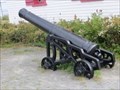 view gallery view galleryNW0.3 km |  Canon Blomefield, 18 livres - 18 pounder Blomefield Cannon - Rimouski, Québec Canon Blomefield, 18 livres - 18 pounder Blomefield Cannon - Rimouski, Québec
in Static Artillery Displays Ce canon est situé sur le terrain du Phare de Pointe-au-Père, à Rimouski, Québec. This cannon is located on the grounds of the Pointe-au-Père lighthouse, in Rimouski, Quebec. posted by: Weathervane location: Québec, Canada date approved: 04/06/2019 last visited: 08/23/2021 |
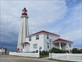
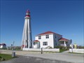
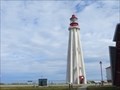
 view gallery view galleryNW0.3 km | Phare de Pointe-au-Père - Rimouski, Québec in Histoire du Quebec (Quebec Historical Markers) Le phare de Pointe-au-Père a été construit en 1909. Il est le troisième phare à être érigé sur ce site. D'une hauteur de 33 mètres et construit en béton armé, il est le deuxième phare le plus haut au Canada. posted by: Weathervane location: Québec, Canada date approved: 05/11/2014 last visited: 09/13/2018 |
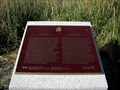
 view gallery view galleryNW0.3 km |  Establishment and Role of St Lawrence River Pilots National Historic Event of Canada, Pointe-au-Père, Quebec Establishment and Role of St Lawrence River Pilots National Historic Event of Canada, Pointe-au-Père, Quebec
in Canadian National Historic Sites Professional river pilots have played an important role in safe navigation of the treacherous St Lawrence River for over 350 years. Pointe-au-Père used to be the pilot station but that function is now carried out at Les Escoumins on the North Shore. posted by: colincan location: Québec, Canada date approved: 12/25/2016 last visited: 01/13/2019 |
 view gallery view galleryNW0.3 km | Pointe-au-Père Lighthouse National Historic Site of Canada, Quebec in Canadian National Historic Sites Pointe-au-Père Lighthouse is one of Canadas most impressive coastal navigational aids. Only Cap-des-Rosiers Lighthouse is taller. Technological advances to warn vessels i.e. acetylene lamps and the diaphone fog alarm, were implemented here. posted by: colincan location: Québec, Canada date approved: 12/21/2016 last visited: 08/23/2021 |
 view gallery view galleryNW0.3 km |  Phare de Pointe-au-Père - Pointe-au-Père Lighthouse - Rimouski, Québec Phare de Pointe-au-Père - Pointe-au-Père Lighthouse - Rimouski, Québec
in Coastal Lighthouses Le Phare de Pointe-au-Père, construit en 1909, est situé sur l'avenue du Père Nouvel Nord et la Route 132 à Rimouski. The Pointe-au-Père lighthouse, built in 1909, is located on Père Nouvel Avenue north and Highway 132 in Rimouski. posted by: Weathervane location: Québec, Canada date approved: 02/18/2019 last visited: 08/23/2021 |
 view gallery view gallery N0.3 km N0.3 km
| Ancienne maison du gardien - Rimouski (Pointe-au-Père), Québec in Histoire du Quebec (Quebec Historical Markers) Construite en 1909, la maison de l'assistant gardien, aussi connue sous le nom de maison de l'ingénieur des signaux de brume, a logé le gardien du phare de 1918 à 1956, puis l'assistant du gardien de 1956 à 1980. posted by: Weathervane location: Québec, Canada date approved: 05/11/2014 last visited: 08/23/2021 |
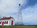 view gallery view galleryN0.3 km | Structure en claire-voie de Pointe-au-Père - Rimouski, Québec in Histoire du Quebec (Quebec Historical Markers) À l'est du phare historique de Pointe-au-Père construit en béton armé, se dresse aujourd'hui un quatrième phare, construit en 1975, sur le modèle alors typique d'une structure à claire-voie, et qui découle de l'automatisation de la station-phare. posted by: Weathervane location: Québec, Canada date approved: 05/11/2014 last visited: 08/23/2021 |
 view gallery view galleryNW0.3 km | The Wreck of RMS Empress of Ireland - Rimouski, QC in Canadian National Historic Sites The memorial is located on the shores of the St. Lawrence River, behind the keeper's house, at the Site Historique Maritime de la Pointe-au-Père in Rimouski, QC. posted by: denben location: Québec, Canada date approved: 08/18/2012 last visited: 08/22/2018 |
 view gallery view galleryNW0.3 km |  Wreck of RMS Empress of Ireland Memorial - Rimouski, QC Wreck of RMS Empress of Ireland Memorial - Rimouski, QC
in Maritime Monuments and Memorials The memorial is located on the shores of the St. Lawrence River, behind the keeper's house, at the Site Historique Maritime de la Pointe-au-Père in Rimouski, QC. posted by: denben location: Québec, Canada date approved: 08/18/2012 last visited: 08/22/2018 |
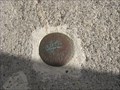 view gallery view galleryNW0.3 km |  LEVÉS GÉODÉSIQUE no. 83L136 LEVÉS GÉODÉSIQUE no. 83L136
in Canadian Benchmarks CANADIAN GEODESIC SURVEY
LEVÉS GÉODÉSIQUE CANADIENNE posted by: ve0mow location: Québec, Canada date approved: 05/29/2016 last visited: 08/22/2022 |
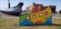 view gallery view galleryNW0.3 km |  Sous-marin photo cutout- Rimouski, Qc Sous-marin photo cutout- Rimouski, Qc
in Photo Cutouts Ce photo cutout est situé sur le site du sous-marin Onondaga à Rimouski. posted by: LadyKarine location: Québec, Canada date approved: 09/02/2019 last visited: 09/18/2019 |
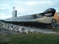 view gallery view galleryNW0.3 km | ") Le sous-marin NCSM ONONDAGA - Rimouski, QC, Canada Le sous-marin NCSM ONONDAGA - Rimouski, QC, Canada
in Military Ships and Submarines (Decommissioned) Le sous-marin Onondaga est le seul sous-marin accessible au public au Canada. posted by: Jean-Moo location: Québec, Canada date approved: 12/21/2011 last visited: 08/21/2022 |
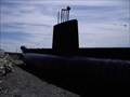 view gallery view galleryNW0.3 km |  NCSM Onondaga - Rimouski, Qc, Canada NCSM Onondaga - Rimouski, Qc, Canada
in Landlocked Boats NCSM Onondaga is located in Rimouski, Qc, Canada. posted by: tatie location: Québec, Canada date approved: 04/23/2012 last visited: 08/22/2018 |
 view gallery view gallery NE0.3 km NE0.3 km
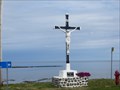
| Calvaire de la rue du Parc - Rimouski (Pointe-au-Père), Québec in Histoire du Quebec (Quebec Historical Markers) Le calvaire de la rue du Parc est un don de Madame Jean Heppell à la communauté de Pointe-au-Père. La croix fut erigée en 1934 au coin des rues du Parc et du Phare. posted by: Weathervane location: Québec, Canada date approved: 05/11/2014 last visited: 09/18/2019 |
 view gallery view gallery E0.5 km E0.5 km
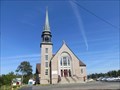
|  Église de Sainte-Anne - Sainte-Anne's Church - Rimouski, Québec Église de Sainte-Anne - Sainte-Anne's Church - Rimouski, Québec
in Bell Towers L'Église de Sainte-Anne, construite en 1959/1960, est située sur la rue du Parc, à Rimouski. The Church of St. Anne, built in 1959/1960, is located on Parc Street in Rimouski. posted by: Weathervane location: Québec, Canada date approved: 04/06/2019 last visited: 07/29/2015 |
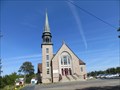 view gallery view galleryE0.5 km | Église de Sainte-Anne - Rimouski, Québec in Histoire du Quebec (Quebec Historical Markers) L'Église de Sainte-Anne, construite en 1959/1960, est située sur la rue du Parc, à Rimouski (Pointe-au-Père). posted by: Weathervane location: Québec, Canada date approved: 09/06/2013 last visited: 07/29/2015 |
 view gallery view gallery SE0.6 km SE0.6 km
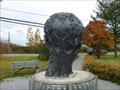
|  Arbre du millénaire-Pointe-au-Père, Qc, Canada Arbre du millénaire-Pointe-au-Père, Qc, Canada
in Millennium Trees L’arbre du millénaire. Vision du passé, du présent et du futur posted by: gemeloj location: Québec, Canada date approved: 04/17/2017 last visited: 09/18/2019 |
 view gallery view gallerySE0.6 km | L'arbre du Millénaire - (Millennium Tree) - Rimouski, Québec in Figurative Public Sculpture Cette sculpture, réalisée par André Gamache en 2000, est située au coin de la rue du Parc et de l'avenue du Père Nouvel Nord. This sculpture, created by Andre Gamache in 2000, is located at the corner of du Parc Street and Père Nouvel Nord Avenue. posted by: Weathervane location: Québec, Canada date approved: 03/28/2019 last visited: 01/13/2019 |
 view gallery view gallery SW2.9 km SW2.9 km
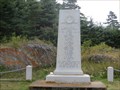
| Monument commémoratif du naufrage de l'Empress of Ireland - Rimouski, Québec in Histoire du Quebec (Quebec Historical Markers) Le monument commémoratif du naufrage de l'Empress of Ireland, érigé par la compagnie Canadian Pacific Railway, est situé sur la route du fleuve, à Rimouski. posted by: Weathervane location: Québec, Canada date approved: 05/04/2014 last visited: 02/11/2017 |
|