 view gallery view gallery NE16.4 km NE16.4 km
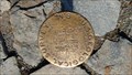
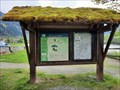
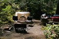
|   Cascade Pass Geological Survey BM 5392 Cascade Pass Geological Survey BM 5392
in U.S. Benchmarks At Cascade Pass in the North Cascades National Park is a metal post with a round brass cap, a US Geological Survey bench mark. The elevation 5392 feet above sea level is embossed on the 4' diameter cap. posted by:  arby101ca arby101ca location: Washington date approved: 09/27/2016 last visited: 09/05/2017 |
 view gallery view gallery NW20.4 km NW20.4 km
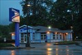
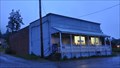
|  Marblemount, Washington 98267 Marblemount, Washington 98267
in U.S. Post Offices This Post Office is located at 60096 State Route 20 in Marblemount, Washington. posted by:  brwhiz brwhiz location: Washington date approved: 01/28/2013 last visited: never |
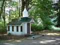 view gallery view galleryNW21.2 km |  Wildwood Chapel - Marblemount, WA Wildwood Chapel - Marblemount, WA
in Waychapels The Wildwood Chapel lies alongside the scenic North Cascades Highway. It was built in 1977 and is used as a roadside chapel and is also rented for weddings. The chapel has an alter and seats 6-9 people. posted by: Hikenutty location: Washington date approved: 07/28/2008 last visited: 11/21/2013 |
 view gallery view gallery N24.5 km N24.5 km
| ") North Cascades National Park - Sedro-Woolley, WA North Cascades National Park - Sedro-Woolley, WA
in National Parks (U.S.) North Cascades National Park features the rugged mountain peaks of the North Cascades Range, the most expansive glacial system in the contiguous United States, and the headwaters of numerous waterways. posted by: RakeInTheCache location: Washington date approved: 05/23/2023 last visited: 08/15/2022 |
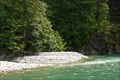
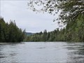
 view gallery view galleryNW24.6 km |  Skagit River - Rest Area - Rockport, WA Skagit River - Rest Area - Rockport, WA
in National Wild and Scenic Rivers The Skagit River is approximately 150 mi (240 km) long which originates at Allison Pass in the Canadian Cascades of British Columbia. posted by: RakeInTheCache location: Washington date approved: 05/29/2023 last visited: 08/15/2022 |
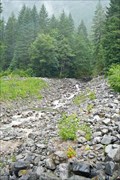 view gallery view galleryN27 km |  Damnation Creek - North Cascades Hwy, WA Damnation Creek - North Cascades Hwy, WA
in Geological Devilish Locations Damnation Creek crosses the North Cascades Highway here as a tiny stream. Sure doesn't look like something that would be named after the state of being damned to hell. posted by: Hikenutty location: Washington date approved: 08/17/2008 last visited: never |
 view gallery view gallery W27.4 km W27.4 km
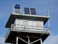
|  Solar Panels for North Mountain Lookout Solar Panels for North Mountain Lookout
in Solar Power Solar Panels provide energy for the North Mountain Lookout posted by: Harriet the Spy location: Washington date approved: 11/02/2007 last visited: never |
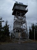 view gallery view galleryW27.4 km |  North Mountain Lookout North Mountain Lookout
in Look-Out Towers Lookout on North Mountain posted by: Harriet the Spy location: Washington date approved: 11/04/2007 last visited: never |
 view gallery view galleryNW28 km | Rockport, Washington 98283 in U.S. Post Offices This Post Office is located at 52779 Railroad Avenue in Rockport, Washington. posted by: brwhiz location: Washington date approved: 01/28/2013 last visited: never |
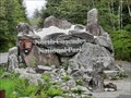
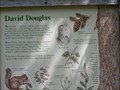 view gallery view galleryW29.1 km |  David Douglas David Douglas
in Washington Historical Markers David Douglas
The Douglas Fir owes its name to David Douglas
The marker is located in the Rockport State Park posted by: talks2animals location: Washington date approved: 05/08/2006 last visited: 07/05/2013 |
 view gallery view gallery SW29.8 km SW29.8 km
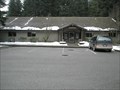
|  Darrington Ranger Station, Mt. Baker Snoqualmie National Forest Darrington Ranger Station, Mt. Baker Snoqualmie National Forest
in Ranger Stations Darrington Ranger Station Manages the Mt. Baker Snoqualmie National Forest. posted by: Harriet the Spy location: Washington date approved: 02/15/2008 last visited: 11/20/2013 |
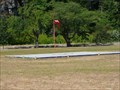
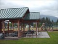 view gallery view gallerySW30.3 km |  Old School Park, Darrington WA Old School Park, Darrington WA
in Public Playgrounds A great place to play in the shadow of Whitehorse Mt. posted by: Harriet the Spy location: Washington date approved: 06/06/2006 last visited: 02/02/2013 |
 view gallery view galleryN30.9 km |  North Cascades National Park North Cascades National Park
in NPS Passport Cancellation Stations Primarily a back country national park, the North Cascades National Park provides visitors with a large assortment of hiking areas and places to explore without the big crowds that you might experience at some of the other parks. posted by: pdxmickey location: Washington date approved: 07/16/2006 last visited: 07/02/2005 |
 view gallery view galleryN31.1 km |  Newhalem Campground, North Cascades National Park - Newhalem, WA Newhalem Campground, North Cascades National Park - Newhalem, WA
in Campgrounds Newhalem Campground is located adjacent to the North Cascades National Park Newhalem Visitor Center. It is close to numerous trailheads, lakes, and the Skagit River. posted by: Hikenutty location: Washington date approved: 08/05/2008 last visited: never |
 view gallery view galleryN31.5 km |  Newhalem Helicopter Landing Pad - Newhalem, WA Newhalem Helicopter Landing Pad - Newhalem, WA
in Helicopter Landing Pads Newhalem is a tiny town in the North Cascades that is owned by Seattle City Light. This pad, located in the center of town is used by the power company and also by the National Park Service to access remote parts of North Cascades NP. posted by: Hikenutty location: Washington date approved: 07/28/2008 last visited: never |
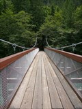 view gallery view galleryN31.5 km |  Trail of the Cedars Bridge - Newhalem, WA Trail of the Cedars Bridge - Newhalem, WA
in Pedestrian Suspension Bridges The Trail of the Cedars starts from this suspension bridge in the town of Newhalem. The bridge crosses the Skagit River, just down from the Gorge Powerhouse. posted by: Hikenutty location: Washington date approved: 08/07/2008 last visited: 10/12/2009 |
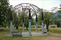 view gallery view galleryN31.5 km |  Temple of Power - Seattle City Light, Newhalem, WA Temple of Power - Seattle City Light, Newhalem, WA
in Seattle Art and Seek This interesting sculpture was created using recycled bushings from the nearby Diablo switchyard. Newhalem is a town owned by Seattle City Light and this domed gazebo ties into its long history as a provider of Seattle's electricity. posted by: Hikenutty location: Washington date approved: 08/04/2008 last visited: 10/12/2009 |
 view gallery view galleryN31.5 km |  Temple of Power - Seattle City Light, Newhalem, WA Temple of Power - Seattle City Light, Newhalem, WA
in Abstract Public Sculptures This interesting sculpture was created using recycled bushings from the nearby Diablo switchyard. Newhalem is a town owned by Seattle City Light and this domed gazebo ties into its long history as a provider of Seattle's electricity. posted by: Hikenutty location: Washington date approved: 08/04/2008 last visited: 10/12/2009 |
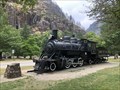 view gallery view galleryN31.7 km |  Old Number 6 - Newhalem, Washington Old Number 6 - Newhalem, Washington
in Locomotives Located on the westbound side of Newhalem Street posted by: flyingmoose location: Washington date approved: 01/16/2023 last visited: never |
 view gallery view galleryN31.7 km |  CONFLUENCE - Ladder Creek/Skagit River - Newhalem, WA CONFLUENCE - Ladder Creek/Skagit River - Newhalem, WA
in River Origins, Destinations and Confluences Ladder Creek ends in a jumble of stepped falls and then flows into the Skagit River, just downriver from the Gorge Dam Powerhouse in the town of Newhalem. posted by: Hikenutty location: Washington date approved: 08/04/2008 last visited: never |
 view gallery view galleryN31.7 km | Gorge Powerhouse Suspension Bridge - Newhalem, WA in Pedestrian Suspension Bridges This suspension bridge was originally built in the 1920's to give workers access to the Gorge Powerhouse on the Skagit River. It has been rebuilt several times and now provides access to the Ladder Creek Falls trail. posted by: Hikenutty location: Washington date approved: 08/07/2008 last visited: 10/12/2009 |
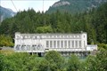 view gallery view galleryN31.7 km |  Gorge Power Plant - Newhalem, WA Gorge Power Plant - Newhalem, WA
in American Guide Series The Gorge Powerhouse was constructed in 1924 in the Seattle City Light owned town of Newhalem. Its turbines are spun from water diverted from the Gorge Dam, three miles upstream, into a tunnel that leads to the powerhouse. posted by: Hikenutty location: Washington date approved: 08/07/2008 last visited: 10/12/2009 |
 view gallery view galleryN32 km | Ladder Creek Falls and Garden - Newhalem, WA in American Guide Series Ladder Creek Falls is located near the Gorge Powerhouse in Newhalem. A short, 1/4 mile trail leads up to the falls and around a historic garden adjacent to the Gorge Powerhouse.
posted by: Hikenutty location: Washington date approved: 08/07/2008 last visited: never |
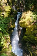 view gallery view galleryN32 km |  Ladder Creek Falls - Newhalem, WA Ladder Creek Falls - Newhalem, WA
in Waterfalls Ladder Creek Falls is located near the Gorge Powerhouse in Newhalem. A short, 1/4 mile trail leads up to the falls and around a historic garden adjacent to the Gorge Powerhouse. posted by: Hikenutty location: Washington date approved: 08/04/2008 last visited: never |
 view gallery view galleryNW34.1 km | Skagit River - Faber Ferry North Boat Launch - Concrete, WA in National Wild and Scenic Rivers The Skagit River is approximately 150 mi (240 km) long which originates at Allison Pass in the Canadian Cascades of British Columbia. posted by: RakeInTheCache location: Washington date approved: 05/21/2023 last visited: never |
|