 view gallery view gallery SW4.8 km SW4.8 km
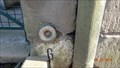
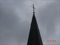
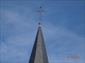
|   Eglise de Chatel sur Moselle Eglise de Chatel sur Moselle
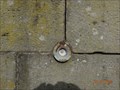
in French Benchmarks sur la façade de l'église a gauche du porche d'entrée a 0,51 m do sol posted by:  geotrou geotrou location: Grand-Est, France date approved: 03/07/2015 last visited: never |
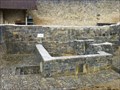 view gallery view gallerySW5 km |  La Forge du Fort -Chatel-sur-Moselle-Lorraine, France La Forge du Fort -Chatel-sur-Moselle-Lorraine, France
in Iron Furnace Ruins Un très vieux fort! A very old Fort ! posted by: gemeloj location: Grand-Est, France date approved: 11/22/2014 last visited: 03/07/2015 |
 view gallery view gallerySW5 km |  Fort de Chatel-sur-Moselle-Lorraine,France Fort de Chatel-sur-Moselle-Lorraine,France
in Historic Forts L’un des plus impressionnantes forteresses de France. One of the most impressive fortresses in France. posted by: gemeloj location: Grand-Est, France date approved: 11/17/2014 last visited: 03/07/2015 |
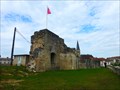 view gallery view gallerySW5 km |  La forteresse de Chatel-sur-Moselle-Lorraine,France La forteresse de Chatel-sur-Moselle-Lorraine,France
in Monuments Historiques Français L’un des plus impressionnantes forteresses de France. posted by: gemeloj location: Grand-Est, France date approved: 11/16/2014 last visited: 03/07/2015 |
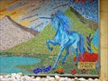 view gallery view gallerySW5 km |  La licorne bleue-Chatel-sur-Moselle-Lorraine,France La licorne bleue-Chatel-sur-Moselle-Lorraine,France
in Mosaics A beautiful mosaic! Une superbe mosaique! posted by: gemeloj location: Grand-Est, France date approved: 11/16/2014 last visited: 03/07/2015 |
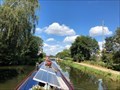
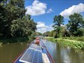
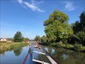
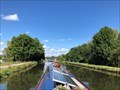
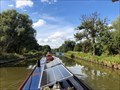 view gallery view gallerySW5.3 km |  Écluse 26 (nord) - l'Avière - Canal des Vosges - Nomexy - France Écluse 26 (nord) - l'Avière - Canal des Vosges - Nomexy - France
in Waterway Locks, Planes and Lifts This is lock number 26 on the northern slope of the Canal des Vosges and is known as l'Avière. posted by: ntpayne location: Grand-Est, France date approved: 11/09/2021 last visited: never |
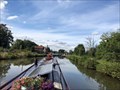
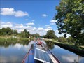
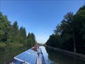
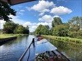 view gallery view gallerySW5.5 km | Écluse 25 (nord) - Nomexy - Canal des Vosges - Nomexy - France in Waterway Locks, Planes and Lifts This is lock number 25 on the northern slope of the Canal des Vosges and is known as Nomexy. posted by: ntpayne location: Grand-Est, France date approved: 11/09/2021 last visited: never |
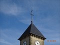
 view gallery view gallery NE5.6 km NE5.6 km
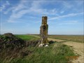
| cheminée Géodésique de Rehaincourt in French Benchmarks repére bronze au centre surmonté d'une cheminée
borne SGA 1899 posted by: geotrou location: Grand-Est, France date approved: 10/20/2014 last visited: never |
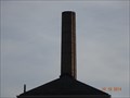 view gallery view gallerySW5.8 km | Benchmarck Géodésique Nomexy cheminée in French Benchmarks Cheminée:axe et sommet posted by: geotrou location: Grand-Est, France date approved: 10/20/2014 last visited: never |
 view gallery view gallerySW6 km | l'eglise de Nomexy in French Benchmarks a droite de l'entée de l'église a 40 cm du sol posted by: geotrou location: Grand-Est, France date approved: 09/30/2014 last visited: never |
 view gallery view gallery W6.1 km W6.1 km
| Écluse 27 (nord) - Fouys - Canal des Vosges - Portieux - France in Waterway Locks, Planes and Lifts This is lock number 27 on the northern slope of the Canal des Vosges and is known as Fouys. posted by: ntpayne location: Grand-Est, France date approved: 11/09/2021 last visited: never |
 view gallery view gallerySW6.1 km | Écluse 24 (nord) - la Héronnière - Canal des Vosges - Nomexy - France in Waterway Locks, Planes and Lifts This is lock number 24 on the northern slope of the Canal des Vosges and is known as la Héronnière. posted by: ntpayne location: Grand-Est, France date approved: 11/09/2021 last visited: never |
 view gallery view gallery E6.9 km E6.9 km
| Benchmarck Géodésique église de St Genest in French Benchmarks clocher centre boule posted by: geotrou location: Grand-Est, France date approved: 10/19/2014 last visited: never |
 view gallery view galleryW6.9 km | Écluse 28 (nord) - Portieux - Canal des Vosges - Portieux - France in Waterway Locks, Planes and Lifts This is lock number 28 on the northern slope of the Canal des Vosges and is known as Portiuex. It can be found in the village of Portiuex. posted by: ntpayne location: Grand-Est, France date approved: 11/11/2021 last visited: never |
 view gallery view galleryW7.7 km | Benchmarck Géodésique église de Vincey in French Benchmarks Point A:clocher centre boule posted by: geotrou location: Grand-Est, France date approved: 10/22/2014 last visited: never |
 view gallery view galleryW7.7 km | Eglise de Vincey in French Benchmarks au début du mur latéral droit de l'eglise a 30 cm de hauteur posted by: geotrou location: Grand-Est, France date approved: 10/04/2014 last visited: never |
 view gallery view gallery S7.7 km S7.7 km
| Écluse 23 (nord) - Vaxoncourt - Canal des Vosges - Vaxoncourt - France in Waterway Locks, Planes and Lifts This is lock number 23 on the northern slope of the Canal des Vosges and is known as Vaxoncourt. posted by: ntpayne location: Grand-Est, France date approved: 11/09/2021 last visited: never |
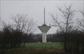
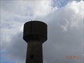 view gallery view galleryW7.9 km | Benchmarck Géodésique chateau d'eau Vincey in French Benchmarks Point A trou d'homme axe et sommet posted by: geotrou location: Grand-Est, France date approved: 10/22/2014 last visited: never |
 view gallery view galleryE7.9 km | Benchmarck Géodésique église de Moyemont in French Benchmarks Clocher point A centre croix
Clocher point B centre boule posted by: geotrou location: Grand-Est, France date approved: 10/19/2014 last visited: never |
 view gallery view galleryW8 km | Écluse 29 (nord) - Vincey - Canal des Vosges - Portieux - France in Waterway Locks, Planes and Lifts This is lock number 29 on the northern slope of the Canal des Vosges and is known as Vincey. posted by: ntpayne location: Grand-Est, France date approved: 11/11/2021 last visited: never |
 view gallery view galleryE8.2 km | Benchmarck Géodésique Ch d'eau Darnieulles in French Benchmarks point a borne granit gravée IGN
point B Ch d'eau plate forme surerieure plaque collée
point C axe sommet posted by: geotrou location: Grand-Est, France date approved: 12/14/2014 last visited: never |
 view gallery view galleryS8.5 km | Écluse 22 (nord) - Igney - Canal des Vosges - Igney - France in Waterway Locks, Planes and Lifts This is lock number 22 on the northern slope of the Canal des Vosges and is known as Igney. posted by: ntpayne location: Grand-Est, France date approved: 11/09/2021 last visited: never |
 view gallery view galleryS9 km | Igney in French Benchmarks dans le collecteur d'eau des fossés au croisement de deux rues a 60 cm de hauteur posted by: geotrou location: Grand-Est, France date approved: 10/04/2014 last visited: never |
 view gallery view galleryS9.5 km | Écluse 21 (nord) - Plaine de Thaon - Canal des Vosges - Thaon-les-Vosges - France in Waterway Locks, Planes and Lifts This is lock number 21 on the northern slope of the Canal des Vosges and is known as Plaine de Thaon. posted by: ntpayne location: Grand-Est, France date approved: 11/09/2021 last visited: never |
 view gallery view galleryW10 km | Écluse 30 (nord) - Moulin de Charmes - Canal des Vosges - Charmes - France in Waterway Locks, Planes and Lifts This is lock number 30 on the northern slope of the Canal des Vosges and is known as Moulin de Charmes. posted by: ntpayne location: Grand-Est, France date approved: 11/11/2021 last visited: never |
|